Update: The forecast remains on track as the Hampton Roads region is expected to get blasted with wind and rain tonight.
The stormiest of the weather will crash into the region between 8 pm and 11 pm. At this point, expect winds for everyone to be gusting 50-60+mph. Power outages and tree damage is likely in sporadic locations. Rain will be heavy, causing isolated flooding, with strong to severe thunderstorms likely. An isolated tornado or two could develop as well, so be sure to stay weather aware this evening.
The threat of tidal flooding will peak this evening for those along the northern shore of the Albemarle and southern Back Bay region due to the strong southerly winds.
The storms blow offshore after midnight and skies gradually clear out overnight, but it will remain windy with west winds gusting to 40mph. While we anticipate the return of some sunshine tomorrow, it’ll remain cool and blustery, with winds gusting to 30-35mph for most of the day. This could cause some sound side flooding for the Outer Banks and part of the Eastern Shore.
Things calm down Thursday with cool and sunny conditions.
Stay weather aware tonight and stay safe!
-Steve
______________________________________________________________________________________________________
Today is the day! We haven’t had a storm like this in a while. Heavy rain and strong winds will be the main problems. However, isolated tornadoes and some flooding could also be an issue.
A large/strong area of low pressure has formed over the Tennessee River Valley. High pressure has moved offshore.
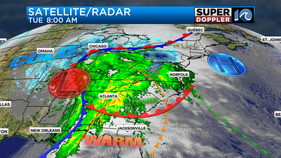
The storm system has already created a lot of problems with snow in the north central U.S. and severe storms in the deep south. It’s possible that some areas between the Midwest and Great Lakes could get about a foot of snow before the storm ends.
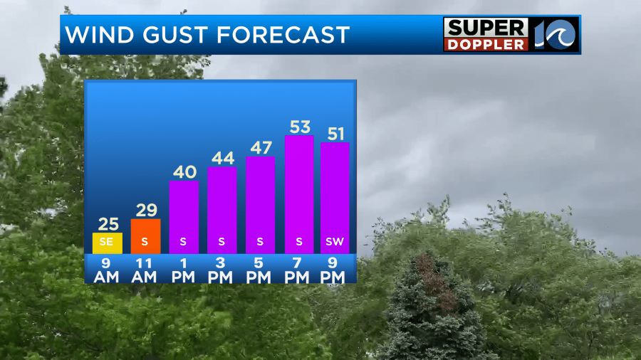
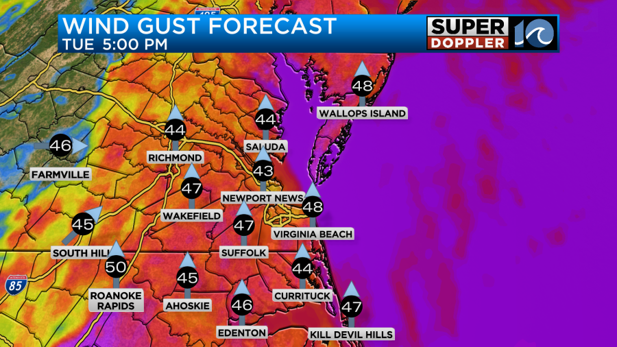
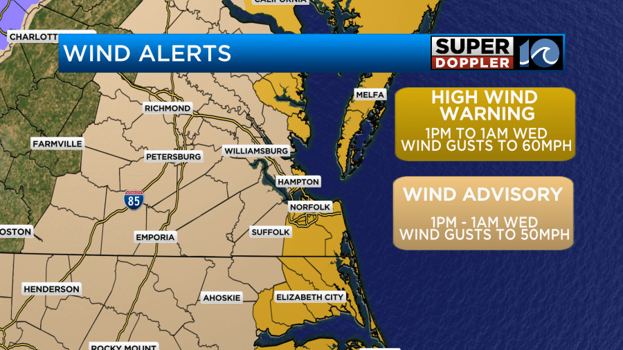
Locally, we’ll have a warm front push north of Hampton Roads as we go into the afternoon. Also, the pressure difference between the low to the west and the offshore high will create some very strong southerly/southeasterly winds. Winds will gust up to 40-45mph early this afternoon with winds gusting up to 45-55mph in the evening.
This will push our high temperatures up into the mid 60s this afternoon.
Winds may gust up to 60mph near the shore for a time. Especially towards the later evening.
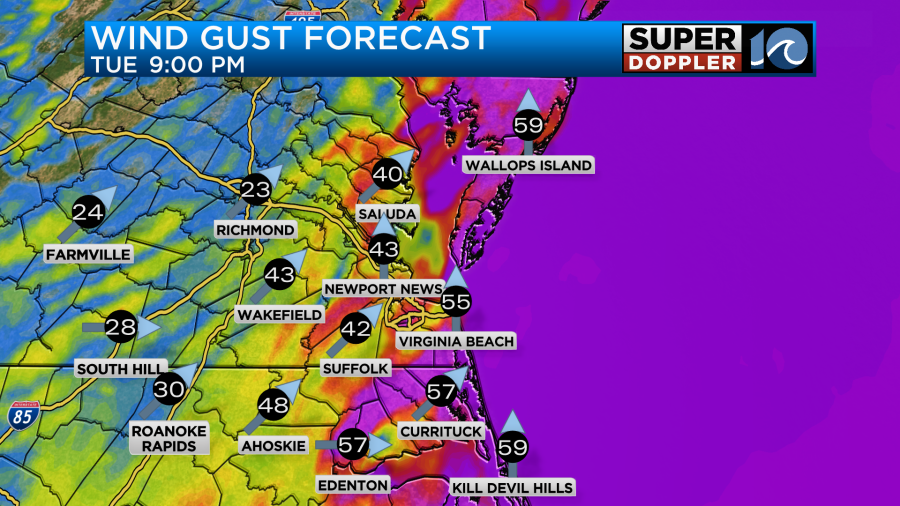
Therefore, there are High Wind Warnings up for areas near the shore and oceanfront. There are Wind Advisories for inland areas.
There may be some scattered power outages during the evening.
As for the rain….There was already a round of showers moving through the area this morning.
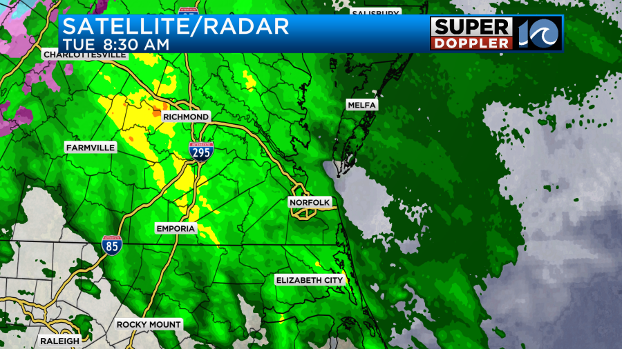
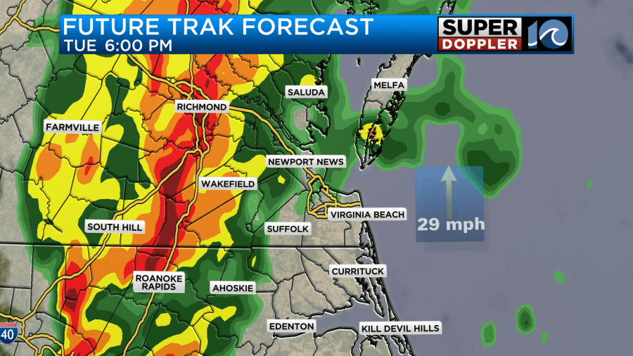
Our Future Trak model did s good job at picking up on this feature. This first round of showers will move through. Then we’ll have a bit of a lull around midday. There will still be some showers, but the coverage should drop. Rain will increase again in the afternoon. If you blend the HRRR model and the Graf model, then there is a pretty good shot at some rain during that time.
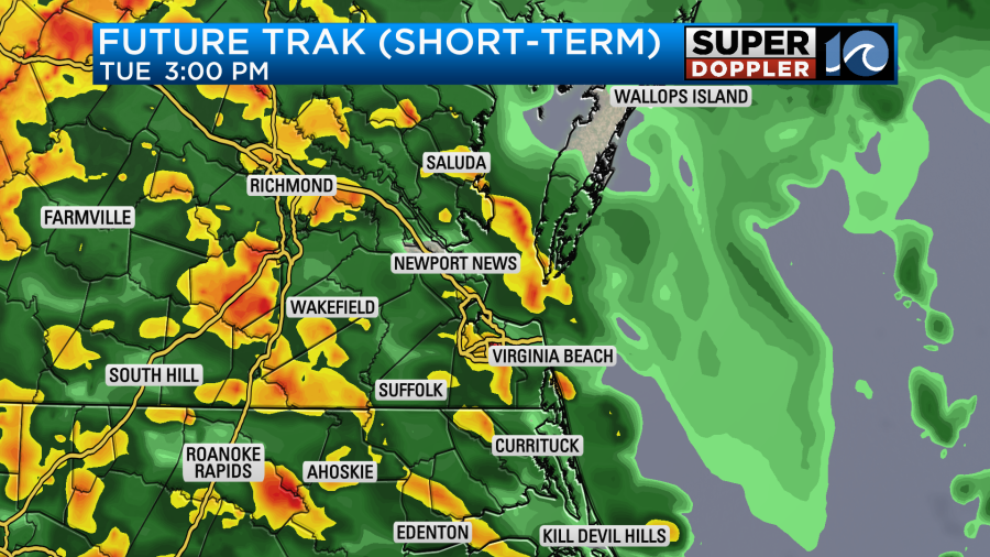
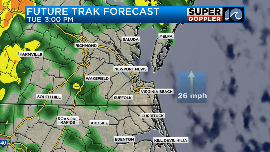
There will at least be a few heavy downpours rolling through the region. There may already be some isolated thunderstorms by that time. Remember, the general wind outside of any thunderstorms will be gusting to about 45mph. During the evening a cold front will be approaching from the west. Rain and wind will focus ahead of it. There may be some heavy downpours during the evening commute. Especially later in the commute.
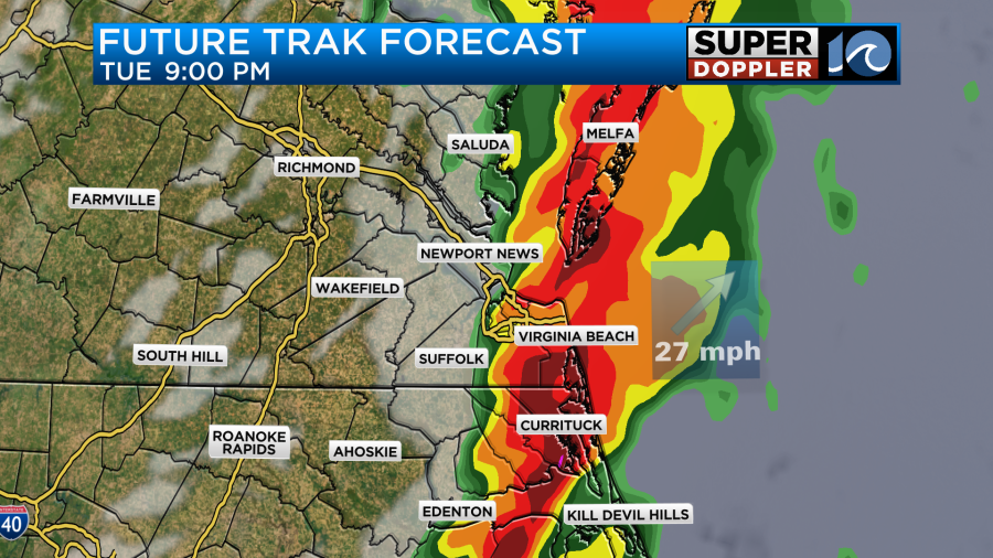
It’s during this time that I think the highest chance for any severe storms will be.
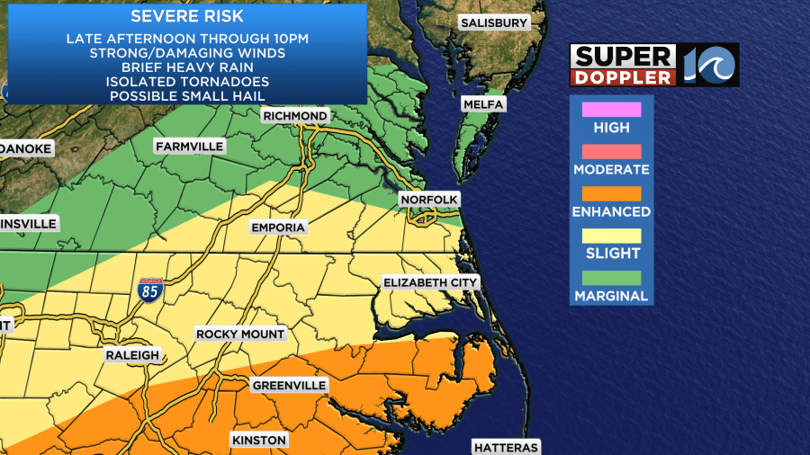
Strong damaging winds will definitely be the main threat, but isolated tornadoes cannot be ruled out. The higher threat for that will be to the south. After about 10pm the line of storms looks to roll offshore. Then we’ll dry out overnight. Winds will turn out of the west. Other than an isolated shower before 8am tomorrow Wednesday should be dry and windy.
The bulk of the heavy rain will likely fall between 6 and 10pm. It may be heavy enough to create some isolated areas of flooding. There is a flood watch for most of southeast Virginia.
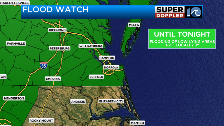
We could pick up 1-2″ of rainfall with some spots reaching 2-3″.
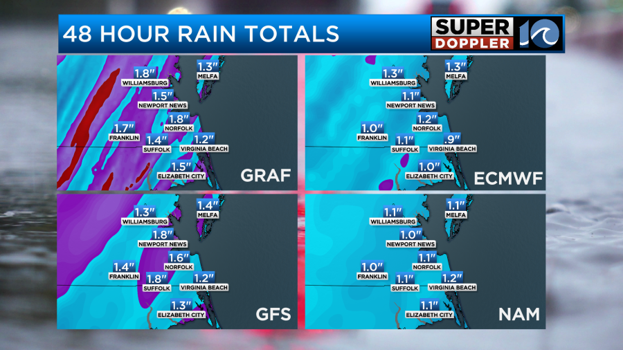
If most of that falls within a 2-3 hour window, then the flooding may become more common. This does not include tidal flooding.
The worst tidal flooding that we are expecting is on the north end of the Albemarle Sound. With the prolonged south/southeast winds today there will likely be moderate tidal flooding in that area.

There may even be some major tidal flooding in a few locations. This is expected from the late afternoon into the evening. Water levels of 2-3 ft above ground are possible in some of these areas. This will also affect Knotts Island and far southern Virginia Beach. We are not expecting tidal flooding over the lower Chesapeake Bay. The southerly then westerly winds are not conducive to tidal flooding.
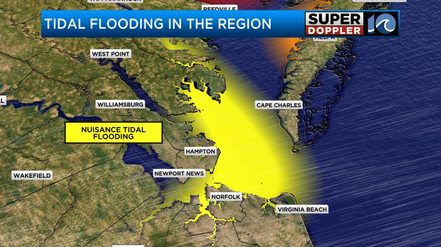
However, tomorrow there may be some moderate tidal flooding along the sound-side of the Outer Banks and up around the north end of Accomack county on the Bay side. There is a little more confidence that it will happen. However, we’ll see how high the water gets. The water could rise at least a couple feet above ground.
Tomorrow we’ll dry out with high temps in the 50s. We’ll have quiet/cool weather on Thursday with highs in the 50s. Then we’ll be dry for most of Friday, but some scattered showers may move in late in the day. There will be some more rain Friday night into Saturday morning. It could also be breezy. However, neither looks as bad as today’s rain & wind.
Stay tuned for updates throughout the day.
Meteorologist: Jeremy Wheeler