Yesterday was hot, but today is going to be hotter and a bit more humid. Yesterday I did some brief yard work. It wasn’t too bad at first, but it hot really hot by the end. I even got a bit light headed at one point. So I headed inside to hydrate up and cool down. There was a light breeze, and that helped at times. High temps made it into the low-mid 90s, but the heat indices were up around 105 and even higher in some locations.

Yesterday we had Heat Advisories for the area. Today we have an Excessive Heat Warning in effect.

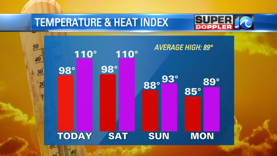
This means that the heat index could reach about 110 degrees or higher. In fact some locations could have a heat index up to 112 degrees.
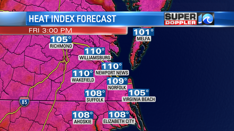
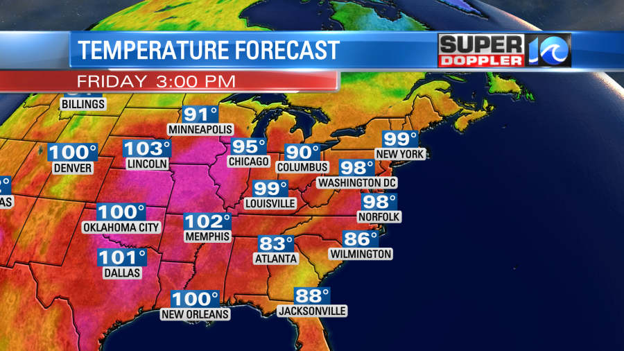
Those will likely be in the inland locations where our high temps could hit 100. Most temps today will be in the upper 90s.
Here are several reminders to beat the heat.

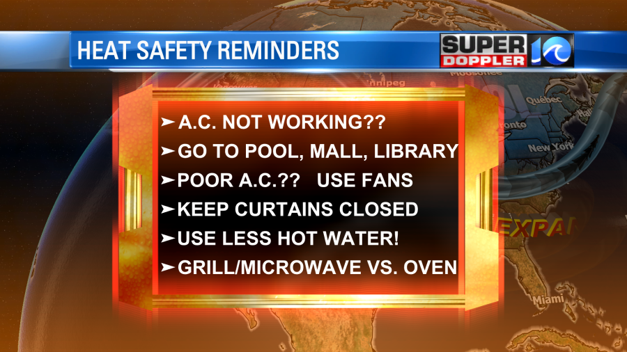
Staying hydrated and taking breaks in the shade or A.C. are the most important reminders along with not leaving kids nor pets in vehicles. When you have this type of heat, then heat illnesses are more likely to occur. These include heat cramps, heat exhaustion, and heat stroke. Here are some of the symptoms:

High pressure is offshore today. We’ll have a southwest wind at 8-12mph on the back side of it.
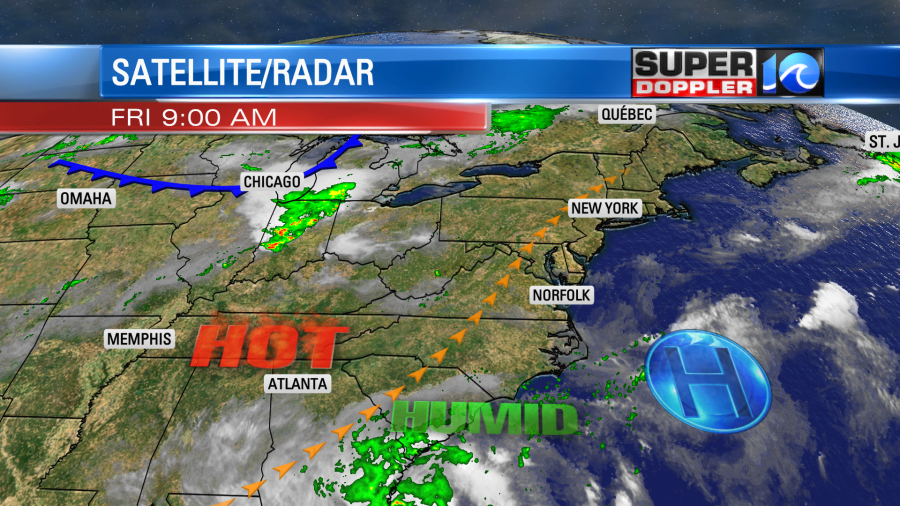
There is a cold front near Chicago, and that front will work down here by Sunday. More on that in a moment.
We’ll be mostly to partly sunny today. There will only be a stray shower or storm in the region. An isolated shower or storm may drift in from the west this evening. Tomorrow we’ll be partly cloudy for a while, but there will be a few showers and storms in the afternoon and evening. We will be partly cloudy most of the day. There will be a stronger breeze out of the southwest. It could even gust up to 25mph for a time.

While this will push more heat and humidity into our region, it will also help with the feels like temperature a bit. Overall, though it will be a hot breeze. High temps will run up into the upper 90s again tomorrow.

The heat index will again rise to the 100s. It will be between 106 and 112 degrees.
By Sunday a cool front will enter the region. High temps will be knocked down to the 80s.
There will be some scattered showers and storms, but it won’t be a washout. We’ll cool down some more and dry out into early next week.
Meanwhile we are keeping a close eye on that tropical disturbance in the middle of the Atlantic. It is moving west for now.

It has a medium chance of formation within the next 3-5 days. It is forecast to move west and then northwest. It would probably stay out to sea in a few days. It will (probably) head closer to Bermuda in that time. However, we’ll watch it over the weekend to be sure. There are 2 other small features that have a near-zero chance for development.
Stay cool and stay hydrated today! Hang in there until the cool down on Sunday.
Meteorologist: Jeremy Wheeler