Track the latest updates in our live blog for Thursday here.
Stay with 10 On Your Side and your Super Doppler 10 weather team on air and online at WAVY.com for the latest updates on Idalia, and be sure to download the WAVY Weather App for the latest weather alerts. WAVY News 10 will be on-air beginning at 4 a.m.
HAMPTON ROADS, Va. (WAVY) — Here are the latest updates on Idalia from across Hampton Roads, the Outer Banks and northeastern North Carolina.
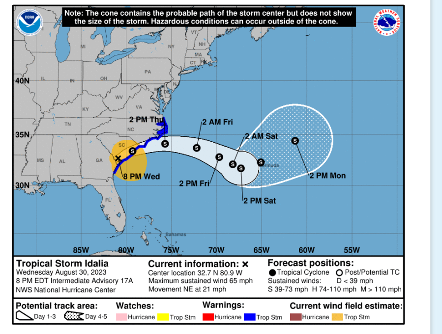
2:30 a.m. Thursday, Aug. 31: Idalia update from National Hurricane Center
Here’s the 2 a.m. public advisory on Idalia from the National Hurricane Center. The storm is about 20 miles southwest of Myrtle Beach, South Carolina and moving northeast at 21 mph. There is a tropical storm warning in effect from the South Santee River north to the North Carolina/Virginia border, as well as the Pamlico and Albemarle sounds.
There is a storm surge watch for Beaufort Inlet to Ocracoke Inlet, North Carolina, and the Neuse and Pamlico rivers. Storm surge from Ocracoke Inlet to Duck could reach one-to-three feet if the peak surge comes at high tide. Rain totals are forecast from four to eight inches with isolated areas up to 10 inches from eastern South Carolina through eastern North Carolina through Thursday.
A storm surge watch is defined as possible “life-threatening inundation from rising water moving inland from the shoreline somewhere within the specified area, generally within 48 hours, in association with a tropical, subtropical or post-tropical cyclone.” Here’s an overview of storm surge from the National Weather Service.
Maximum sustained winds are near 60 mph and tropical storm-force winds extend outward up to 205 miles from Idalia’s center. Little change in storm strength is forecast over the next two days, and it will remain a tropical storm even when it moves off the coast.
2 a.m. Thursday, Aug. 31: Updated N.C. school closures, weather update
A number of school divisions in northeastern North Carolina will either be closed or operating remotely Thursday, and many will wait on Idalia’s impacts to determine operations Friday. Added to the list of school closures: Camden County, College of the Albemarle and Currituck County.
In Virginia Beach, the Virginia Beach Friends School said it would close promptly at 3:15 p.m. Thursday due to forecasted weather and would not be holding afterschool activities, including after care.
1:45 a.m. Thursday, Aug. 31: Cluster of storms
Super Doppler 10 Chief Meteorologist Jeff Edmondson is keeping a close eye on a cluster of storms south of Ocracoke Island early this morning.
Midnight Thursday, Aug. 31: Active alerts
Check out the list of active watches, warnings and advisories for the Hampton Roads and northeastern North Carolina regions as it relates to Idalia.
11 p.m. Wednesday, Aug. 30: Warnings and watches in effect
OUTER BANKS, N.C. — The National Weather Service has issued a tornado watch in effect until 4 a.m. Thursday for Dare County. Currituck County, as well as Hatteras Island, mainland Dare County and northern Outer Banks locations inclusive of Kitty Hawk, Nags Head and Manteo, are under tropical storm and coastal flood warnings.
A flood watch is in effect for much of northeastern North Carolina, including Bertie, Camden, Chowan, Currituck, Gates, Hertford, Northampton (N.C.), Pasquotank and Perquimans counties. It took effect Wednesday afternoon and remains in effect through Thursday evening.
A wind advisory is also in effect for Virginia Beach, Norfolk, Portsmouth, Hampton, Poquoson and Northampton County on Virginia’s Eastern Shore from 7 a.m. to 7 p.m. Thursday. The National Weather Service says to expect northeast winds of 20 to 30 mph, with gusts of 40 to 45 mph.
VIRGINIA BEACH, Va. — Virginia Beach is under a coastal flood warning, effective at 6 a.m. Thursday through 2 p.m. Friday, and a high surf advisory is in effect from 10 a.m. Thursday through noon Friday.
A high surf advisory is also in effect in Accomack County from 7 a.m. Thursday through noon Friday. They are issued when breaking wave action poses a threat to life and property within the surf zone, according to the National Weather Service.
A coastal flood advisory is in effect from 8 a.m. Thursday until 8 p.m. for Surry and Isle of Wight counties, as well as Norfolk, Portsmouth, Suffolk and Chesapeake.
10 p.m. Wednesday, Aug. 30: Rip currents a threat
10 On Your Side’s Lauryn Moss reports that rip currents are a threat along the Oceanfront and in the Outer Banks. Andy Fox was in Nags Head Wednesday and noted that it was business as usual in the Outer Banks, but tourists and officials were keeping a close eye on Idalia.
The Super Doppler 10 weather team has the latest updates on Idalia.
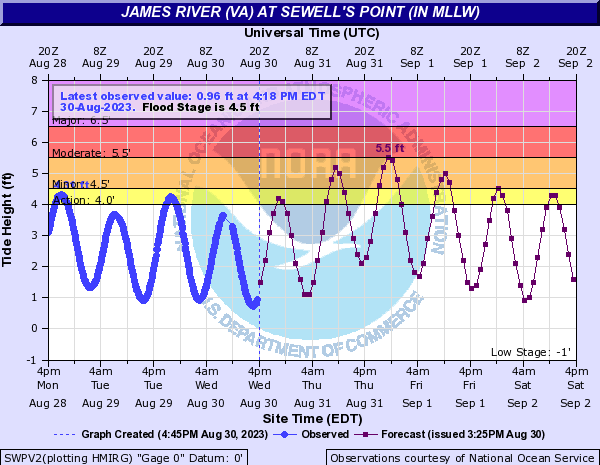
Here is the latest tides chart from Norfolk.
9 p.m. Wednesday, Aug. 30: Most ferry service suspended Thursday
North Carolina’s Department of Transportation Ferry Division has suspended service on most ferry routes Thursday in anticipation of Idalia.
8 p.m. Wednesday, Aug. 30: N.C. schools impacted by Idalia
10 On Your Side has confirmed a number of northeastern North Carolina school divisions that have altered their schedules Thursday in anticipation of Idalia’s impacts in the region.
7 p.m. Wednesday, Aug. 30: Dominion Energy update
Dominion Energy said it would have all hands on deck as Idalia moves into its North Carolina coastal area. It said it had moved 300 additional resources to Hampton Roads and northeast North Carolina to help local crews with power restoration. Crews plan to work 24/7 to restore power as long as it’s safe. To report an outage, use the free Dominion Energy app or call 1-866-DOM-HELP (1-866-366-4357).