The year 2020 is one to remember, a difficult time for many of us, and Mother Nature hasn’t made it any easier. Storm after storm, the 2020 Hurricane Season has been the most active ever.
Captain Ryan Smithies, a U.S. Air Force Hurricane Hunter Pilot knows this first hand, as he and his crew members fly the large C130J directly into these systems. And this year it seemed never-ending, in fact, Smithies mentioned that he had doubled the number of passes through a hurricane this year over what he had last year by the first week of September.
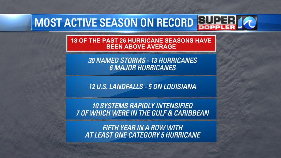
This year racked up 30 named storms, 13 hurricanes, and 6 major hurricanes. There were 12 landfalling systems in the United States, 6 of which were hurricanes. Five systems made landfall on Louisiana’s coastline. It’s the 5th year in a row with at least one Category 5 hurricane, the list of records seems endless. Most notable is the fact that 10 tropical cyclones underwent rapid intensification.
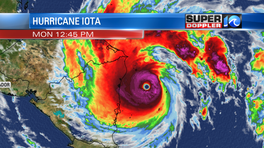
Rapid intensification is when a tropical cyclone increases wind speed by 35mph or more in a 24-hour window. It’s something that used to only happen a few times a year, but now seems to be happening more frequently, and closer to land. Why? There is more energy in the atmosphere.
A changing, warming climate simply means there’s more heat in both the atmosphere and in the oceans. Heat is just a measure of energy, so more heat equals more energy. More energy simply means more extremes.
So the duties of the Hurricane Hunters are vital now more than ever (collecting and feeding real-time data of tropical cyclones, dissecting them so to speak), as the intensity of these systems remains so difficult to forecast. And several of the storms Captain Smithies flew through were on the level of extreme. Take Laura for example, a more memorable mission of his, flying during its rapid intensification process before landfall in Louisiana.
“Whether it’s how the thunderstorms are painting on our radarscope, you know you can see the organization, or just how it feels,” said Smithies. “There may be a pass where you don’t really notice any turbulence, you’re in the eye and the thunderstorms aren’t really organized, and then an hour and a half later, you’re getting rocked.”
Our planet, and especially our oceans, possess a unique energy. It’s one that fuels this power and force, but also one that fuels joy. A joy that some on the East Coast would call, stoke.
“I think it’s really cool that we, as forecasters, have the ability to instill stoke on other people,” said Rob Mitstifer, a surf forecaster for Surfline on the Outer Banks. Just like there are always two sides to every story, there are usually two sides to every extreme, and those that paddle out on the East Coast try to take advantage of that.
Mitstifer grew up surfing in New Jersey, a true East Coast surfer, and studied meteorology because he always wanted to know how waves got good. Now, forecasting with Surfline, he’s able to marvel at large tropical cyclones while providing useful information for fellow surfers to find stoke, as hurricane season can fuel that joy.

Mitstifer explained the ideal tropical cyclone to provide optimal East Coast surf – it’s a large, powerful storm that poses no threat to land, and one that takes a specific path. A path that runs parallel to the East Coast at a slow pace – almost like Paulette, Teddy and Epsilon did this year. These large systems provided fun waves for numerous surf breaks from the Outer Banks to Virginia Beach. And with the way 2020 has been, fun waves were something many were very grateful for.
“It’s not a cliche to say that surfing is therapy for a lot of people,” added Mitstifer. “That we can just go out, get out in the ocean and take your mind off all world events and just have fun.”
So with more energy to create extremes, there’s more energy to fuel the stoke, just as there’s more energy to fuel power and force.
“Don’t take it for granted,” added Smithies. “Just because a storm doesn’t get you this time, you know it’s more a matter of when.”
Hurricane season is half of a year, six months, from June 1st to November 30th – take the time to make a plan. Whether there are 30 storms or just one, being prepared makes those six months a whole lot less stressful.