PORTSMOUTH, Va. (WAVY/AP) — Isaias has weakened to a Tropical Storm as of 5 p.m. on Saturday after it blew through the Bahamas and churned toward the coast. The storm is expected to “re-strengthen” to a hurricane overnight while it approaches the southeast coast of Florida.
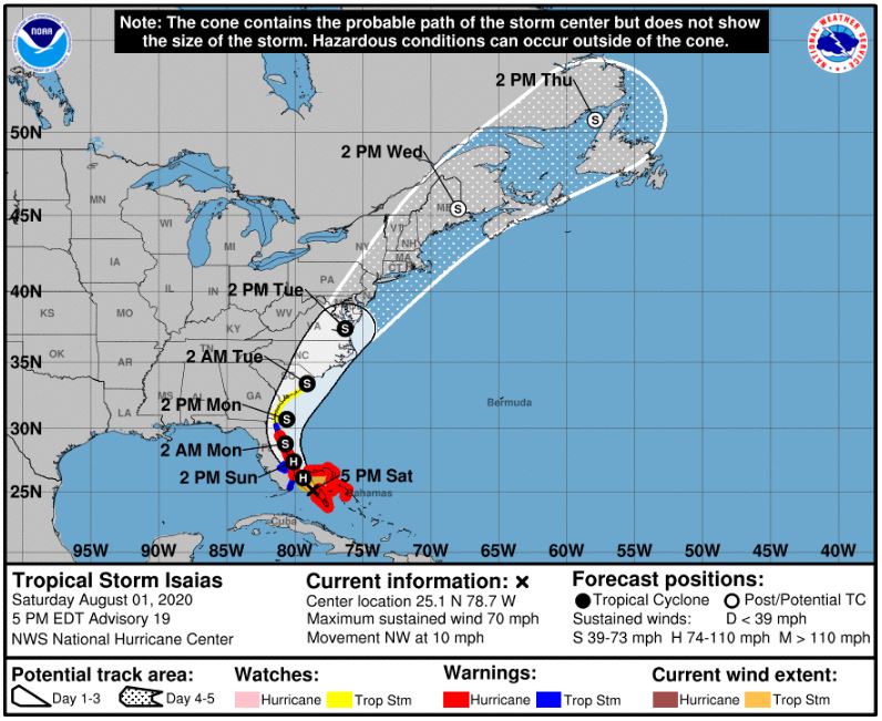
The storm track shows Isaias could hit North Carolina just after 2 a.m. on Tuesday and be above Virginia around 2 p.m. on Tuesday. NWS shows the storm as a Tropical Storm with maximum sustained winds at 70 mph moving northwest up the coast.
The U.S. National Hurricane Center said Isaias had maximum sustained winds of near 70 miles per hour at around 5 p.m. after a decline from earlier in the day.
The storm continues to grow in certain parts. As of 8 p.m. on Saturday, the Coast Guard set Port Condition X-Ray for Port of Virginia.
The impacts of the hurricane on Virginia aren’t certain yet. The storm could weaken as it moves north, and whether it tracks further inland or out to sea will determine whether it is weaker or stronger, respectively.
Further south, Storm Isaias is bearing down Saturday on places where the virus is surging, piling another burden on communities already hard-hit by other storms and sickness. Florida authorities closed beaches, parks, and virus testing sites.
The hurricane ripped shingles off roofs and blew over trees as it carved its way through the Bahamas early Saturday and headed toward the Florida coast, where officials in Miami said they were closing beaches, marinas, and parks.
Isaias had maximum sustained winds of 85 mph (135 kph) Saturday morning and some strengthening was possible later Saturday, the U.S. National Hurricane Center in Miami said. The storm was centered about 50 miles (85 kilometers) south of Nassau in the Bahamas and was moving northwest at 12 mph (19 kph). Forecasters said some decrease in its forward motion was expected.
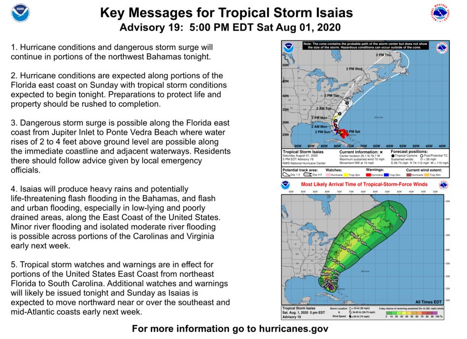
According to the National Hurricane Center, minor river flooding is possible across portions of the Carolinas and Virginia early next week. Additional warnings will likely be issued later today and Sunday along the U.S. east coast as the risk of wind, heavy rainfall, and storm surge impacts continue to increase.
Saturday afternoon, Cape Hatteras National Seashore announced it will be closed Sunday, August 2.
Additional information:
Campgrounds: Oregon Inlet, Cape Point, and Frisco campgrounds will close at 10 a.m. Sunday. Campers with reservations have received notifications via recreation.gov. Ocracoke Campground closed yesterday, July 31.
Beach Access Ramps: All off-road vehicle (ORV) ramps will close at 9 p.m. on Saturday. The ramps will reopen for ORV access after evacuation orders are lifted and post-storm assessments are completed.
Swimming Prohibition: Due to the forecast for life-threatening rip currents along Hatteras Island beaches, Dare County’s state of emergency order includes restrictions on ocean swimming. Rip currents on high-risk days are life-threatening to anyone entering the surf.
Friday afternoon, Governor Roy Cooper declared a state of emergency ahead of Hurricane Isaias for North Carolina — which is projected to go over the N.C. coast around the start of next week.
Virginia Gov. Ralph Northam also declared a state of emergency Friday evening in advance of Hurricane Isaias moving through our region.
“Hurricane Isaias is a serious storm, and current predictions indicate that it may impact parts of Virginia as early as this weekend,” Northam said in a prepared statement in a news release Friday. “This state of emergency will ensure localities and communities have the assistance they need to protect the safety of Virginians, particularly as we continue to deal with the COVID-19 crisis. I encourage Virginians to take all necessary precautions, monitor local weather forecasts, and stay alert.”
The state of emergency allows the state to mobilize resources and equipment that aid hurricane response and recovery efforts.
The governor also says residents need to know the zone they live in, which determines their risk for flooding and other impacts from storms such as Isaias. Review Virginia’s evacuation zones at KnowYourZoneVA.org.
Virginians can also check out the Virginia Hurricane Evacuation Guide During the COVID-19 Pandemic, which outlines preparedness, response, and recovery actions designed to reduce the risk of transmission of COVID-19 and protect public health.
Virginians can follow the Virginia Department of Emergency Management on Twitter and Facebook.
Stay with WAVY.com for updates on the hurricane from our Super Doppler 10 weather team.