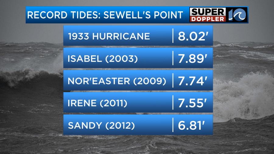
HAMPTON ROADS, Va. (WAVY) — Hurricane Isabel set the benchmark for memorable storms in Hampton Roads for many reasons — claiming many lives, creating widespread power loss and setting the second highest tidal flooding record in modern history.
“We almost compare every hurricane to what the levels were during Isabel,” said Super Doppler 10 Meteorologist Ricky Matthews. “It woke a lot of people up to the dangers of what storm surge can do to this region.”
In the 20 years since Hurricane Isabel, the sea levels in Hampton Roads have risen more than three inches, and while that doesn’t seem like much, it’s not what our infrastructure was built for years ago. As sea levels continue to rise, many experts question what an Isabel-type event would look like today across Hampton Roads, and the expectations are not comforting.
“There’s a whole lot of scientific questions that I think we need to answer to think about what scientifically that looks like in Hampton Roads,” said Dr. Jess Whitehead, director of the Institute of Coastal Adaptation and Resilience at Old Dominion University. “They’re not trivial, they’re not just science projects because it would mean impacts for the people that live here.”
According to NOAA’s intermediate projection for Hampton Roads, in 2040, sea levels will rise an addition 10.5 inches. By 2060, levels will rise another foot-and-a-half.
“So trying to think about what we do in the future and what our communities look like in the future requires some imagination,” Whitehead said. “And it’s not at all going to look like what it does today.”


