Gov. Roy Cooper and emergency management officials provided an update on Hurricane Idalia’s arrival in North Carolina during a 3:30 p.m. news conference on Wednesday. Watch.
KILL DEVIL HILLS, N.C. (WAVY) — A tropical storm warning has been issued by the National Weather Service for the Outer Banks to the Virginia state line ahead of Idalia’s arrival in North Carolina.
The latest forecast calls for equivalent tropical storm force wind, with a peak wind forecast of 30 to 40 mph winds with gusts to 50 mph. The National Weather Service said the window for tropical storm force winds is Thursday afternoon until Friday morning. It said people should now be preparing to protect their property and to prepare for limited wind damage.
Gov. Roy Cooper declared a state of emergency on Tuesday ahead of Idalia’s arrival in North Carolina.
“We hope that it won’t affect North Carolina that badly, but we have to be ready,” said Gov. Roy Cooper. “This is a strong storm that’s continuing to strengthen and it definitely will head North. We just don’t know how much we will experience, the key is to be ready and that’s what we’ve done with this order.”
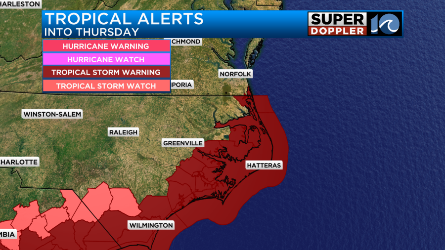
There is also a flood watch in effect for portions of eastern North Carolina, including Hatteras Island, Ocracoke Island, Pamlico and the northern Outer Banks from Wednesday afternoon through Thursday evening, with excessive runoff that could result in the flooding of rivers, creeks, streams and other low-lying and flood-prone locations. It said rainfall amounts could range from two to six inches, with isolated amounts of up to eight inches possible.
The governor’s office made the declaration to activate the state’s emergency operations plan, waive transportation rules to help the transport of fuel and critical supplies and services, help first responders and assist the agriculture industry to prepare in advance for inclement weather and protect consumers from price gouging, the governor’s office said in a media release.
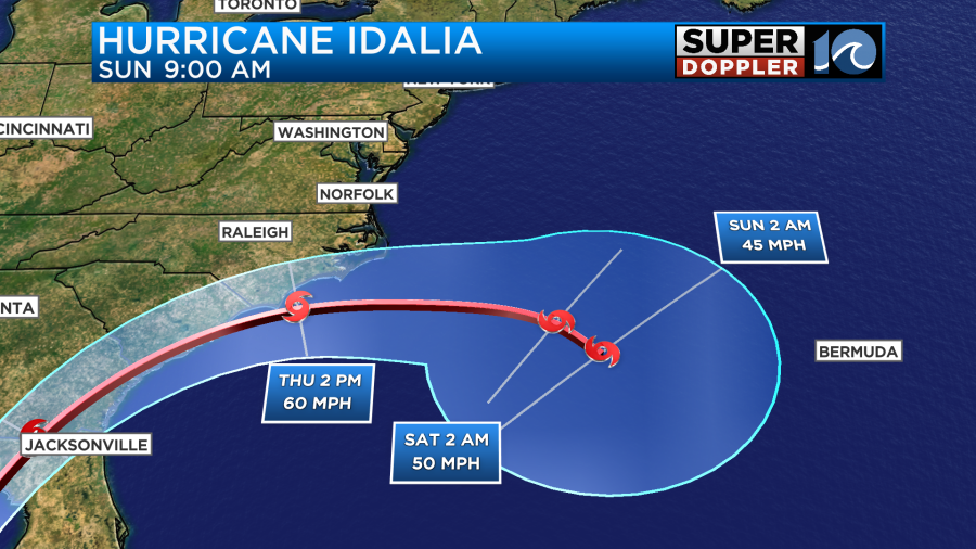
Idalia was expected to bring several hazards to North Carolina on Wednesday and Thursday, with the risk of flooding from heavy rain particularly in the southeastern part of the state.
“We are continuing to monitor Idalia’s course and its potential impacts on our state and it’s critical to make sure we are fully prepared,” Cooper said. “It is important for North Carolinians to gather emergency kits and prepare for the storm before it’s too late. We also want to make sure our farmers are able to protect their crops.”
“We are working together with our local jurisdictions to ensure we have necessary resources staged to support emergency response needs,” said North Carolina Emergency Management Director Will Ray. “We are grateful for the partnership to protect our communities, the 10.6 million North Carolinians, and visitors.”
The governor and state officials advise the following tips to make sure people are personally prepared:
- Have multiple ways to receive emergency information, including watches and warnings. Make sure emergency alerts are enabled on a cell phone and download a weather app.
- Have an emergency plan. Know where to go if there’s a need to evacuate. Make a plan to stay with family, friends or at a hotel. Public shelters should be a last resort.
- Gather some emergency supplies or refresh an emergency kit. Visit ReadyNC.gov for info on how to build an emergency kit.
- If people live near or are visiting the coast, be aware if you are located in a coastal evacuation zone. Visit KnowYourZone.nc.gov to see if you are located in a pre-determined evacuation zone. Learn your zone and listen for it if evacuations are ordered by local governments.
- Never drive through flooded roadways. Turn around, don’t drown.
Visit ReadyNC.gov for additional information on weather preparation, as well as information on power outages. Visit DriveNC.gov for current travel conditions from NCDOT.
Lifeguards on the Outer Banks are encouraging people to stay out of the water unless they’re experienced swimmers or surfers.
“It’s pretty obvious it’s dangerous right so really what we’re looking at with the hurricane swells is the shoulder of the hurricane swells where it’s still pretty small, it’s pretty inviting, this morning the sun was out and it’s really when more people are in the water they have a greater chance of somebody being swept away,” said Kill Devil Hills Assistant Ocean Rescue Supervisor Ben Battaile.
Battaile says on Monday, lifeguards in Kill Devil Hills had to rescue three people.
“Watch your little ones,” Battaile said. “People can get in the water all day today if you’re a surfer, if you’re body boarding with fins, if you have good floatation or you’re a strong swimmer, for them the ocean’s a playground.”
Battaile says he’s hoping they’ll be able to lift the red flags by the end of the week, but says it depends what Hurricane Idalia brings.
But vacationers like, Joey Pearson, aren’t letting it impact their trip.
“We’ve been vacationing here every year for ten years and I’ve never seen a no swimming flag when we’ve came,” Pearson said.
Pearson spent the day fishing on Avalon Pier with some family and friends.
But lifeguards say it’s important if you do get stuck in a rip current to try to float and wave for help.
“Remain calm, maybe wave for help and if you are a strong swimmer, try to swim toward a sand bar or try to swim toward shallow water that’s near by you can tell where there’s shallow water by breaking waves and white water,” Battaile said.
Due to swells produced by distant Hurricane Franklin and elevated tides, the National Park Service says some Seashore oceanside beaches are experiencing erosion and overwash.
Cape Hatteras National Seashore’s Ocracoke, Cape Point and Frisco campgrounds will close on Wednesday and will re-open after Idalia passes.
If you’d like to sign up for OBX Alerts, click here.
Weather Cancellations
Schools
Dare County Schools has announced that Thursday will be a remote learning day due to severe weather, and Friday will be an optional workday, not a student day. It said that students and staff will receive further instructions from their school Wednesday.
It said that based on information from the National Weather Service’s 6 p.m. Tuesday webinar, Idalia is on the same path to pass south of Cape Hatteras, and “it appears the storm will slow after moving off the coast (and) rainfall estimates have increased.”
It said ocean over wash estimates have increased from one to three feet.
Northampton County Schools announced they’ll close at 1 p.m. Wednesday due to pending inclement weather from Idalia. They’ll also have a two-hour delay on Thursday morning.
Cape Hatteras National Seashore
In addition to a forecast of heavy rainfall, strong winds and other negative impacts from Idalia on the Cape Hatteras National Seashore, some Seashore oceanside beaches are already experiencing erosion and overwash from distant Hurricane Franklin and elevated tides. Portions of off-road vehicle routes may be impassable until the weekend.
The Seashore’s Ocracoke, Cape Point and Frisco campgrounds will close on Aug. 30. Updates and any additional closures will be listed on the Seashore’s alerts and conditions webpage.
Seashore visitors should stay out of the ocean until conditions improve because of life-threatening rip currents. Go to www.weather.gov/beach/mhx for the latest beach conditions forecast.
A two-mile stretch of beach between the north end of Rodanthe and South Shore Drive in Rodanthe should be avoided because of of vulnerable houses that may be damaged by rough surf and strong winds.
Seashore visitors can monitor road conditions at https://drivenc.gov, call 252-996-6000 or 6001 for current information on ferry services to and from Ocracoke Island.
Ocrafolk Opry
The Ocrafolk Opry scheduled for August 30, 2023 is canceled because of the impending storms.