HAMPTON ROADS, Va. (WAVY) – If you’ve ever tried to get around Hampton Roads in a bad rainstorm, you know it’s not easy.
There’s flooding everywhere, and it’s expected to get worse with climate change.
But now, technology on your smartphone can help you navigate around the trouble spots when things get nasty.
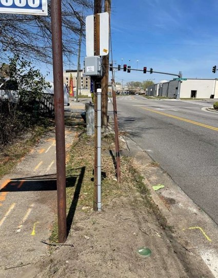
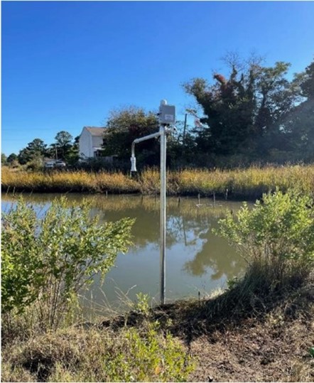
The Hampton Roads Planning District and the travel app Waze partnered to install 20 new sensors on roads across the region from Virginia Beach and Norfolk, to Hampton and Newport News.
That technology will sense flooding and send updates on travel conditions every five minutes.
“This is hopefully a very easy interface for lots of people to get the information they need,” said Whitney Katchmark, principal water resources planner with the Hampton Roads Planning District Commission.
The information you need about flooded roads – straight to your finger tips.
“We tried to get the most problematic intersections in our pilot program,” Katchmark said.

Katchmark said they got a $200,000 grant from the U.S. Department of Defense’s Office of Local Defense Communities Cooperation to help get this project off the ground, mainly because of all the military installations we have in our area.
“We picked 20, and we picked 20 that are across the region across seven localities and we also picked some that are on typical paths for military commuters,” Katchmark said.
She explained the rationale behind the sites of the sensors.
“We’ve got port traffic we’ve got military folks who haven’t lived here very long. we’ve got tourists,” Katchmark said. “We realize that delivering this information in a way that’s publicly and commonly used is much better than saying you need to sign up for this list serve (or) you need to go to this website.”
Katchmark said that if the sensor detects at least two inches of water it’ll pop up as an alert.
It also measures the depth of water and can be used by scientists for flood predictions. They hope it’ll make for a safer commute as the region works on resiliency.
The sensors are placed at the following locations:
- Portsmouth: South Street (by Chisolm Circle)
- Portsmouth: London Boulevard (by Ruth Brown Way)
- Portsmouth: Rodman Avenue (between Western Branch Blvd and King)
- Portsmouth: Clifford Street
- Virginia Beach: Sandbridge Road (at Lotus Pond)
- Virginia Beach: Princess Anne Road (at West Neck Creek)
- Virginia Beach: Virginia Beach Boulevard (east of Dukes Lane)
- Virginia Beach: Shore Drive
- Hampton: Charlton Drive
- Hampton: North 5th Street (by the creek)
- Newport News: 202 Buxton Avenue
- Chesapeake: Battlefield Boulevard at Great Bridge
- Chesapeake: Cedar Road
- Chesapeake: Mt. Pleasant Avenue (at Butts Station)
- Chesapeake: Dock Landing Road
- Norfolk: Monticello Avenue (at the 9th St. intersection, Fort Tar Lane)
- Norfolk: Hampton Boulevard (at Lexan Avenue)
- Norfolk: Llewellyn Avenue (between Delaware Avenue and Connecticut Avenue)
- Norfolk: West Olney (at the Boush Street intersection)
- Poquoson: Poquoson Avenue (at N. Lawson Road)
Click here to view an interactive map of the sensor locations.
“Our hope is to have sensor data where it’s useful,” Katchmark said, “and as localities are trying to fix all of these flooding issues, this is sort of a band-aid. As we work to get things fixed, at least you can know where the problems are. You can spare yourself the headache of being stuck in areas where there’s a flooded road.”
To download the Waze app, go to the Apple Store or the Google Play Store.