NORFOLK, Va. (WAVY) — The City of Norfolk is bordered by multiple bodies of water and more than 200 miles of riverfront and bayfront property. Flooding is inevitable. On Thursday, the city hosted the first of four informational sessions on flooding.
“Folks are seeing the flooding more frequently and we’re seeing that in the data,” said Kyle Spencer, chief resilience officer for the city of Norfolk.
The sessions are part of a citywide effort to explain, educate and receive feedback.
“We’re trying to tackle it from all different angles,” Spencer said.
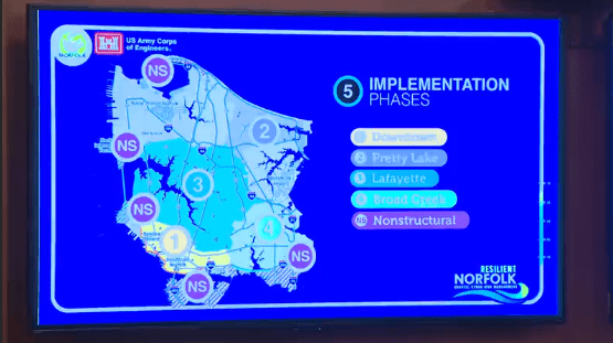
Initiatives like Coastal Storm Risk Management, a $2.6 billion project made up of storm-surge barriers, nine miles of floodwalls, 11 tide gates and 10 pump stations to decrease Norfolk’s flood and storm damage risk and the St. Paul’s Blue Greenway to treat and store stormwater runoff.
“Everyone knows when we get a lot of rain in a short amount of time, it floods,” said Michelle Williams of the city’s Division of Environmental Stormwater. “Especially if it’s high tide, because we have water coming back up through our storm drain system.”
There are also steps you can take to minimize risk.
“Keeping yard debris out of the curb line, grass clippings,” Williams said. “Things like scooping the poop in your own yard or preventing stormwater pollution from fertilizers going into the storm drains, because anything that goes in our storm drains ends up directly in our rivers.”
Those who attended were also reminded of the city partnership with the Waze app when navigating flooded roads and where they could find their property zone in case of the need to evacuate ahead of a hurricane.
“We try to cover the whole spectrum of problems throughout the city,” Spencer said.
The city has three more flood strategy open houses:
- March 19: East Ocean View Senior Center, 9520 20th Bay St.
- March 21: Jordan-Newby Anchor Branch Library, 1425 Norchester Ave.
- March 25: Lambert’s Point Community Center, 1251 W 42nd St.


