(WAVY) — As the sea level rises across the world, the land in Hampton Roads is sinking, and in some locations, sinking faster than the rising sea.
A new study out of Virginia Tech highlights the elevated risks of flooding in Hampton Roads, and across the East Coast, due to land subsidence. The 15-year study asked the simple questions —where is the land subsiding and by how much.
To the researchers surprise, nearly the entire U.S. East Coast is experiencing subsidence.
“For a person standing on the coast, it doesn’t matter if the sea goes up or the land falls, the effect is the same,” said Dr. Manoochehr Shirzaei, an associate professor at Virginia Tech who conducted the study. “So in the near future, five, 10 or 15 years, the hazards that some communities will face will be because of subsidence, not sea level rise.”
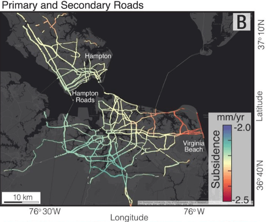
Across Hampton Roads, the rate of land subsidence ranges from 5mm to 7mm annually. And with the current rate of sea level rise sitting at 3.5mm annually, that means in parts of the area, the land is sinking twice as fast as sea level rise.
Land subsidence can be attributed to what’s called glacial isostatic adjustment, which, simply put, is the land under our feet adjusting to the lack of weight, due to the lack of ice that was once there nearly 16,000 years ago during the last ice age.
However, that’s all natural and has been ongoing for centuries. According to Shirzaei, that’s only part of it. The remaining 70% to 80%, Shirzaei points towards groundwater pumping and infrastructure limiting sediment from reaching the coastlines.
“Groundwater pumping can be mitigated almost entirely,” Shirzaei said. “If you manage to find a way to increase the supply of water, say through rivers or treating wastewater, and that can reduce subsidence, it’s doable.”


