We are going to enjoy a streak of sunshine for the next few days. Today we have high pressure settling in from the west. The area of low pressure in the Northeast has moved offshore.

There were lots of clouds in the region last night, but they have moved out this morning. We’ll have a lot of sunshine through the day.

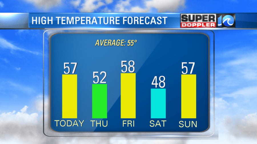
The wind will be out of the west/southwest at 5-15mph. It won’t be too strong, but it should help to warm us up a bit this afternoon. High temps will rise to the mid-upper 50s with a couple of 60s inland/south. It will be more in the lower 50s north/northeast of Hampton Roads.
Tomorrow high pressure will still control the weather. So we’ll still have lots of sunshine. The breeze will turn a little more out of the northwest. That will cool down temps a little. Highs will be more in the lower 50s. We’ll be mostly dry on Friday, but a stray shower will be possible. Highs will be in the upper 50s. Then we’ll drop temps on Saturday to the upper 40s. We’ll be dry but seasonably cold.

We’ll warm up to the upper 50s again on Sunday. However, we’ll have increasing clouds with some isolated pm showers. Then we’ll have a lot of rain coming in early next week as a big area of low pressure forms to our west. At least it will be warmer. Highs will be in the upper 60s.
Meteorologist: Jeremy Wheeler


