Update: Thursday Afternoon
So… where’s the rain!? On the way… eventually.
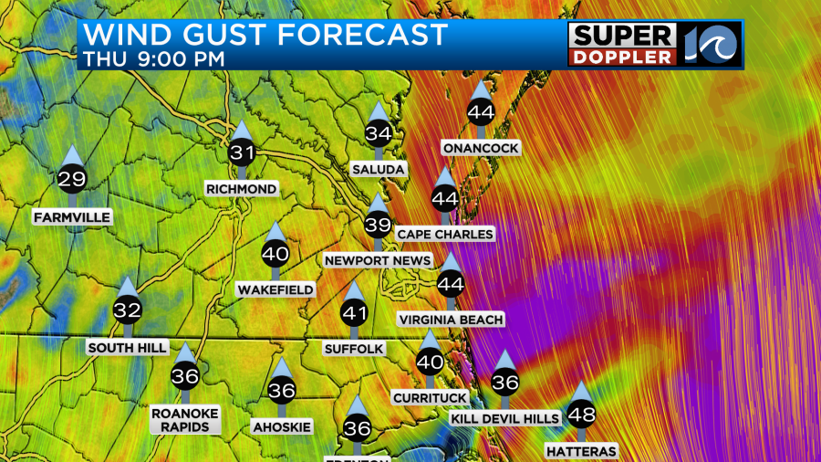
Main story for the rest of our afternoon and evening will be the wind. By this evening we’ll see wind gusts to around 35-40mph, especially around the waters edge. Minor tidal flooding along the Albemarle Sound and in Pungo could be possible due to the persistent wind.
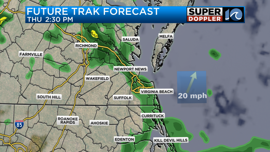
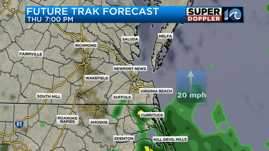
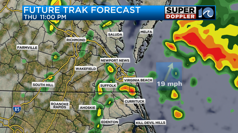
It may not be until after sunset that widely scattered showers develop around the region. Late tonight, pushing midnight we’ll have a round of scattered showers, downpours and a few strong thunderstorms blow through the region.
The system moves across the region very quickly so the weekend shapes up quite nicely. Expect some stubborn clouds on Friday with a stray shower here or there. Temepratrues will hold near 70° as the morning breeze slowly backs off. It’ll be much calmer for the rest of the weekend with sunshine taking over. Near 70° on Saturday with mid/upper 70s on Sunday – get out and enjoy!
-Steve
______________________________________________________________________________________________________
This morning we had lot of clouds in the area, but there wasn’t much rain.
We have had a lot of moisture move into the region over the past couple of days. We’ve also had some warm temperatures enter the area. Today we will be in a large zone of warm and humid air. A warm front is to our north. A cold front is to our west. There is also a strengthening area of low pressure over the Tennessee River Valley.
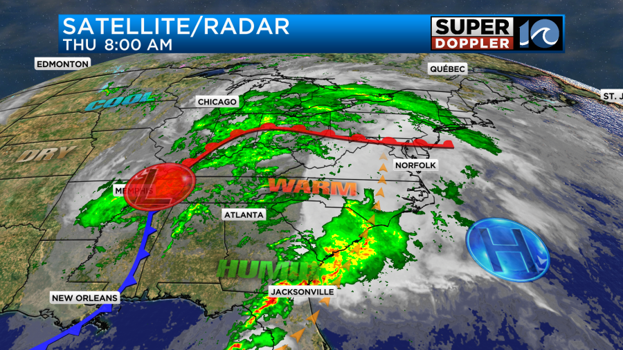
We are going to hold onto a lot of clouds through the entire day with a few peeks of sun. However, we’ll also have an increasing wind out of the south. It will run at 10-15mph with gusts to 20mph this morning. Then it will increase to 10-20mph this afternoon and evening with gusts to 35mph. There may be a few gusts to 40mph near the shore this evening.

These winds will push our high temps up to the mid 70s despite the clouds and the increasing chance for rain. We’ll have scattered showers with a few storms this afternoon. Our Future Trak model shows one big band of rain moving up from the south, but the High Resolution Rapid Refresh (HRRR) model shows a lot of coverage over most of the region.

I think it will be a little bit of in-between the 2 models, but I do favor the wetter models for now.
Either way we’ll either have on/off showers and some storms from the afternoon into the evening, or we’ll have a couple more rounds of showers and storms like our model suggests.
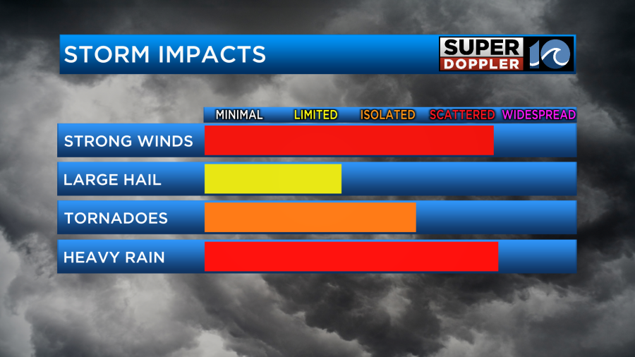
There will already be some strong winds out there even without any thunderstorms. So there will easily be a low threat for some severe winds this evening. There isn’t going to be a lot of instability, but there will be a lot of wind shear (increasing winds with height). So we have a marginal risk for severe here.

There will be a higher risk to the west as it will be closer to the surface low. That is also where there will be a higher risk for tornadoes. Our local chance is rather low but not zero. The chance for hail is also pretty low.
After midnight we’ll have the winds turn out of the west, and this will gradually pull in some drier air.
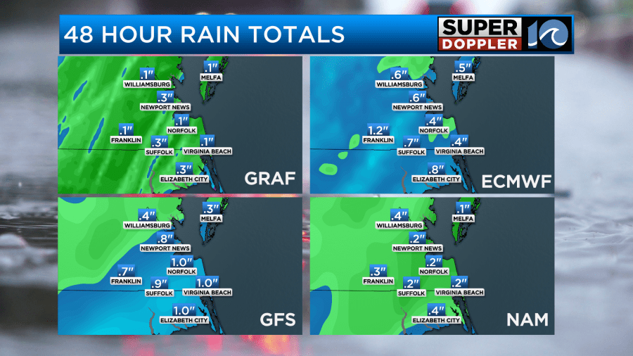
The models really vary as to how much rain we are going to pick up. I think our model is underdone while the GFS is overdone.
The rain won’t be done on Friday, but there won’t be much. There may be an isolated shower early in the morning as the cool front moves offshore. However, that will go away by mid morning. Then we’ll have some sunshine for a while before the clouds increase again. An upper level low will bring us scattered clouds and spotty showers tomorrow afternoon.

These showers won’t add up to hardly anything in the rain gauge. Winds will still be breezy out of the west. Gusts will be up to 25-30mph. High temps will be in the low 70s. THEN….we’ll have a great weekend as high pressure builds back in. We’ll be mostly sunny on Saturday with highs near 70 degrees. We’ll be mostly sunny with high temps in the upper 70s on Sunday.
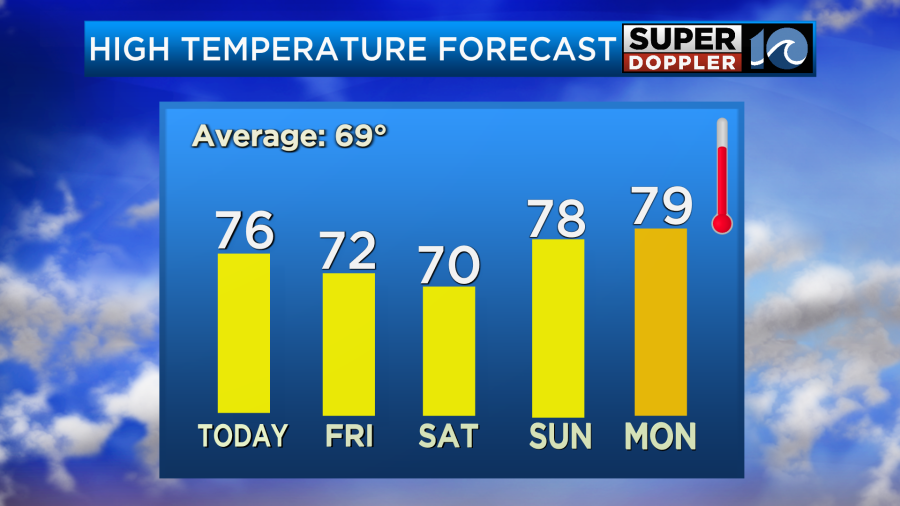
It looks like we’ll not only stay warm, but we’ll warm up even more next week. High temps will run in the 80s for at least a couple of days.
Speaking of warm temps. Recently, NASA put out an article about sea level rise. Apparently, there was a small spike in the water levels due in part to the recent strong El Nino. The spike is recent, but the overall upward trend is long-term. Here is the article with more information: Small spike in water rise.
One problem that is looking more likely is that the 2024 hurricane season could be very rough. El Nino is forecast to break down, and the tropical water temps are running way above average. There’s been a lot of talk about this, and I completely agree. Hopefully, we are wrong! Here is one article with more information: Possible super busy hurricane season 2024.
Meteorologist: Jeremy Wheeler


