BREAKING NEWS: Tropical Storm Ophelia officially formed Friday afternoon, and is expected to bring heavy rain, storm surges and strong winds to our region. Updates from the National Weather Center.
First things first. Let’s talk about the elephant in the room. What is this thing that is affecting our region today? Is it a “potential tropical cyclone,” a tropical storm, a nor’easter, a hybrid? I’m here to tell you that it’s not a clear answer.
If I had to label it in a couple of words I would say that this is a developing “hybrid system.” It is going to have some tropical characteristics with some warm air and thunderstorms near the center. It will have a defined area of low pressure. There will be some minor storm surge.
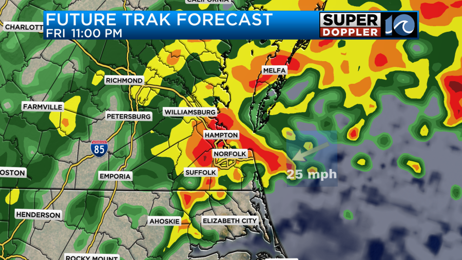
However, the low is interacting with a front. Cooler air will also wrap into the center at times. Plus, the effects are being felt far from the center of the storm. That’s important this time. Here is the track of the storm system, but I’ve also added the forecast model.
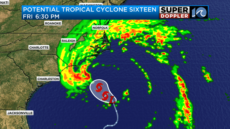
Notice that the rain will reach far from the center of the storm. The wind will also be increasing well ahead of the storm. So I won’t say that the track is unimportant. However, it isn’t as important as most of our previous systems.
This morning the low formed along a stationary front well to our south.

Due to overunning, we have already had some light rain in the region.
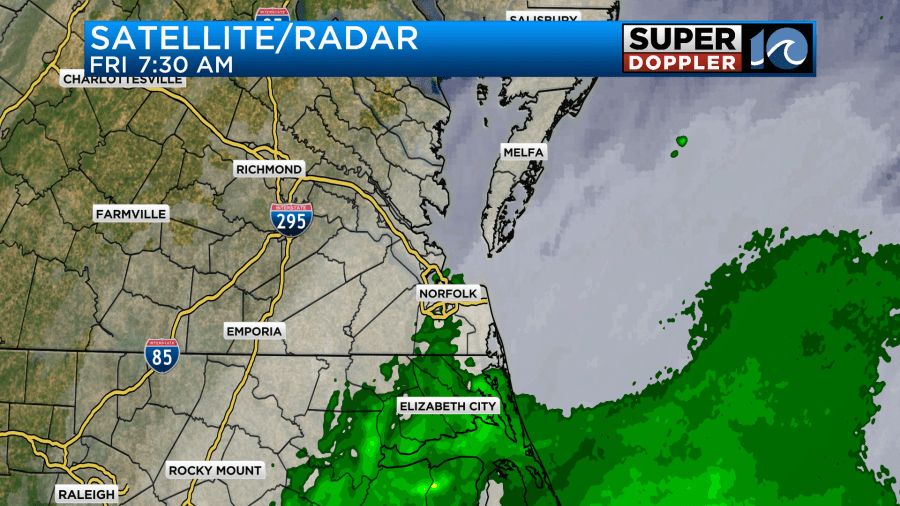
Remember, overunning precip happens when warm and humid air pushes up over a cooler air mass. This basically creates a lot of forced condensation which then leads to rain. That process is why we’ll have a lot of rain today. The moisture will increase at the surface, but it will really increase at all levels. Rain will increase this afternoon, and it will become widespread.

Rain will be widespread this evening during the PM Commute, and it could be heavy in many places.
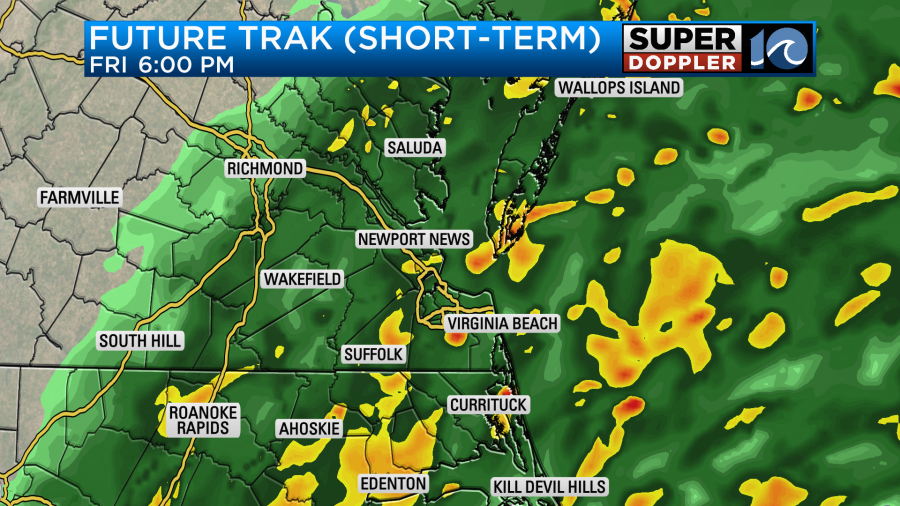
Wind will also be increasing. During the daytime it will be out of the northeast at 15-20mph with gusts to 30mph. There will be a few higher gusts near the shore.

By the evening hours the wind will increase even more. We could have some gusts 30-35mph in the metro. Gusts could be to over 50mph along the Outer Banks.

This could lead to some power outages over the region.
There may be some minor tidal flooding this afternoon. That will create poor drainage.
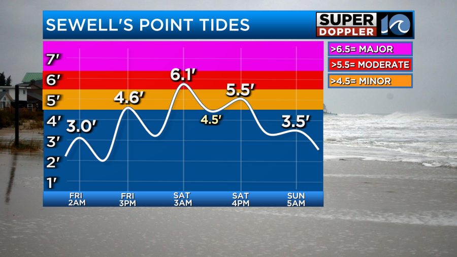
The tidal flooding shouldn’t cause too many problems by itself, but the poor drainage will be an issue. Plus, there are already some high waves from Nigel (which is no longer tropical) along the oceanfront.
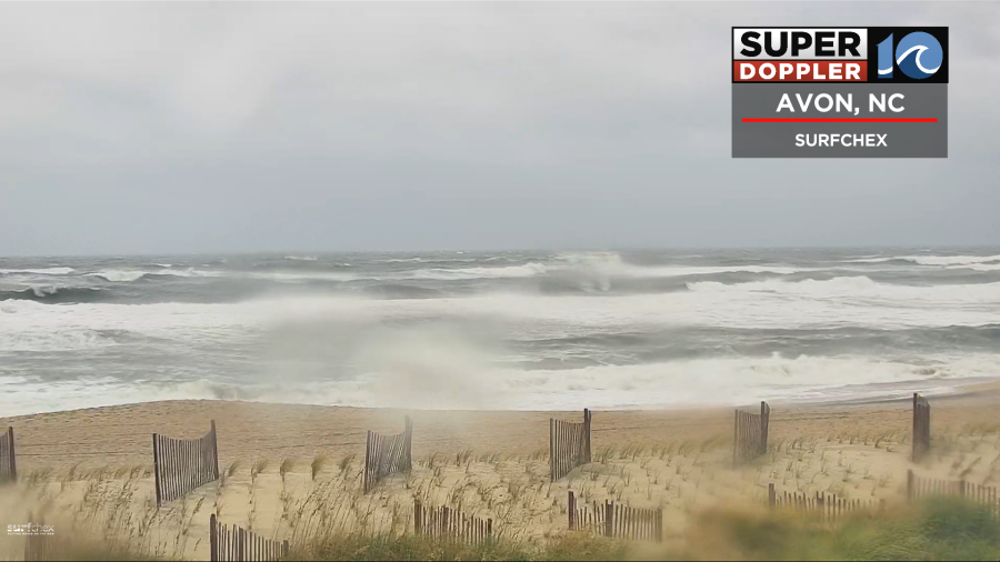
This could lead to some ocean overwash this afternoon. The higher oceanside tide along the Outer Banks will be this afternoon.
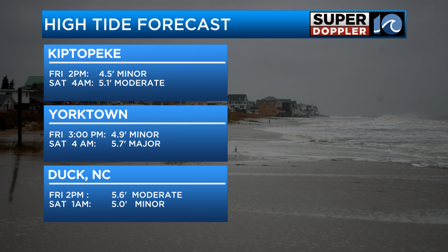
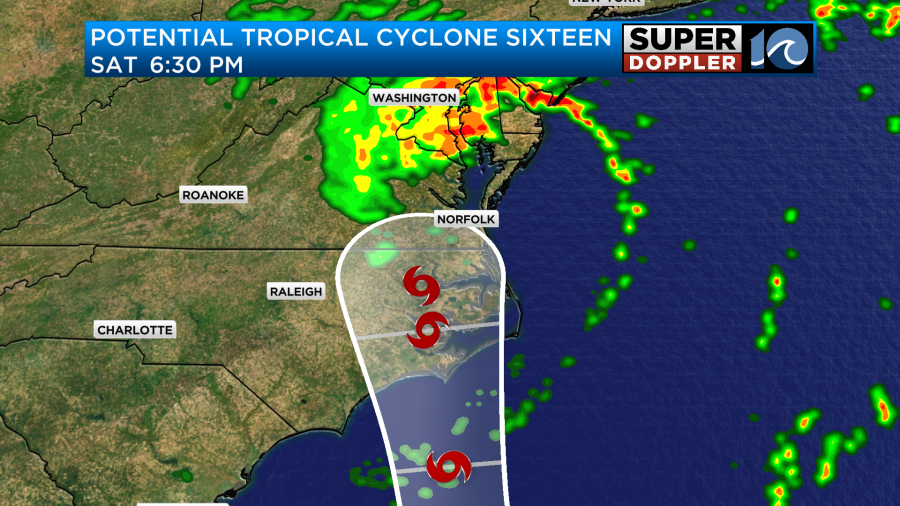
However, the higher tide over the lower to middle Chesapeake Bay will be tomorrow morning between about 2-4am. Luckily there won’t be too many folks on the roads, but this will be some solid moderate tidal flooding. After that point the low will move through the area, and it will change the wind direction. So the Saturday afternoon tide shouldn’t be as high. However, it could be higher on the sound-side of the Outer Banks during that time.
So back to the rain. Overnight we’ll have lots of heavy rain. There will be a few thunderstorms as well, but they shouldn’t be too common. However, some of the rain bands will be pushing up from the south late tonight into early Saturday.
There will be some broad rotation from the storm itself, and this could get focused on some of those bands. This could lead to some quick spin ups or isolated tornadoes overnight into tomorrow morning. Therefore, there is a slight risk for severe weather over most of the viewing area.

The storm system will steadily work through the region during the day tomorrow. Rain will wrap around the center. If you read yesterday’s weather blog, then you know that Future Trak previously ended the rain by Saturday afternoon (I was doubtful), but most of the other models kept the rain going. Now our model has the rain continuing into at least the early to mid afternoon.
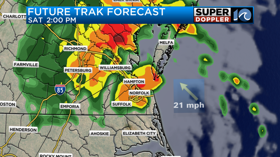
It does have the rain moving out by the late afternoon and evening, and the other models are basically the same. However, there could be a few spotty showers lingering into Sunday morning as moisture wraps in behind the low.
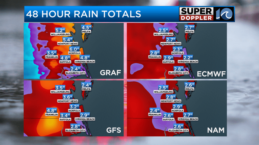
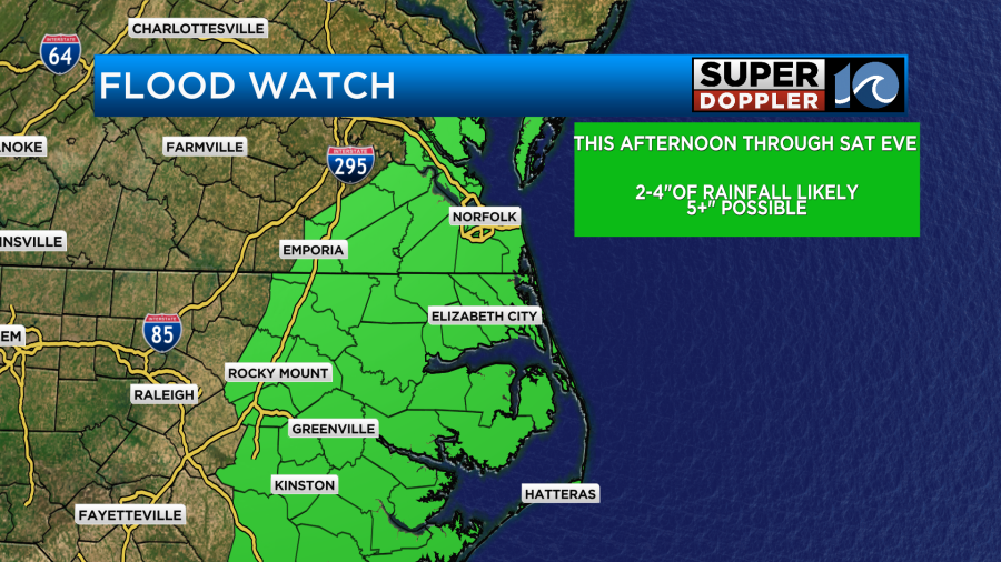
The models are in pretty good agreement for the rainfall totals. It looks like we will get about 2-4 inches with some locations getting 5-6″.
This could create some flooding by itself, but that will be more of a problem during high tide when there will be poor drainage. There is a Flood Watch in effect.
High temps today will only be in the low 70s.

We’ll be in the mid-upper 70s tomorrow if we do get a little sun to pop out. We’ll be in the 70s for the next few days with one or two days hitting 80.
On a lighter note…tomorrow is the first day of Fall. Luckily we’ll have some Fall temperatures to start the season.
Meteorologist: Jeremy Wheeler


