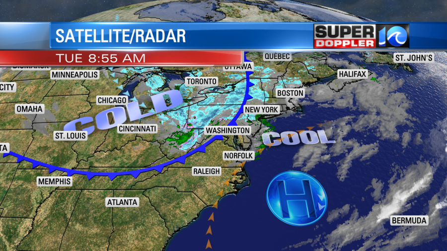
We have a shot of cold air on the way. It’s long overdue. Normally, we would have at least had a widespread frost over the region by now. However, the frost & scattered light freeze we had about a month ago (or so) was followed by a long stretch of mild temperatures. We’ll still be mild today, but then a cold front will move into the region, and it will bring us some seasonably cold air for about 36 hours.
This morning the cold front was still to our northwest. We had a southwest breeze at the surface around an area of high pressure that was offshore.
We’ll warm up for a while through the mid afternoon. High temps will run up to near 60 degrees. We’ll have a lot of sunshine to help boost the temps. However, when the front arrives there will be some more pockets of clouds. There could be a few pockets of drizzle, but it’s so dry that I think it would be virga instead. Remember that is when rain falls, but it evaporates before it hits the ground.

Temps will fall back to the 50s during the late afternoon. Winds will pick up out of the northwest. They could gust to 30mph.
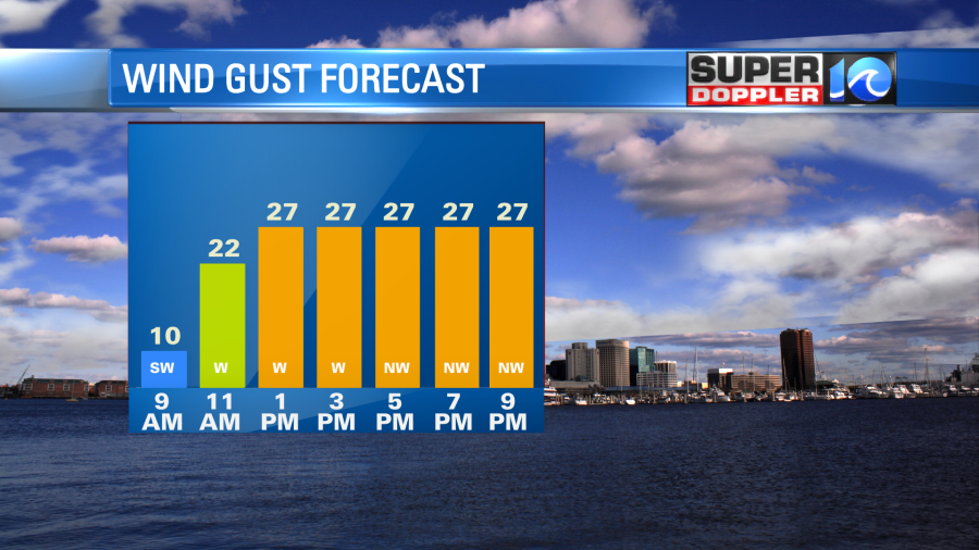
Tonight we’ll have mostly clear skies and northwest winds. Where the winds lighten up, the temps could fall to the freezing mark. There is a freeze warning in effect for some inland & western locations. However, patchy frost will be possible in some places in the metro. This will greatly depend on the wind. Remember, bay temps are in the low 60s right now. So a light breeze off of the bay would keep overnight temps up near the shore into the 40s. Regardless of where we start the day tomorrow, temps will stay chilly through the day. We’ll have mostly sunny skies, but the wind will be persistent out of the northwest. So high temps will only be in the upper 40s to near 50 Wednesday.

We’ll possibly be even colder Wednesday night. If the wind lets up, then that could allow temps to fall to the low-mid 30s over a larger area. Either way we’ll warm up to the upper 50s by Thursday afternoon. Then upper 60s Friday and Saturday. We’ll be dry all the way through the weekend.
Last night hurricane Iota made landfall as a category 4 hurricane not to far from where hurricane Eta made landfall (northeast Nicaragua) 2 weeks ago. Iota moved inland and weakened through this morning.
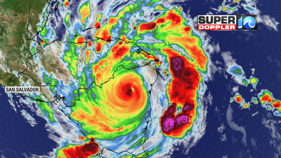
It will continue to move west and weaken into tomorrow. The winds will grind down as it rolls across the higher elevations of Nicaragua and Honduras.
However, it will still dump a lot of flooding rains over the region. This will move west into El Salvador. The damage could be similar to what Puerto Rico endured in 2017 with hurricanes Maria and Irma. Though flooding could be on a larger scale.
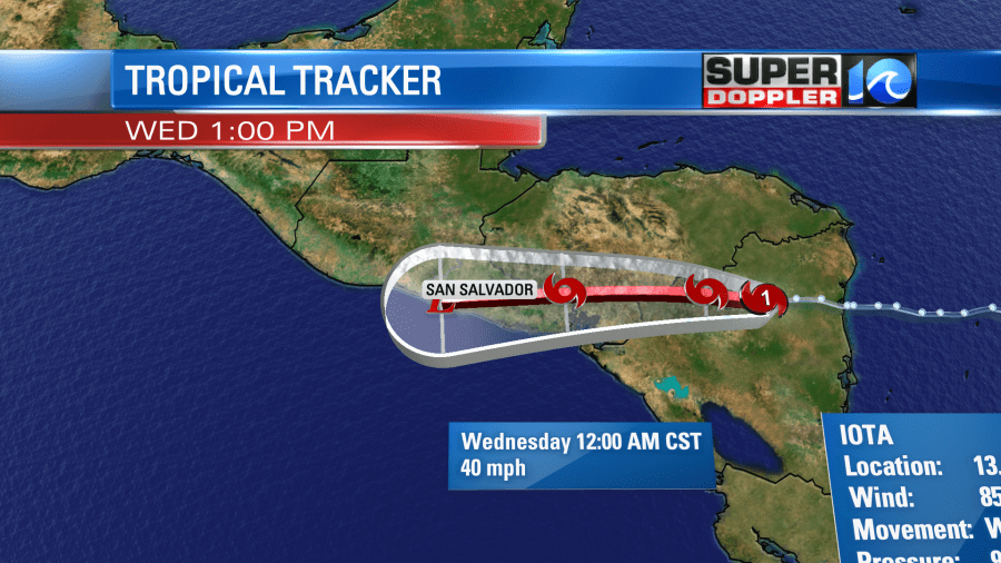
I hate to say it, but there is another tropical disturbance to the east of Iota.
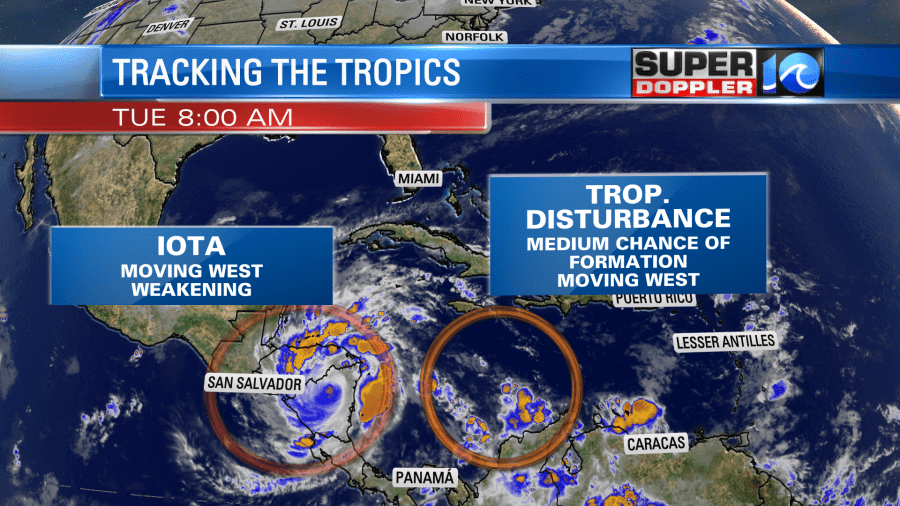
it is moving to the west/southwest. It has a low-medium chance of formation over the next few days. Let’s hope it just stays disorganized. At least it would likely move to the south of where Iota and Eta hit. Stay tuned for updates.
Meteorologist: Jeremy Wheeler


