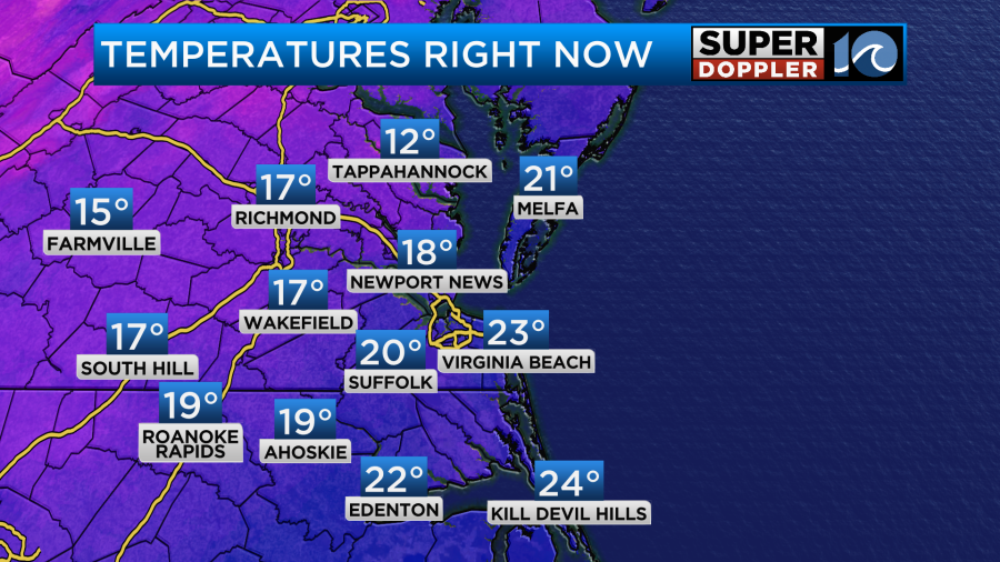
Today we will have some of the coldest weather that we’ll have felt in months. We started off with sunshine, but we also started off with temperatures in the teens and 20s.
A strong cold front has finally made it to our south. High pressure is also building in from the west.

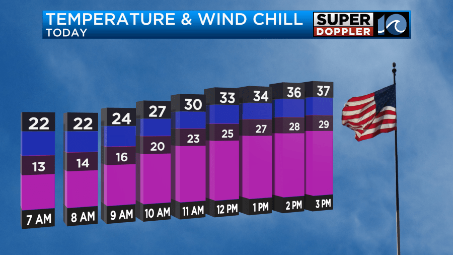
Through the day it is going to be tough to warm up. We will have a lot of sunshine. The air is very dry with dew points in the single digits.
There will be a light (but steady) west/northwest breeze. It will run at 8-12mph. This will be a steady stream of cold/dry air. While this won’t be too strong. It will still have an affect on the “Feels Like Temperature”. Temps will rise into the mid-upper 30s this afternoon. However, wind chills will be in the teens this morning and 20s this afternoon.
Tonight we’ll have more cold air in place. Lows will drop down to the 20s with a couple of teens inland. We’ll be mostly clear with a light southwest wind. It will be another night to slow-drip the faucets. Tomorrow we’ll start off cold again, but we’ll warm up in the afternoon. High temps will rise to the upper 40s.
We will still be dry at the surface, but moisture will increase overhead. Clouds will also increase. There won’t be any precip through the day though. Moisture will continue to increase at all levels going into Friday morning. At that point an area of low pressure will also be moving in from the west. There will be scattered rain showers in Hampton Roads and some mix. However, there may be some light snow to the north/northwest of the metro.
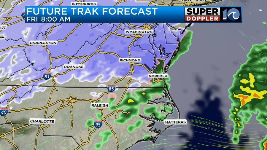
Despite lots of clouds we should be able to warm up to the 40s during the afternoon. Probably into the low 40s. However, it will probably be in the 30s north/northwest of Hampton Roads. This could allow for snow to fall in those areas for a time. I do think the rain/snow line will move north a bit in the afternoon, but we’ll see how far north it gets. Here is Future trak Friday afternoon.
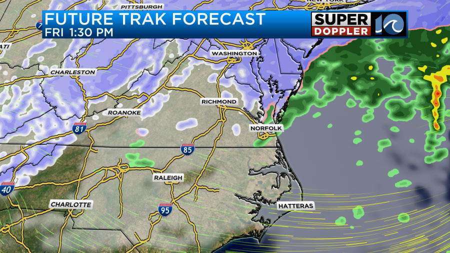
Even if temps are cold enough for snow aloft, the surface temps may be just above freezing for much of the day (again…north and northwest). So the snow may be melting for a long time. It will probably be mainly cold rain showers with a mix in the metro. It may end as some flurries in the evening, but we’ll be drying out during that time as the low moves offshore.
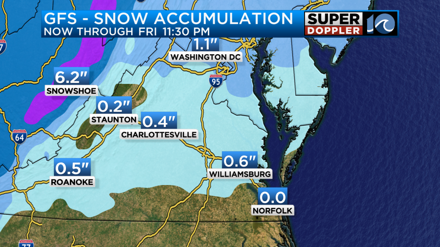
We could see some light accumulations in the typical areas. The latest models are focusing on a line from Williamsburg to Gloucester to Melfa and points northward.

The GFS model is in agreement with Future Trak, but an earlier run did have some light snow in the metro.
It’s still early, and I’m sure that the details will change. So check back for updates. We still have some time.
I am pretty sure that we will get another blast of cold air next weekend. High temps will only be in the 30s both days. Both days do look dry. In the long term I’m seeing a big warmup across the U.S. I wouldn’t be surprised if we hit some 60s and maybe even some 70s later next week.
Meteorologist: Jeremy Wheeler


