
Yesterday was pretty rough outside. High temps were solidly in the 90s. The heat index was between 103 and 110 in the afternoon.
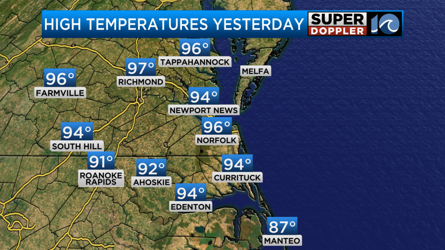
I will say that there were some clouds in the morning that (I think) stopped the temps from reaching the upper 90s in the afternoon. However, the heat indices were still rough as the dew points were well into the 70s.
Today we’ll start to see some changes. We are still going to be very hot and humid. High temps are aiming for the mid-upper 90s.

The heat indices will be between 104 and 109 degrees.

So it will be fairly like yesterday, but there will be 2 differences. The first difference is that we will have a pretty steady breeze out of the southwest. It will run at 10-15mph with gusts to 20mph. The second difference is that high pressure is not as strong nor close. So we are expecting some scattered showers and storms later this afternoon into the evening.

The chance for rain is about 40%. In fact, we could have a few strong to severe storms later today. Part of the region is under a slight risk for severe.

Some of these storms may cool down a few areas. These storms are not from any fronts. The cool front is still over the Midwest today.

As the front arrives tomorrow we will cool down, but the trade-off is that we could have some real heavy downpours. At least the high temps will only be in the upper 80s to near 90.

Keep in mind that the heat index will still be in the mid 90s. The front will be running into the high moisture content along the east coast. So many of the models do show heavy rain forming.

We may have a few showers in the morning, but several clusters of thunderstorms are forecast between Thursday afternoon and Thursday evening.

The latest thinking is that the cool front will sink just to our south on Friday. This will hopefully lower the temps, humidity, and cloud cover just a little more. It could also lower the rain chances for southeast Virginia. There will still be a few storms possible, but the higher chance should drop into North Carolina closer to the front.

It’s possible that most of Friday could be a decent day (in Virginia), but I’m hesitant to put a stamp on it as these Summertime fronts can be notorious for wobbling and moving more or less than forecast. High temps will be in the mid 80s.
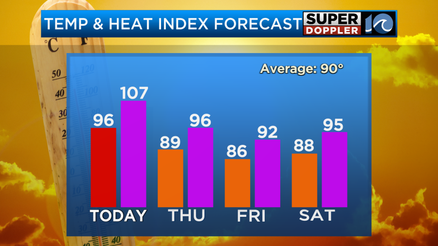
Along with that…The latest thinking is that the front will lift north a bit on Saturday. It won’t get too far north though. So high temps should stay in the upper 80s. We will have lots of clouds with more scattered showers and storms.

It should not be a washout. Sunday will have similar weather as the front stalls out.
We don’t need any more rain right now. However, over the next 48 hours some locations could pick up a couple of inches of rainfall.

A few storms could have some heavy rain today, but I’m more concerned about the clusters that form tomorrow afternoon. Check back for updates on that.
It’s all quiet in the tropics, and should be for at least a couple of days.
Meteorologist: Jeremy Wheeler


