Yesterday our high temperatures topped off in the low-mid 80s.

This was about 10-15 degrees above average. The calendar may say late October, but it is going to feel like late Summer for two more days. Today we are going to be just a little above yesterday’s highs. So temps will reach up into the mid 80s with a few mid-upper 80s inland.

We have high pressure just to our southeast with a strong cold front to our northwest.

The front is very slow moving. It will even stall out for a bit at times today. So we’ll have fair skies and light southwest winds here along with the local heat. Dew points are near 60. So there is also some light to moderate humidity.
With all of this said…I decided to throw in the beach forecast today during weather. Why not!

Water temps aren’t that cold. They are also running above average as they are in the mid-upper 60s right now. The surf will be be great for surfers. Waves will run about 2-3 feet with some 3-5 footers along the Outer Banks.

However, there is a moderate threat for rip currents. So be careful if you go for a swim. Also Stay hydrated. Especially if you go out to do some pumpkin picking, corn mazes, or trunk-or-treats today.
Tomorrow won’t be too much different. We’ll have some more clouds, and the breeze will be stronger. Winds will be out of the west/southwest at 10-15mph with gusts to 20mph. We’ll be partly cloudy. High temps will be in the low-mid 80s.

We won’t have any rain during the day, but there will be a few showers by the evening as the front edges into the region. The front will actually drop to our south Monday night. It will drop some more to the south during the day Tuesday. Then it will stall out for a bit. As that happens there will be a weak area of low pressure moving up along the front (offshore). This will push a lot of moisture up over the front and into the colder airmass. And I mean colder. High temps will only be in the mid 50s on Tuesday. Our model is even calling for low 50s.

The rain showers will be picking up through the day. It may even be briefly heavy.

Unfortunately, the rain showers may continue into the evening hours. This will likely impact trick-or-treaters if it pans out.

There’s a chance that the showers will drop to the south by the evening, but we’ll see. The models favor rain for now. Even the NAM model has rain in the evening. Rain is bad enough. However, the temps in the evening may be dropping from the low 50s into the upper 40s. Also, (yes there’s more). The wind will be strong. We could have some gusts to 30mph out of the north/northwest during the day. Gusts could still be up to 25mph in the evening. So check back tomorrow for updates. Hopefully, the forecast improves a bit. We’ll see.
Either way we’ll stay chilly for at least 3 days. High temps will be in the 50s Tuesday through Thursday of next week. Low temps will solidly be in the 40s, but we may also have some 30s on Wednesday and Thursday morning. Some frost may occur in areas that haven’t had a frost yet.
Tropical storm Tammy is responsible for some of the higher waves at our beaches lately. However, now it has gone back to post-tropical.

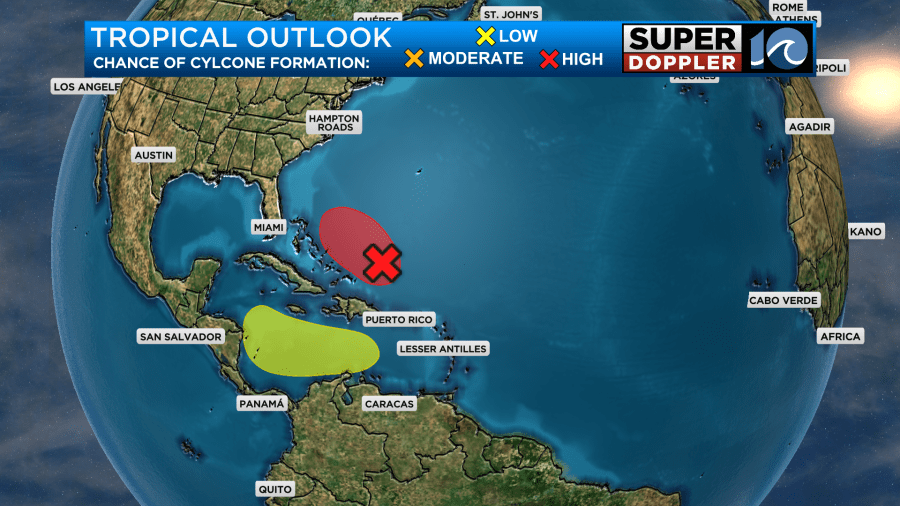
The feature is well east of Bermuda now. It will keep rolling east, and it will fall apart soon. There is another feature north/northeast of Puerto Rico that has a medium to high chance of formation as it moves north.

This is the same feature that I mentioned earlier that will become that offshore low. Even if it forms briefly, it will get wrapped up into that strong cold front. It will stay offshore, but it will be responsible for pushing the moisture into our area. Tropical systems can be finicky. So that’s why there may still be some wiggle room in the Halloween forecast. So check back for updates. There is another disturbance in the eastern Caribbean that has a low chance of formation as it moves generally to the west.
Meteorologist: Jeremy Wheeler


