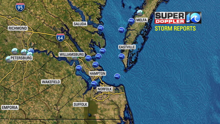
Last night we had some severe storms move through the region. There were a group of thunderstorms over central Virginia, and one of them got out ahead of the pack. This caused some damage between Petersburg and the Eastern Shore.
After that first set of storms, we had some more widespread and lighter rainfall.
Rain was heavy in a few places. However, some places didn’t get much at all. Here were some official rainfall reports:

I thought the Newport News report was wrong. However, Langley only had about 0.05″. My weather watcher, Barry in Gloucester, had a little under a half an inch.
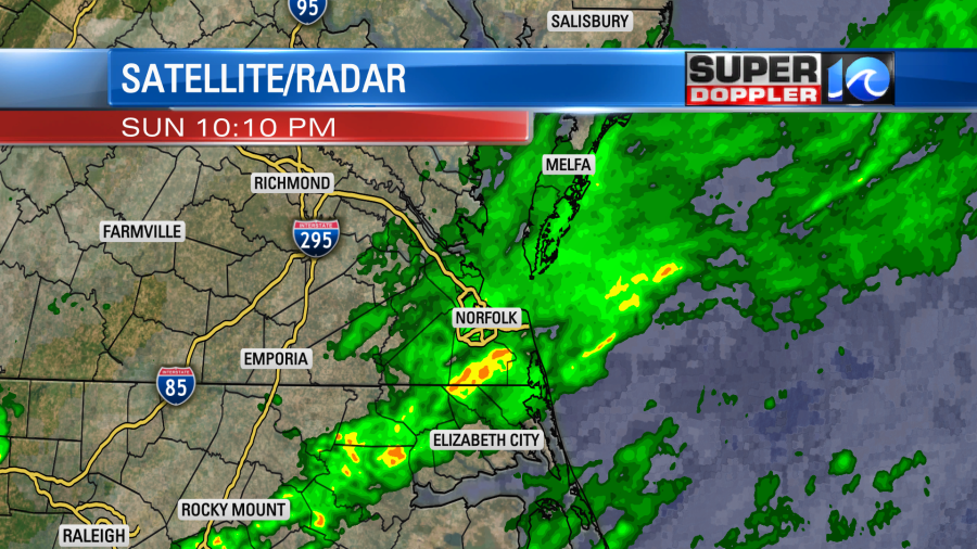
This morning the rain and storms had all moved offshore by the time we started the newscast. The front is now moving slowly through the region.
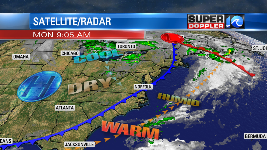
We’ll be a little cooler today, but it will still be warm for this time of year. High temps are aiming for the low-mid 80s.

We’ll have lots of sunshine with a steady/light west wind. Even though it will be warm we’ll dry out slowly through the day. Though in then next 12 hours it will actually be a steep drop.
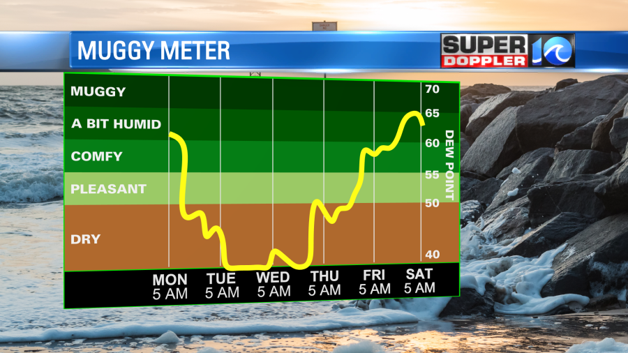
We’ll stay dry for the next 3-4 days. It should be nice with Fall weather returning. high temps will be in the upper 70s tomorrow. We’ll be near 70 Wednesday and Thursday. By late Friday we may see some rain from the remnants of Ian. It’s possible that we could get a good amount of rain next weekend, but this is not set yet. Let’s talk about it.
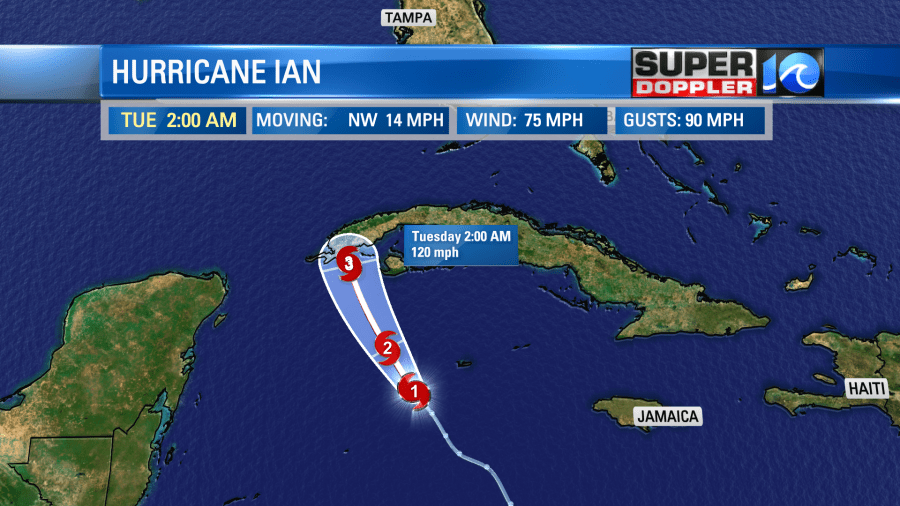
This morning the National Hurricane Center posted that Ian had strengthened into a hurricane. This was over the central Caribbean Sea. Tall storms had really started to fire up closer to the center. You can see it on the latest satellite (Purple areas).
The system is moving over some warm water. Sea Surface temps are in the 80s. Plus, there is not much wind shear. So Ian has a healthy outflow at the top of the storm. Remember, these are extreme areas of low pressure so the air wraps into the storm at the surface, then it rises around the storm. The air has to go somewhere. So it pushes out at the top. If this process gets disrupted, then it can weaken the storm. Moderate to strong wind shear can make that happen.
Anyway, Ian is forecast to strengthen to a major hurricane and cross western Cuba early tomorrow.
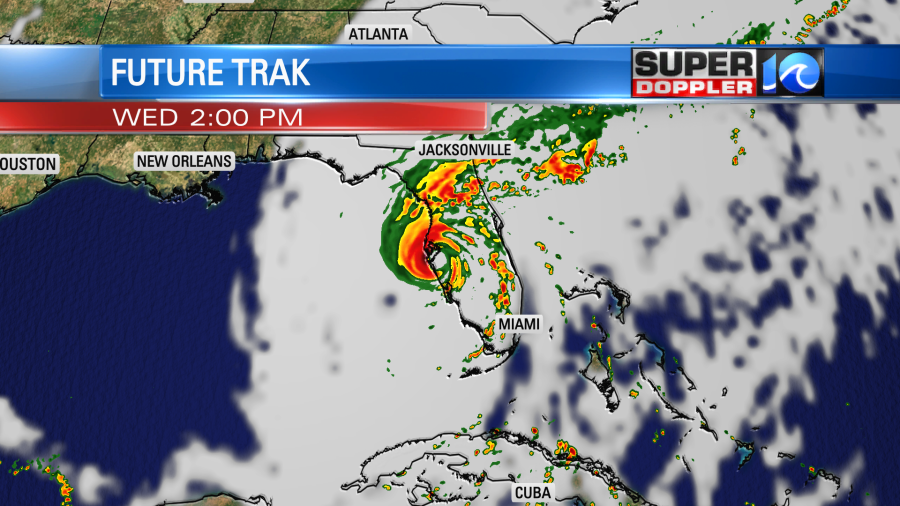
The hurricane could be briefly disrupted by crossing land, but this shouldn’t slow it down for long. It is then forecast to move north of the Gulf Of Mexico. It is expected to become a category 4 hurricane. After a couple of days it will make a turn to the north/northeast. It will then make landfall somewhere over Florida. Here’s the latest track:
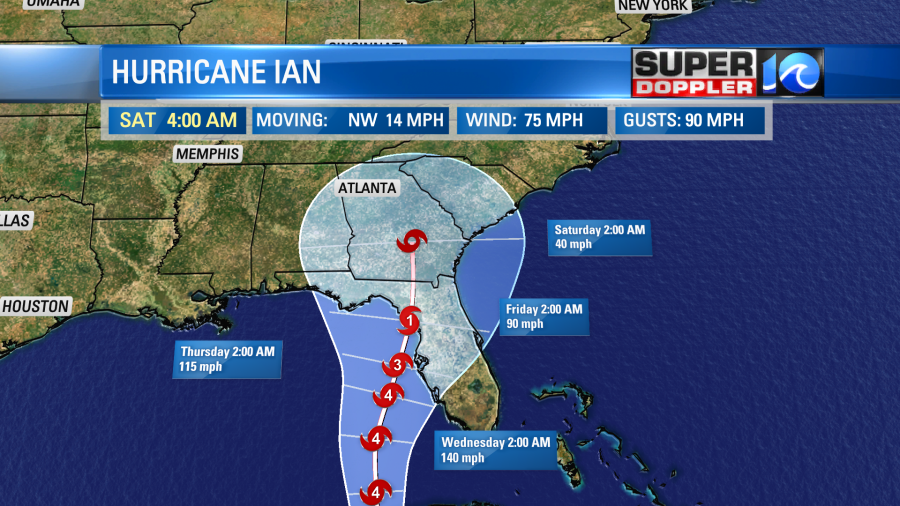
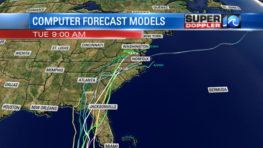
Now the tricky part here is the exact angle that Ian travels. It could hook a little to the east. If it does then it would hit land sooner and stronger (possibly near Ft Myers or Tampa. If it moves more towards the center line, then it would have more time to possibly weaken. If it moves even more to the west, then it could weaken even further before landfall. Here are several of the computer models.
Why is that? Well, as the storm system moves northward there is less deep ocean heat energy compared to its short-term track.
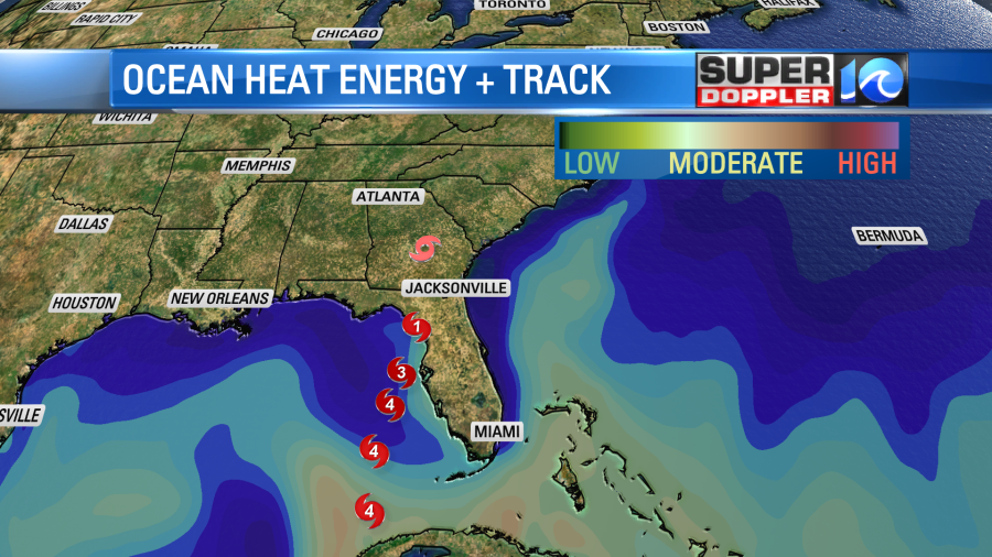
Also, the wind shear is forecast to increase over time. This will be due to a large upper level trough coming down over the U.S. and upper level winds increasing around it. The trough will be riding around a much cooler and drier air mass. A cold front is forecast to come down and wrap up into the system. This should help to cause some weakening. As Ian moves north over land it should also be cutoff from its warm ocean water supply. That is the main fuel for a hurricane. So the forecast calls for Ian to weaken.
Our Future Trak model has Ian on one of the more eastern tracks. So it has it making landfall near Ft. Myers and moving to the northeast. It would probably then heat northeast and stay offshore after that.
Meanwhile the latest GFS and European models are coming into better agreement on the forecast. They now both have Ian making landfall just a little bit north of Cedar Key.
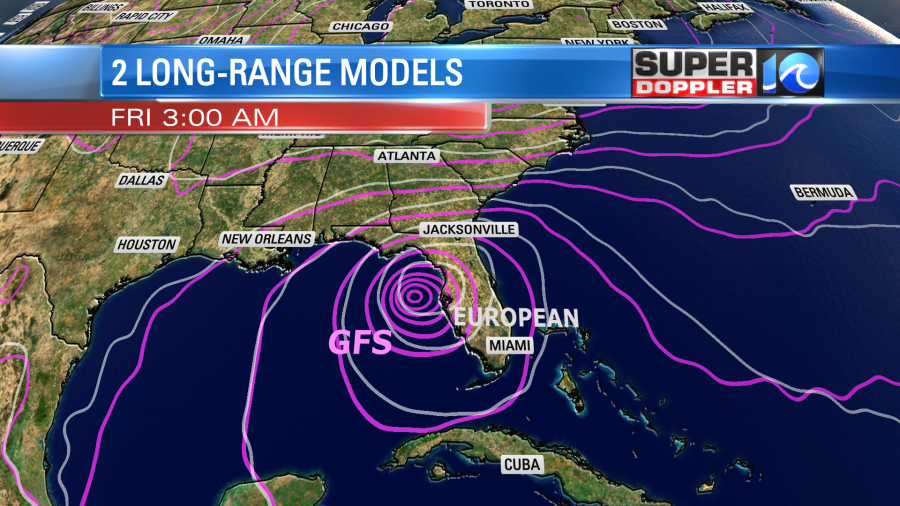
Then they have it moving north/northeast and weakening.

The GFS has it turning into a weak/broad area of low pressure that moves just to our south. It does bring us some rain (both do actually).
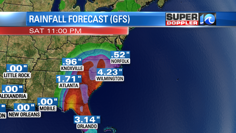
The earlier version of the GFS had about 1-2 inches. It has gone down since then. Keep in mind that our rainfall forecast can change dramatically depending on which path Ian follows. So I’ll have a little more confidence (hopefully) in that tomorrow.
Meteorologist: Jeremy Wheeler