There are no tropical systems near our region today, but there may be some tropical downpours from all of the humidity in the region. Let’s talk about it… Locally, we have a stationary front in the region along with a layer of deep/rich moisture.
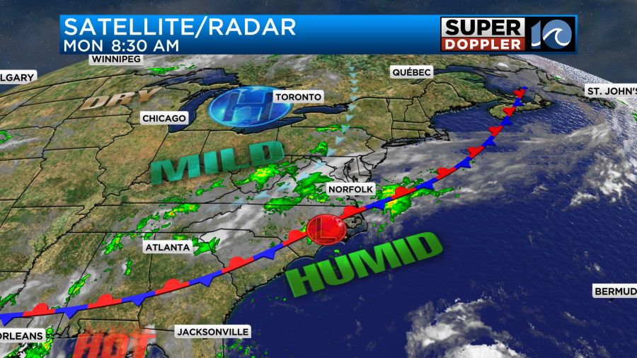
These features will bring us a chance for rain, thunderstorms, and some heavy downpours today. It’s possible that we could even have a few areas of flooding this afternoon. We’ll have a few showers at first, but the showers and storms will grow in coverage into the afternoon.

This will impact the kids returning from home from school. A large number of kids will head back to school today, but there are still a few districts that will head back early next week. Anyway, the rain should taper off as we go into the evening. Some areas could get 0.5″ to 1.5″ of rainfall before it wraps up. Maybe even 2″ in spots.
We’ll have an east/northeast breeze today at 10-15mph. We’ll also have a lot of clouds through the day. So high temps will only be in the low 80s, but it will be a muggy low 80s.
Tomorrow the front will drift a bit. Also a very weak area of low pressure should move out. So we’ll have some more sunshine tomorrow with lower rain chances. I think we’ll just have a few scattered showers and storms with a mix of sun and clouds. High temps will be in the mid-upper 80s, and we’ll continue with the high humidity. We’ll go back to mostly cloudy with scattered showers on Wednesday. A cool front in the Midwest will run down this way and merge with the current stationary front. It’s this combined front that will interact with (and possibly help guide) Idalia.
This morning tropical storm Idalia was strengthening over the northwestern Caribbean sea.
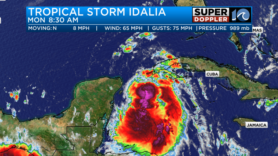
The system is sitting over very warm water, and it will move over some very deep/warm water in the near future. This means that the normal upwelling will not weaken the system, and it has ample fuel to strengthen. Also, wind shear should be low-to-moderate. Therefore the forecast for Idalia is rapid strengthening during the next 48 hours. The latest forecast from the National Hurricane Center has it as a category 3 before making landfall around the big bend of Florida. That will be some time around mid week. Tampa is on the edge of the possible path.
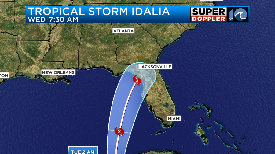
After that point it will move over land and weaken. It will bring hurricane forced winds into northeast Florida. Then it will bring tropical storm conditions to northern Florida and southern Georgia. It looks like the storm will then turn eastward and either track near the southeast coast or move offshore. This could put Idalia just to the south of our viewing area later this week.
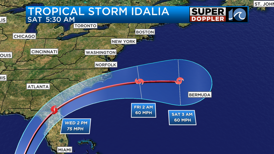
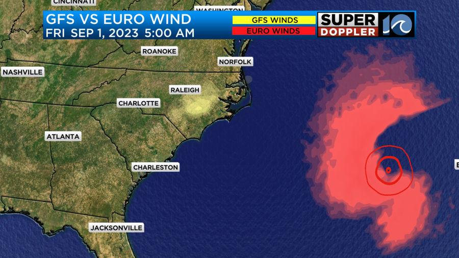
The models are in general agreement of the track with small deviations.
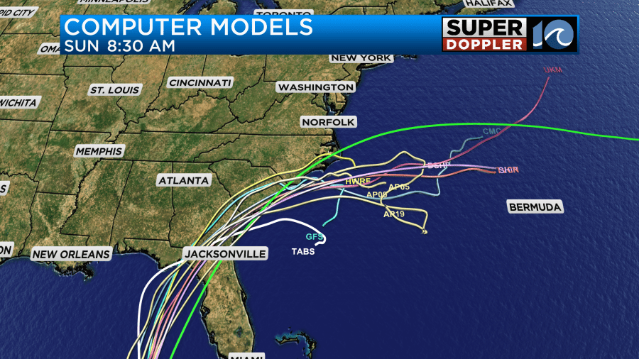
However, there are some big differences in the timing and rainfall.
For instance, the GFS Model is much slower than the European model. It has the center of the storm just to our south on Thursday. Then it meanders the storm just to our southeast Friday into Saturday.
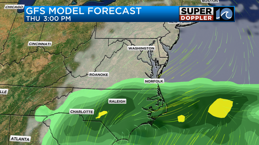

This would bring us a lot of rain, a long stretch of strong sustained winds, some tidal flooding, and some beach erosion.
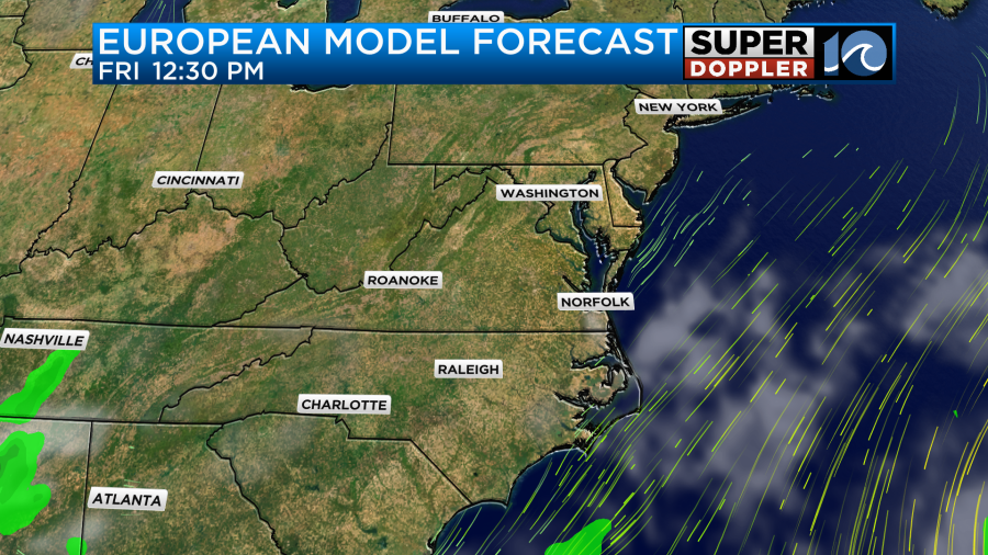
The European model on the other than is much faster. It barely has any rain up this way on Thursday and it has the system moving to our south/southeast. Then it zips Idalia fast out to sea on Friday leaving behind fair skies and light breezes.
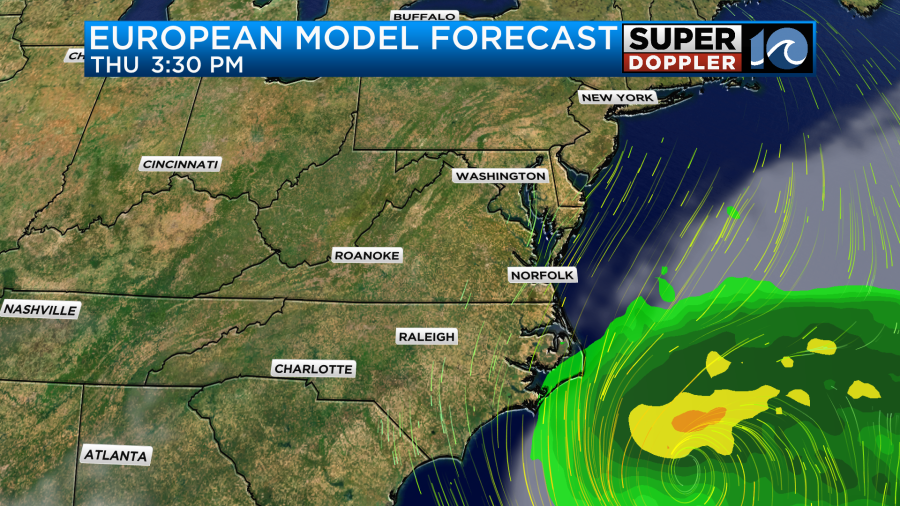
If the Euro pans out, then we would probably have little impacts in Hampton Roads.
The GFS model was upgraded over the last year or two. It may be handling the fronts better than the Euro. However, the Euro has a pretty good track record for mid-late forecasts.
So we’ll see which way they trend. They should come together after the system actually gets into the Gulf of Mexico and observations start to come in.
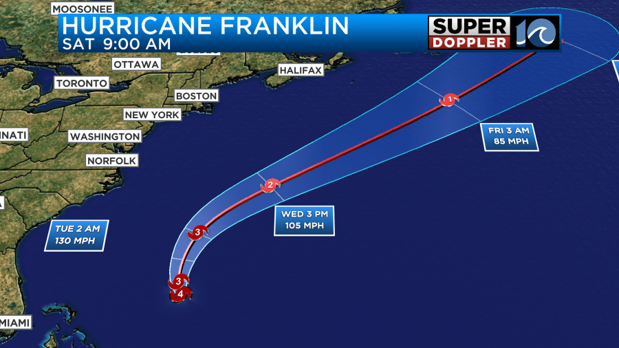
Meanwhile, hurricane Franklin has also strengthened. It is now a category 4 storm.
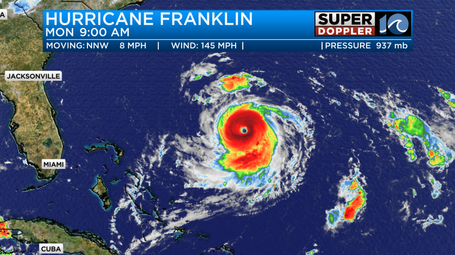
Luckily this one is out to sea, and it will likely stay out to sea. It is on a northerly track right now, and it is moving over warm water. It will turn northeast soon, and then move northwest of Bermuda. Then it will move into the north Atlantic.
While it will stay far enough away from Bermuda to spare them destructive winds, it will still bring them some big waves, rough, surf, and beach erosion. They could still get some rain and wind depending on the exact track. Franklin will bring us some high ocean swells and rough surf. We could also get some beach erosion here along our coasts. We will definitely have a high threat for rip currents for a few days.
We’ll have frequent updates on all of these systems.
Meteorologist: Jeremy Wheeler