Saturday morning update: Hurricane conditions and dangerous storm surge are expected in portions of the Bahamas through Saturday, and Hurricane Warnings are in effect. Hurricane conditions are expected along portions of the Florida east coast late Saturday and Saturday night, and a Hurricane Warning is in effect. The National Hurricane Center says dangerous storm surge is possible along parts of the Florida east coast.
The NHC says there is a risk of impacts from winds, heavy rainfall, and storm surge spreading along much of the the U.S. east coast through early next week, including the Hampton Roads region.
Get the latest local forecast at this link.
Friday night update: We’ve seen a few changes with Hurricane Isaias this evening as the 5 p.m. update came in from the National Hurricane Center. This storm is currently moving to the NW at 15 mph, and with it are wind speeds at 75 mph, and a storm expected to get a bit stronger in the next 24 hours.
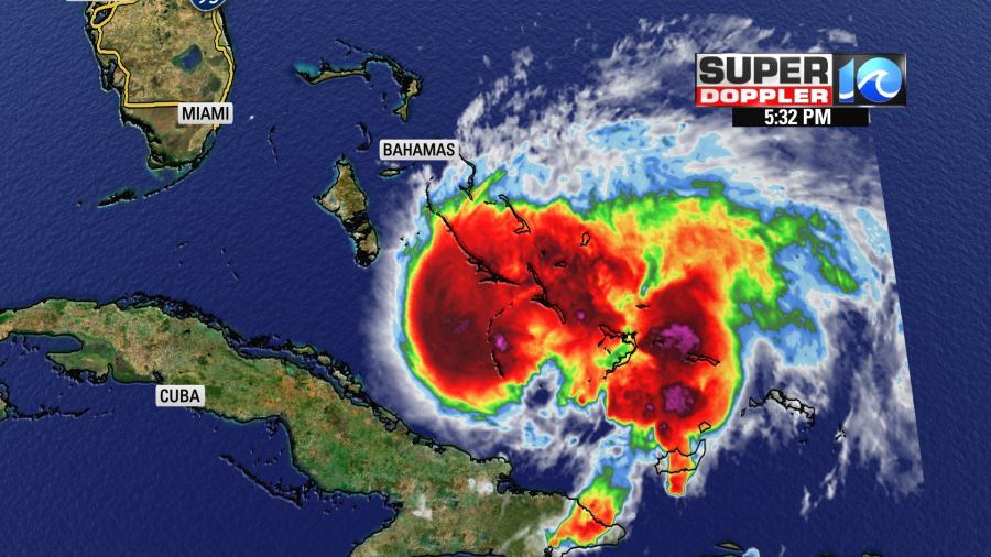
Infrared Enhanced Satellite
The areas of purple and dark red indicate where the thunderstorm activity is with this storm. Now lets talk about the forecast track:

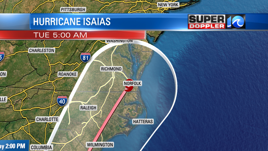
This storm is expected to quickly move across Hampton Roads Tuesday morning. Even though we see the Tropical Storm Icon right on top of us, no need to panic. A storm moving over land can be weaker, have less top wind speeds, and a decreased threat for tidal flooding.

These two tracks are examples. An inland track however, could mean an enhanced threat for tornadoes. Especially on the eastern side of the center of circulation. This area is where we see more spin in the atmosphere, which could lead to quick spin ups.
A track over the ocean would mean a stronger storm, higher winds and a bigger threat for tidal flooding. The storm will move through the area quickly, which should help us to see incredible amounts of rain, but with any tropical storm, heavy rain and flooding are always a possibility.
I would suggest getting a few extra items this weekend, also test out your generator if you have one, in case we see power outages Tuesday and lingering into the week.
Throughout this upcoming weekend, keep an eye on the official forecast. It will change as our two best weather models come into agreement. Casey Lehecka will be on air Saturday and Sunday morning from 6 AM – 8 AM. I’ll be on air in the evenings this weekend, 6, 10, and 11.
Look for extended video posts this weekend as well.
Meteorologist Jeff Edmondson


