Update Thursday Afternoon:
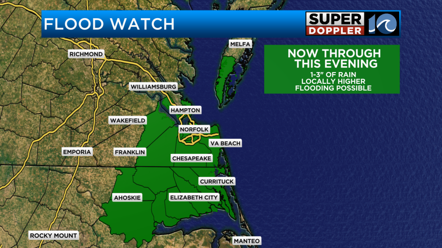
The Flash Flood Watch has been extended for the entire region through late Friday night, meaning the heavy rain makers will persist across the area not only through this evening, but into most of Friday as well.
Some locations across town have already picked up several inches of rainfall (which came down quite heavily), leading to flooding of low lying areas, some streets and drainage ditches. That’ll be the main focus to look out for on Friday as well, as another round of these scattered downpours is expected.
The stubborn stationary front across the region will pick up more moisture to our south and send it our way into Saturday… so these scattered downpours could persist into Saturday, too! An additional 3+ inches of rain is expected between now and Saturday afternoon.
Be careful around any flooding roads and areas in the next few days.
We’ll slowly dry out Sunday before the summer heat returns.
Stay safe and stay dry!
-Steve
______________________________________________________________________________________________________
I want to go back to June for a minute. I’ve been so busy with the heat and the tropics lately that I haven’t had a chance to talk about climate. June ended up being the 5th hottest on record.

It was definitely a hot month. It was 2.3 degrees above average. Meanwhile it ended up being pretty dry as well.
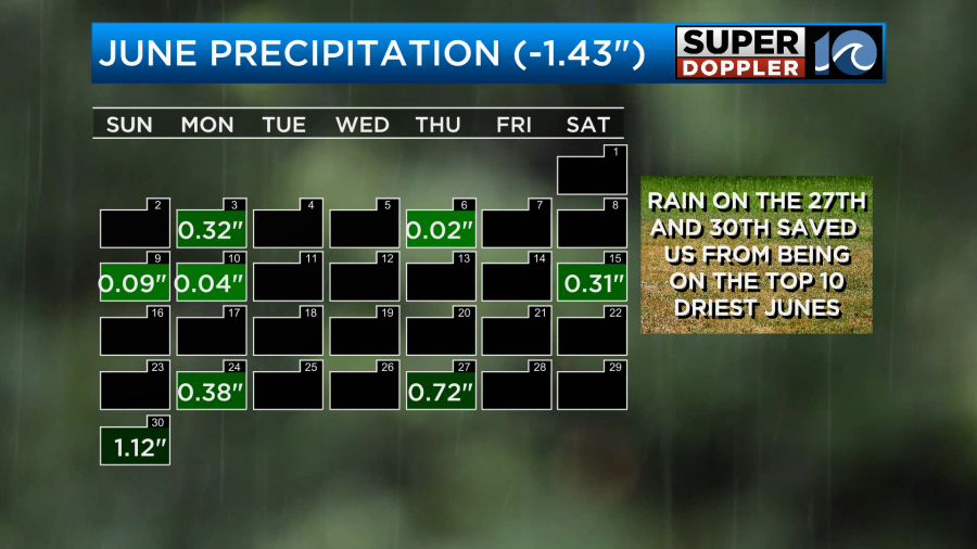
It could have been worse if it wasn’t for that rain at the end of the month. Now we are in July, and it is still hot and dry overall. High temps have been in the 90s for a while.
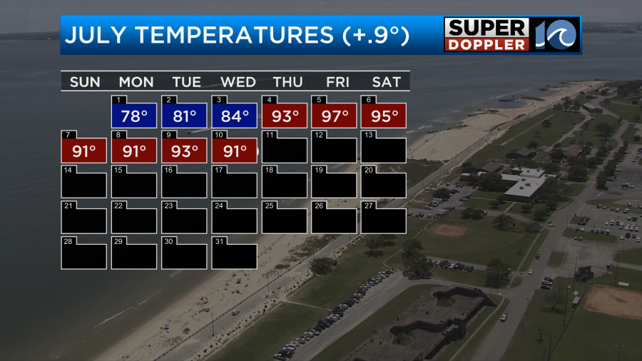
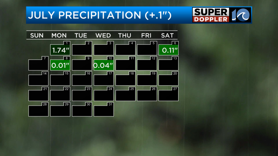
The thing is that the heat index has been near or over 100 for many days. We haven’t had much rain recently. I say that…Some locations have had much more than others. The data that I’m showing is for Norfolk which is our main climate site.
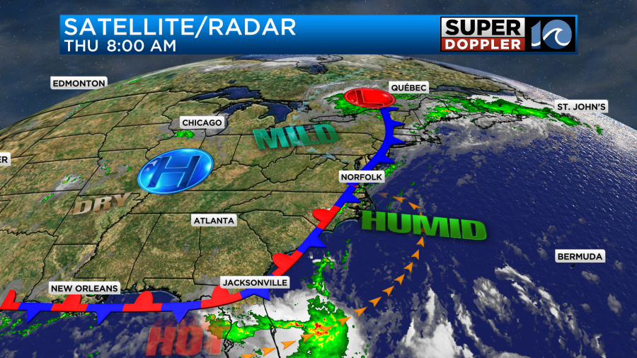
The good news is that we are going to get a break from the high heat today. A cool front is moving into the region, but it is stalling out on top of us.
Temperatures are going to cool down, but it will not be refreshing. High temps will be in the mid-upper 80s.
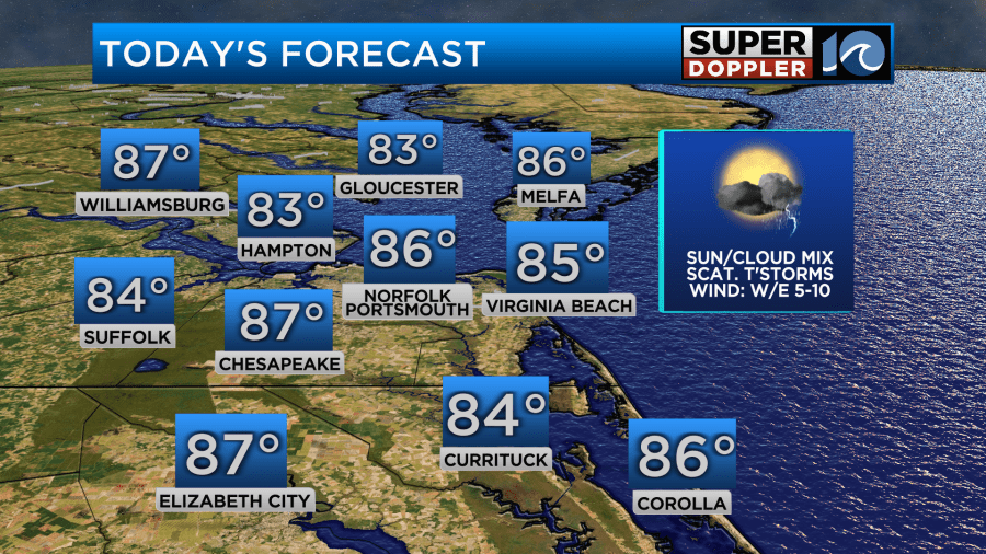
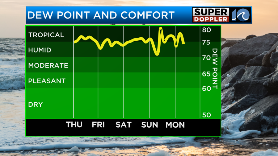
However, it will feel like it’s closer to 90 with the heat index. The dew points are above 70, and that is not going to change any time soon.
As the deep/rich moisture streams up along the east coast it will run into the stalled out front. This will create a lot of clouds, but it will also spawn a lot of scattered showers and thunderstorms. We’ve already had some spots of heavy rain this morning.
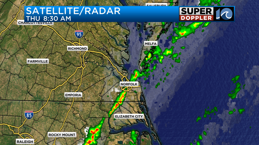
It won’t be a washout today, but there will be scattered showers and storms at times. Heavy rain will be possible.
The rain may be very heavy at times. This is why the National Weather Service put out a Flood Watch for the area. It goes through this evening.
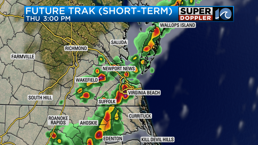
The front is forecast to wiggle back to the west a bit tonight into tomorrow. So the rain may back off through that time.

However, the front is expected to slide east during the afternoon. This will bring back more showers and storms to the region.

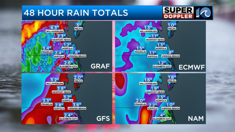
Heavy rain will be possible again. High temps will be in the upper 80s. We’ll have a mix of sun and clouds outside of the rainfall. Winds will be out of the south tomorrow at 5-15mph. The forecast rainfall through Friday afternoon will be a wide range. I’m thinking a half inch to 2 and a half inches with some locations getting 3 inches or more. Some locations could easily see 4 inches or more.
Again, it will stay humid tomorrow through the weekend. However, we do expect a little more sunshine on Saturday and Sunday. There will be some scattered showers and storms on Saturday, but I think there will be less time for them. Our model shows a big cluster during the late morning.

However, it pushes that rain out by the afternoon. Keep in mind the timing on that could easily change. High temps will be in the upper 80s to low 90s. We’ll have a few leftover showers Sunday morning. Then the rain should wrap up. We’ll have increasing sunshine, but that will heat the temps up to the low-mid 90s.
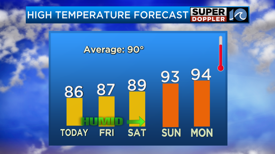
It looks like we’ll be back to more highs in the mid 90s early next week.
The tropics are quiet overall. There is one weak disturbance east of Florida that has a very low chance of formation.

This is drifting slowly west. It doesn’t have much room to form. We’ll monitor it over the next 24 hours.
Meteorologist: Jeremy Wheeler


