Update Monday Afternoon:
The Severe Thunderstorm Watch for the Virginia communities across Hampton Roads is in effect until 10pm. Damaging wind, hail and lightning are all possible this evening and tonight as a cluster of thunderstorms moves in from the north.
If you’re doubting the chance of thunderstorms tonight, I don’t blame you… because it’s been sunny all day and as we approach the late afternoon hours, there still isn’t a cloud out there!
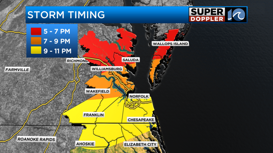
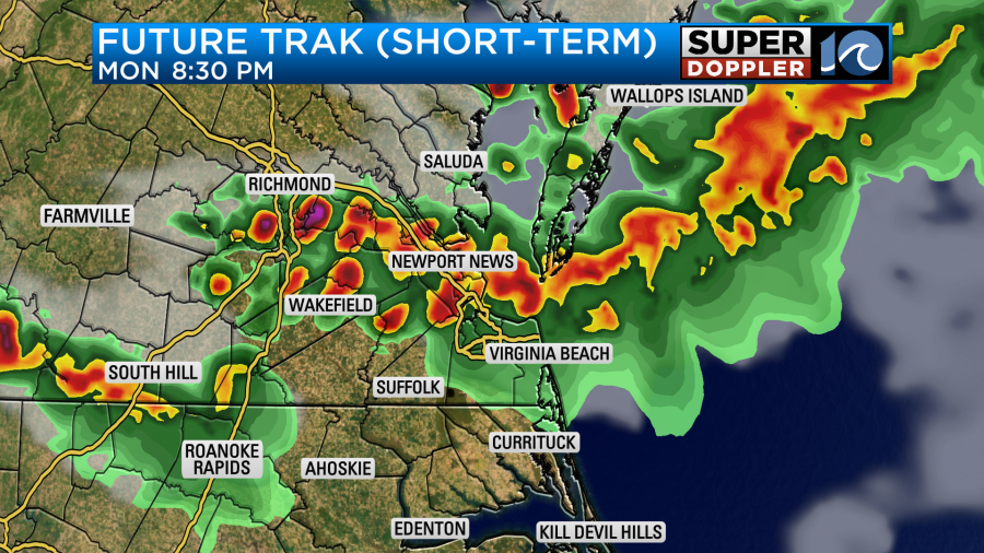
The cluster of thunderstorms will move in from the north this evening. Approaching the northern Neck and parts of the Eastern Shore between 5 – 7 pm, the Peninsula cities between 7 – 9 pm, and the southside between 9 – 11 pm.
Thunderstorms should weaken by the time they reach the state line, so NE NC folks may just get an overnight shower or two.
Oh… also, it’s warm. Really warm! We’ve potentially broke a record high of 89° set back in 1941 as most locations have crept up towards 90°! This warmth won’t last long though, the cool front dropping into the region tonight pulls in some cooler air. So tomorrow looks much cooler, highs may only be in the upper 60s for most!
Temperatures quickly rebound Wednesday back into the 70s as we sit back and try to enjoy this roller coaster ride of temperatures over the next five to seven days.
–Steve
______________________________________________________________________________________________________
We are coming off of a nice weekend. The weather was great both days with a good amount of sunshine, comfortable temps, and low humidity. Today we are actually going to have some pretty good weather for a while. However, by the evening some showers and storms are going to move into the region from the north. Let’s talk about it.
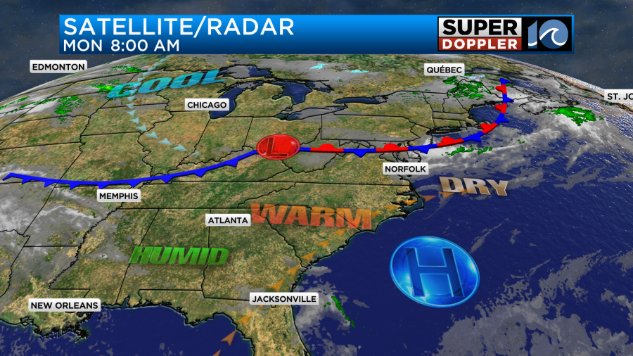
Today we have a stationary front to our north with an area of high pressure just to our southeast.
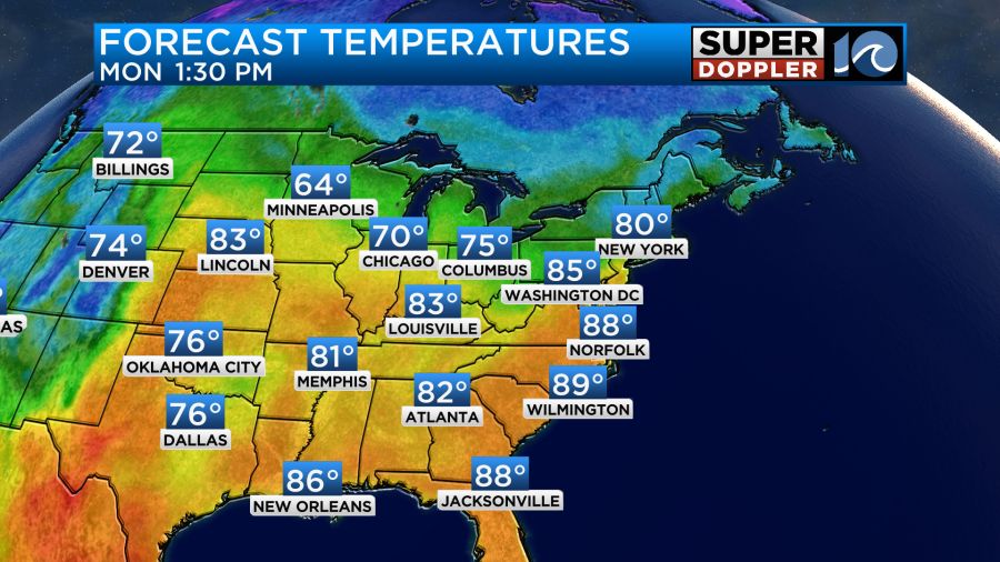
We’ll have lots of sunshine for a while today. The stationary front will remain to our north. In fact we’ll have a warm southwest breeze running at 8-12mph during the entire day. This will setup will push our high temps up to the mid-upper 80s this afternoon.
It will be a little cooler near the shore and on the Eastern Shore. So the weather looks great for a while. However, the low pressure system will slide east along the front today. This will pull the front down behind it, and that will move into our area by this evening. As the front sinks south there will be some scattered showers and thunderstorms. The models handle the timing and coverage differently. The High Resolution Rapid Refresh model (HRRR) has storms kicking off by the early evening in the area.

It even has a few by the late afternoon north of the metro. So basically, it is earlier and has more coverage than most of the other models.
In contrast our model has pretty much nothing during the day. It does have some storms dropping south during the evening with most of the activity in the late evening and overnight hours.


The hi-res Nam model has the least rain, and it also favors the later hours. Keep in mind that the HRRR model almost always tends to overdo storms in our region.
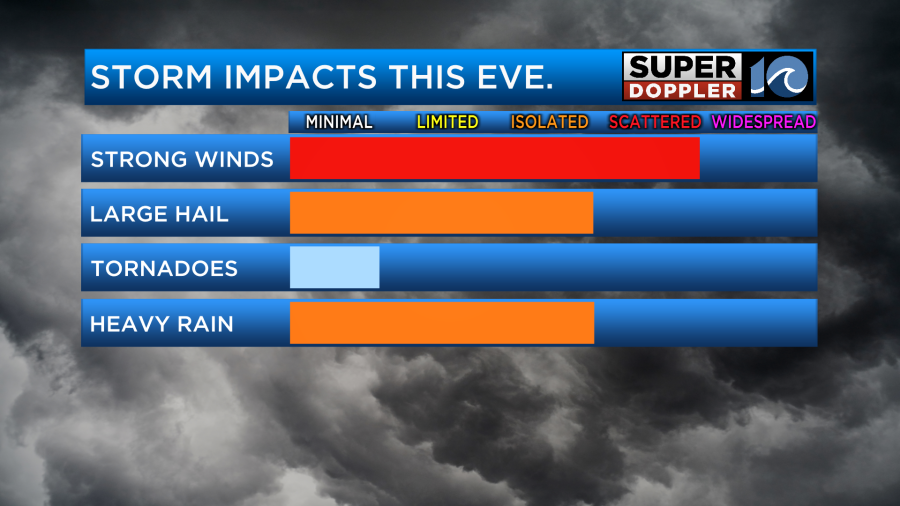
There is a slight risk for severe weather this evening. Dew points will rise to near 60 by that time, but it will still be dry for most of the day. There will be some instability tonight, but I don’t think there will be a lot of wind shear. This basically means that there will be some isolated to scattered strong storms this evening, but the coverage (amount of storms on the map) is questionable. Regardless, the whole region is pretty much in that slight risk.

I’ll say it… I think the risk is overdone on the south end. We’ll see. Either way the main threats will be strong gusty winds and large hail. There may be some isolated downpours. The threat for tornadoes is minimal.
The storms will sink south as the front does. Unfortunately, the rain may fall apart before reaching North Carolina. It could barely make it to the southside depending on which model you favor. However, the front will sink just to our south tomorrow. So tomorrow the temps will be much cooler across the whole region. High temps will be near 70 in the metro.

There will probably be a split in temps. It will be near 70 in the metro, in the upper 60s near the shore and on the Eastern Shore, and it may hit the mid-upper 70s inland/south.
We’ll have a mix of sun and clouds. There may be a stray shower, but the chance is very low. The front will lift back north as a warm front on Wednesday. So temps will warm back up to the upper 70s. We’ll be partly cloudy with some isolated showers. Then we’ll be partly cloudy with a few showers on Thursday. High temps will be in the low 80s.
temp trend.
I’ll talk about next weekend’s weather in tomorrow’s weather blog.
Meteorologist: Jeremy Wheeler