Last night hurricane Dorian restrengthened a little bit. This was no surprise as there was little wind shear, and it was moving over open/warm water. So the eye started to sharpen up a little on radar. Plus, there were some decent heavy rain showers wrapping into the western side of the storm.
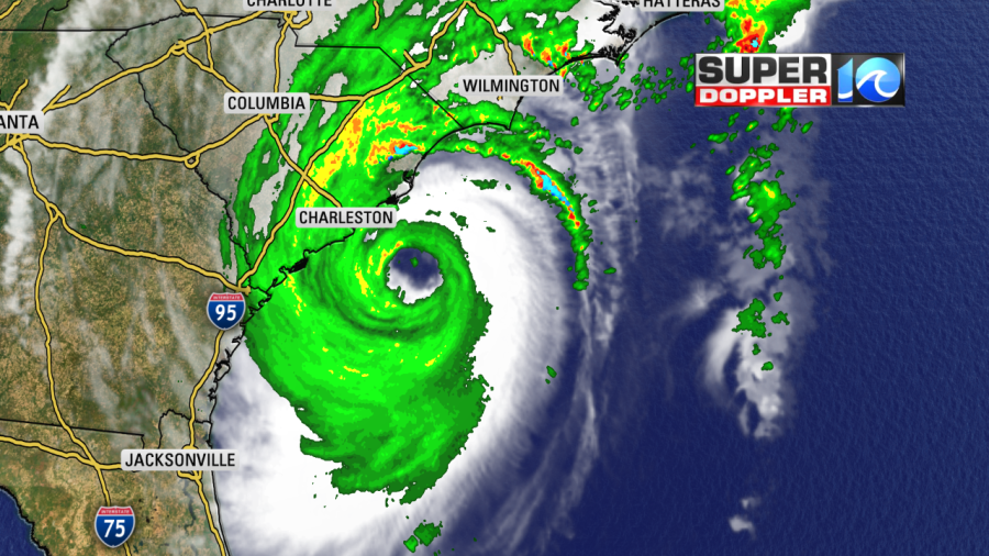
Hurricane force winds were reaching the shore this morning, and the storm was edging north/northeast.

The sustained winds this morning were back up to 115 mph. Dorian is forecast to start moving northeast pretty soon. Dorian could briefly make landfall east of Charleston. It may also go over land near Wilmington, North Carolina. These land interactions could potentially weaken the storm, but we can’t count on that
The forecast has been fairly consistent in keeping Dorian a Category 2 hurricane as it moves near or over Hatteras Friday morning.
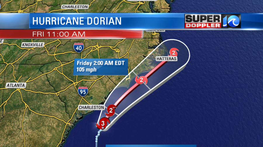
The storm is then forecast to pick up it’s forward speed as it moves away from land.
The models are in pretty good agreement on the track up to this point. They have been pretty clustered around Hatteras for the last 36 hours. They continue to show that track again today.
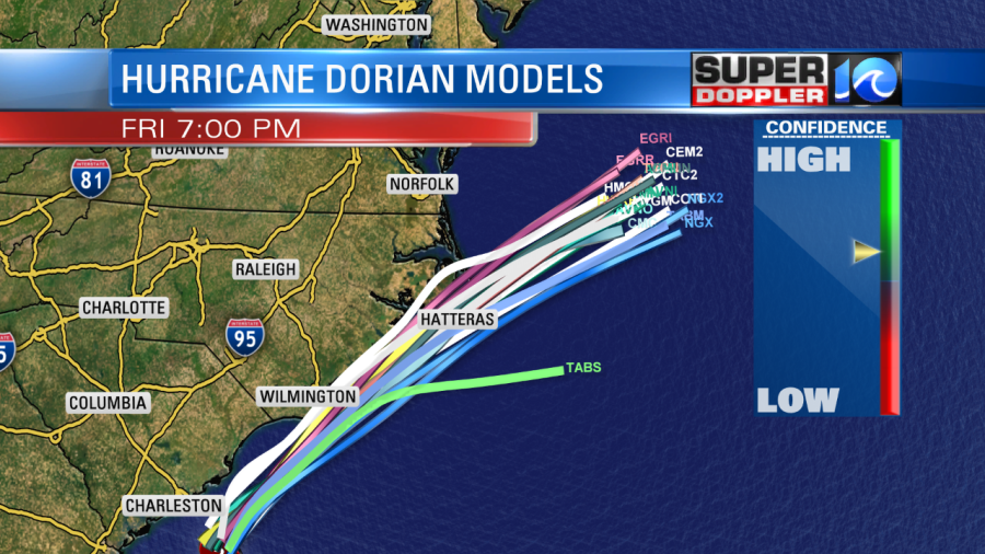
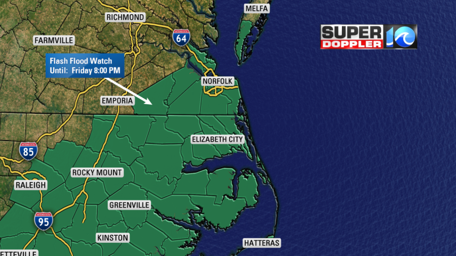
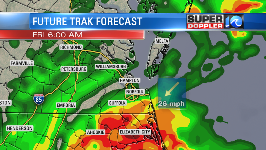
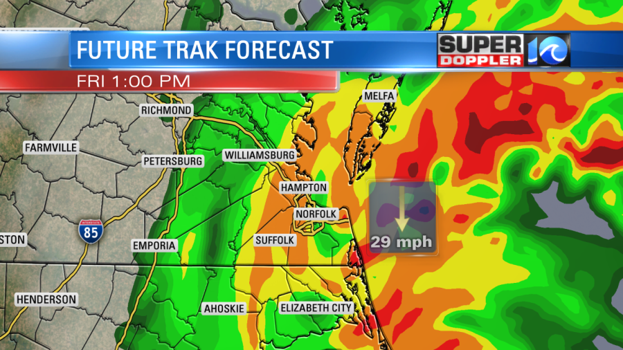
There is still some wiggle room, though. It could pass a little north or south of Hatteras. Regardless, this system will interact with a cold front. That will allow the storm to expand. The heavy rain and strong winds will easily be able to push up into Hampton Roads. The rain could cause flooding over a large area. There is a Flash Flood Watch out for most of the viewing area until 8 p.m. Friday.
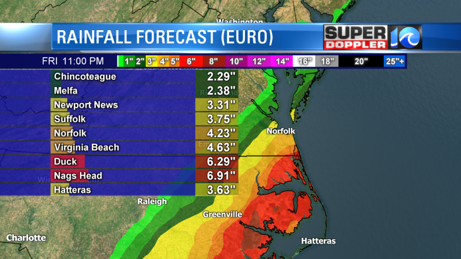
The models are showing a band of heavy rain that will align from southwest to northeast. Here is the European model’s estimates:
However, our Future Trak model has higher amounts into southeast Virginia:
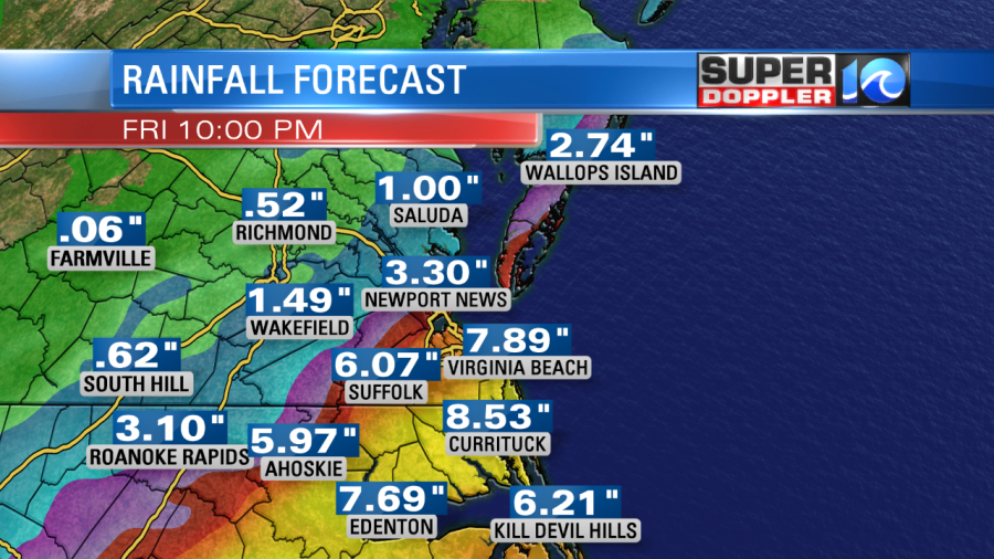
I’m in agreement with these numbers. I think we could see 6-10″ from Virginia Beach/Chesapeake south to the Outer Banks and inland North Carolina. I’m calling for 4-6″ for the rest of Hampton Roads with lesser amounts 3-5″ for both Peninsulas and the Eastern Shore. It may be more like 2-4″ towards the Middle Peninsula.
Remember, this rain could cause some flooding and street flooding alone. However, later in the day there will also be some (tidal) flooding. The rain could have a tough time draining during high tide. High tide is during the afternoon between 2 p.m. and 5 p.m. Here is the latest tide forecast for Sewell’s Point. Major tidal flooding is now in the forecast.
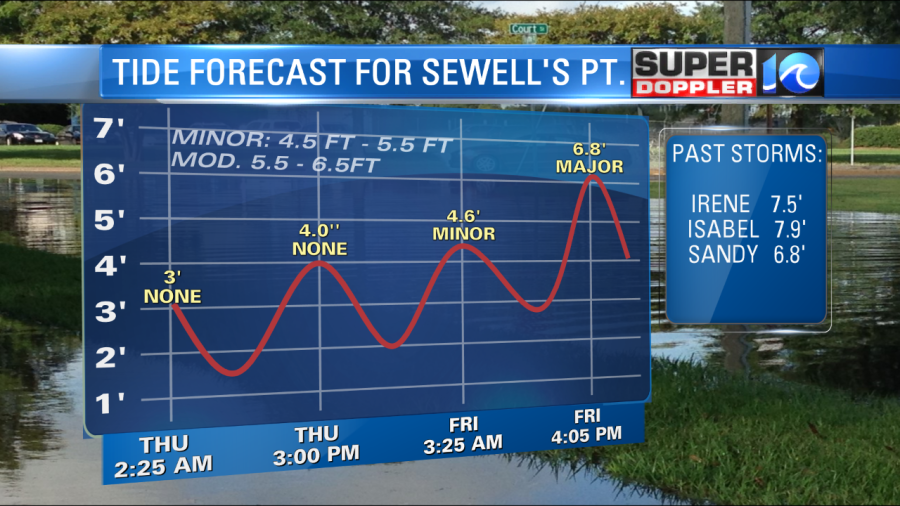
This level is comparable to hurricane Sandy (2012). Remember though…during Sandy the storm was far offshore, and we didn’t get much rain. The levels will also be major across the Outer Banks:
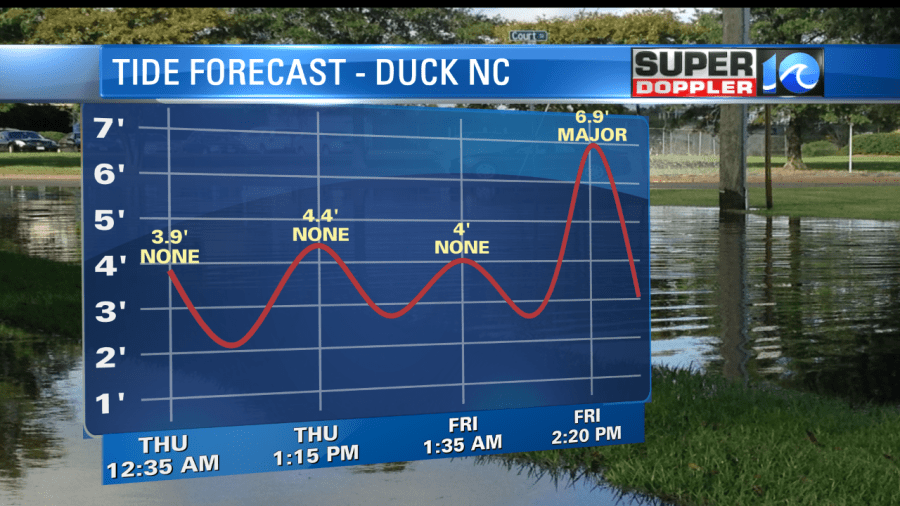
There will likely be some Sound-side flooding as we go into later Friday. This will be as the winds turn to out of the northwest. Here is a link to the updated tidal forecast from the National Weather Service for (all) areas: NWS Water Level Forecasts. Please check it for updates.
As far as the timing of the rain…today won’t be too bad. There will be some outer rain bands coming up from the south. A couple of these bands could have rotation. So an isolated tornado is not out of the question.
In fact, we could see isolated tornadoes form anytime from later today until Dorian moves away from land later Friday. Otherwise, we won’t see too much activity today. A couple of rain bands will come up from the south, but they will be scattered. This will be the case all the way into the late afternoon and evening. By tonight the bigger area of rain will move into the region. This will be after midnight. Then rain will become widespread into tomorrow morning.
The rain will be heavy and over most of the area from the mid-morning into the late afternoon.
The rain should edge out by the evening.
Wind will be severe over the Outer Banks, parts of northeast North Carolina, and near the shore in Virginia. Again, the wind won’t be bad today. Easterly at 5-15 mph.
By tonight, however, the winds will increase 20-30 mph with gusts to 55 mph. Expect higher gusts near the shore. By Friday morning, Dorian will be approaching Hatteras. The winds will quickly increase between 4 a.m. and 11 a.m.
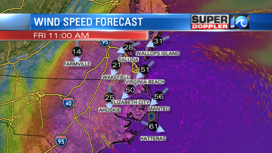
The winds along the Outer Banks could reach 50-65mph with gusts up to 90 mph. There may be some gusts up to over 100 mph over the southern Outer Banks. Remember that is where the center of the storm is forecast to pass.
The wind inland over North Carolina will run at about 30-50 mph with gusts to 65 mph and lesser winds farther west. Over the Southside the winds could run at 20-30mph with gusts to 60mph near the shore. Gusts will be closer to 40-50 mph inland. Over the Peninsula and Middle Peninsula, winds could reach 15-25mph with gusts up to 45mph.
I’ve got 20-30 mph winds on the Eastern Shore with wind gusts possibly reaching 55mph. That will be more likely as the storm moves away Friday afternoon.
All of these details are still subject to change. Especially if the track changes. It’s possible that Dorian could weaken if it moves over land closer to Charleston or Wilmington. However, it’s also possible that it could track a little more north. This would bring it closer to the Oregon Inlet, and it would allow even stronger wind, rain and tides to move up to southeast Virginia.
I’ve seen a lot of hurricanes weaken before they move up into our region — especially when they come from the southwest. However, Hurricane Matthew (2016) did expand as it encountered a cold front. It was actually over 100 miles southeast of Hatteras. However, we had a ton of rainfall before that hurricane passed by. So that is different this time.
Lately, we have dried out quite a bit and we don’t expect as much rain this time. Hurricane Arthur didn’t cause too much damage for moving right over the Outer Banks. However, Dorian’s wind field is bigger.
So do your final preparations today. Stow away lawn furniture, and secure garbage cans. Get fuel for the generators because there will likely be some power outages. Especially over the Outer Banks and closer to the storm’s center. However, don’t underestimate the winds in Hampton Roads because we are under a tropical storm warning. Remember tropical storm force winds are between 39 and 73 mph.
There will be tidal flooding and general flooding from the rain. So be prepared for possible flooding in your area. Street flooding could be bad enough that you may not be able to get through some streets and roads. Again this is mostly for Friday.
Stay tuned for updates to all of this. We’ll have them throughout the day.
Meteorologist: Jeremy Wheeler