Beggars can’t be choosers. That’s the age-old saying. It pertains to our recent weather. We were so dry for so long that we begged for some rain. Well … we got it. We had the heavy rain and damaging winds last week. Now we have this pesky area of low pressure offshore. While, I’m happy to get some more rain, the trade-off is that the weather outside today will be downright crummy! This is what is looked like at Lynnhaven Inlet in Virginia Beach this morning.
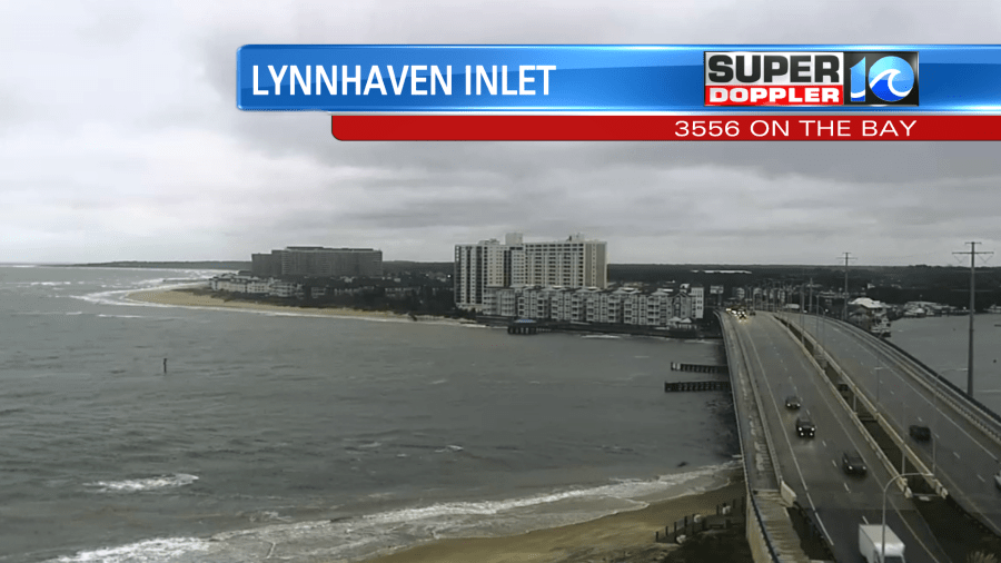
Temps were in the 40s and 50s, and there was a strong breeze out of the northwest. There was drizzle … a few showers. It was rough at the bus stops. Today won’t get much better. We’ll stay cloudy all day with drizzle at times and a few rain showers.
The wind will stay up out of the northwest at 10-15mph with gusts to 25mph. This will keep high temps in the 50s.
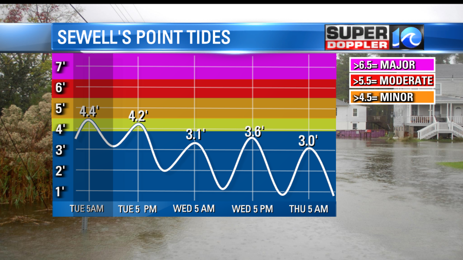
The tidal flooding wasn’t bad this morning. It was minor. The tide levels over the last 36 hours have been coming in dramatically lower than forecast. I talked about how weird and tricky that forecast was in yesterday’s weather blog.
The low pressure system did move offfshore, but it stayed just a little more to the west than expected. Also, it stayed a bit weaker.

This also shifted the wind direction slightly (out of the north/northwest instead of due north). Also the strongest winds were over a smaller area near the shore. The moon phase was already not favorable for a naturally high tide (waxing gibbous). So the tide actually came in about 2 FEET below forecast yesterday. This morning we hit between 4.3 and 4.4ft. This was also below the forecast. Going forward we’ll only have some nuisance to minor tidal flooding this afternoon.
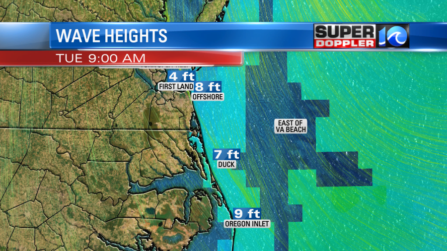
Even though the tide forecast for the Outer Banks will be minor. There will be some more ocean overwash down there. This is due more to the very high waves that are running down that way. They have been running about 7-10 feet near the shore.
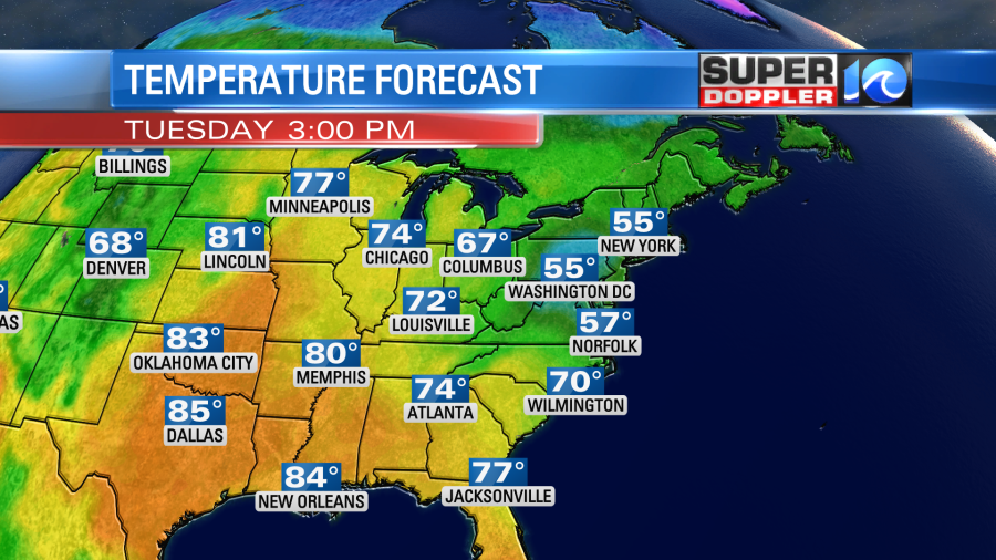
Tomorrow the low will slowly work its way eastward and farther offshore. So we’ll likely have some more drizzle in the morning with cloudy skies. However, the precip should move offshore during the afternoon. If we’re lucky, then we may have a little clearing during the late afternoon, but we’ll see. High temps will be a little better. They will be in the low 60s. By Thursday we’ll have some nice weather back in the region as high pressure slides east. We’ll be partly cloudy with high temps in the low 70s. That’s it. No strings attached. We’ll warm up to near 80 on Friday with partly cloudy skies. A cool front will swipe through the area Friday night into Saturday. That will cool us down next weekend.
There are 2 tropical disturbances in the Atlantic Basin.
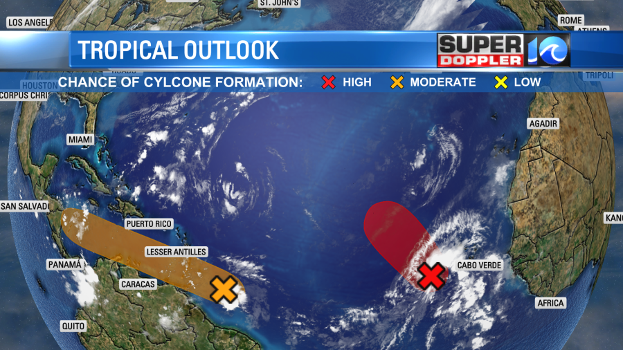
The one in the eastern Atlantic will likely stay out to sea, but it has a high chance of formation. The one closer to the middle of the Atlantic has a medium chance of formation, but it is on a track to the west/northwest. It should stay well south of the U.S. (Should).
Meanwhile on the west coast of Mexico there was a recent landfalling hurricane. Hurricane Orlene was a category 4 at one point ,but it wasn’t that strong at landfall. It did make the headlines, but it was dwarfed by the east coast weather. Here is an article with more details. Hurricane Orlene.
Meteorologist: Jeremy Wheeler


