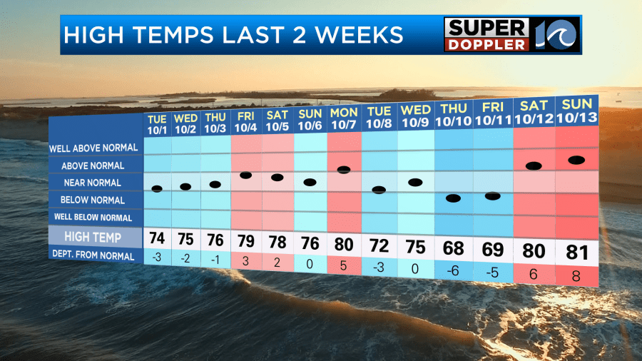
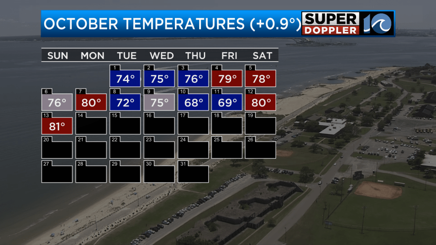
Over the weekend we had some nice, mild, and dry air in place. It was comfortable, but we did hit 80 degrees or higher both days.

However, on Saturday Norfolk was one of the only 80 degree readings in the region. So that may have been a bit misleading. For the month so far we are running about a degree above average.

We are running well behind on precip.
Despite a cold front moving into the region we are not going to get any help with rainfall. However, we will get a big cool down.
As I write this, the cold front was still to our northwest, and we had a southwest breeze.
The cold front will move through the region today. Temps are going to warm up to the mid 70s by around midday. Then they will fall to the upper 60s late in the day.
Winds will turn out of the northwest. They will gust up to 25mph this afternoon.
We won’t have any rain along the front. We’ll be partly cloudy with some more clearing possible late in the day. I’m hoping we stay pretty clear this evening. That way we can possibly go out and see the comet again. The comet will be visible in the western sky about 45 minutes after sunset.
Don’t be fooled by Venus. It will be a bright star just above the horizon. The comet will be to the right of Venus.
Anyway, tomorrow we will be much cooler behind the front. High temps will only rise to the low-mid 60s.
We’ll be partly cloudy for a while. However, during the afternoon an upper level low will be rolling in overhead. This is going to increase the cloud cover. There will probably be some isolated showers and sprinkles, but it will be too dry for anything more than that.
The upper level low will sit over us late Tuesday into Wednesday. This will keep the clouds up a bit, and it will allow for a couple more light showers or sprinkles. No matter what, this won’t add up in the rain gauge. At least not more than a few one hundredths of an inch.
Temps are going to start in the 40s Wednesday morning. They will only top off near 60 in the afternoon. That’s about 10-15 degrees below average. It will be time to pull out the warmer gear for sure. The coldest temperatures may happen on Thursday morning. Lows will definitely be in the 40s, but there will probably be some 30s inland. It’s even possible that there will be some mid 30s far inland and north. That may allow for some patchy frost to form. We’ll update you on that over the next couple of days.
Either way high temps will be in the 60s through Saturday.
It will be very dry through that time as well.
Hopefully, some of these big cold fronts will be able to impact the tropics. We need the water to cool down. Luckily, there are not any tropical systems in the Atlantic right now as Leslie has fallen apart. However, there is a weak tropical disturbance that we are tracking in the eastern Atlantic.
It is moving generally to the west. It has a medium chance of formation over the next few days. It could impact the Lesser Antilles as a tropical depression or storm. We’ll keep an eye on it, and bring you the latest.
In world news… There has been a lot of flooding this year over different parts of the world. I even talked about how the wacky weather patterns have caused greening over sections of the Sahara Desert. Well, there are also some areas with with severe drought. One surprising article that I found today talked about how drought over parts of the Amazon river basin are really disrupting lives and businesses. Here is the article. Drought over Amazon basin.
Meteorologist: Jeremy Wheeler