Here we go. When I walked in to work this morning the models were flipping around so much it looked like a chef making flapjacks. Our Future Trak model had trended up to about a foot of snow while most other models had decreased since yesterday. I think the GFS model was down to 1-3″. Since then they have trended a little closer together, but this thing is far from set (as of this morning).
High pressure is moving out to sea. A strong cold front is approaching from the northwest.
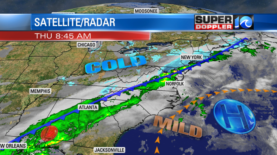
Temps started off mild this morning. After hitting the upper 50s yesterday we only bottomed out in the 40s. It was even near 50 in a few spots. So we’ll warm up today to near 50 during the late morning. Then the cold front will move through around midday, and that will start dropping the temps. Winds will increase out of the north.

We’ll have a lot of cold rain this afternoon for the region with a wintry mix to the north.
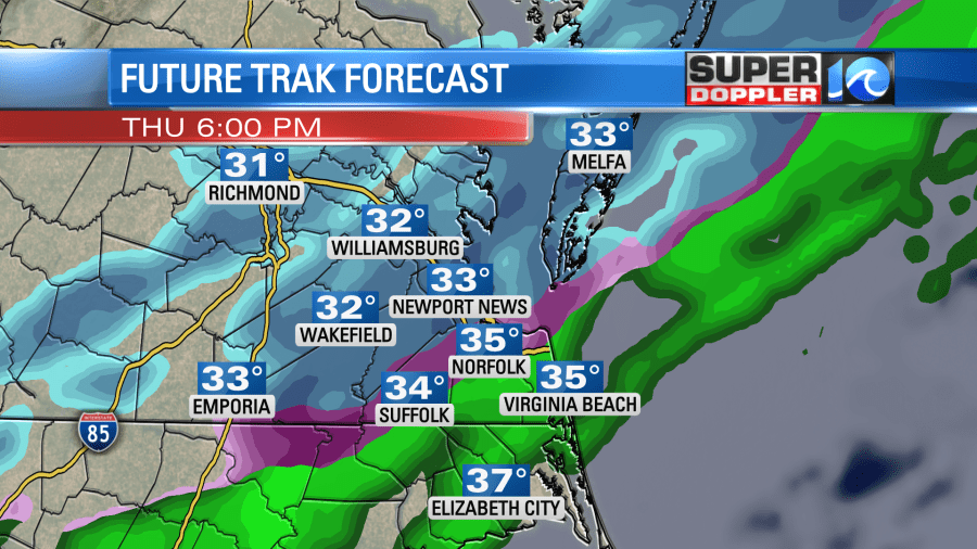
Temperatures will keep falling into the evening. The wintry mix will keep sinking southward.
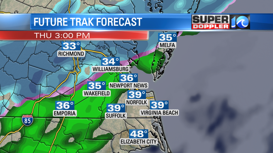
It might stick for a bit north of the metro through that time. There could be a light accumulation on the grass and decks. However, it should melt over the metro through the evening. Remember the ground will be wet, ground temps are above freezing, and surface temps will be above freezing. However, any precip falling during an evening commute can cause problems. In this case roads will at least be wet and could easily be slick from some slushiness. The precip could briefly end as some light snow, but again…a good bit of that should melt. Overnight, we should dry out. The models have trended with a drier scenario Friday morning. The GFS does have some very light precip from Virginia Beach south. Ours does as well.
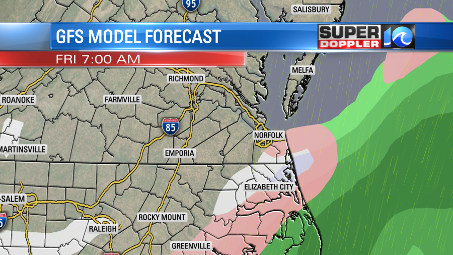
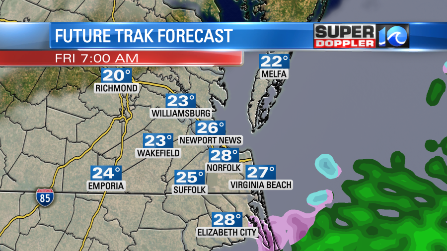
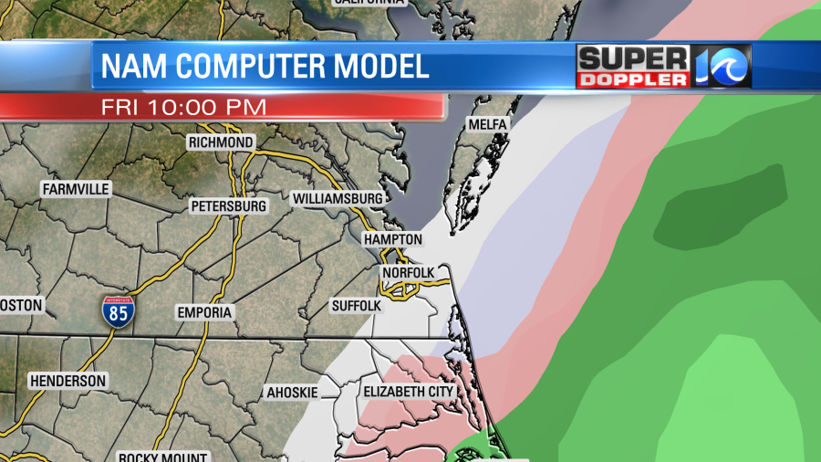
The NAM model does have some light precip in the morning, and it is a tad more north than the GFS. Possibly with some iciness over northeast North Carolina.
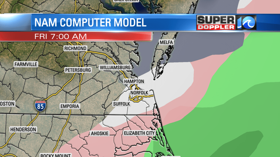
Some other models show this freezing rain and/or sleet as well. Our model has the highest resolution. So it probably is more accurate in this case. At least in terms of coverage, but not necessarily in the placement.
The cold front will stall out to our southeast tomorrow with a weak area of low pressure riding northeast (but offshore) along the boundary. The models have handled this feature differently over the last couple of days, and this continues to a degree this morning.
They are in pretty good agreement at bringing back the precip through the day on Friday. They slowly lift the precip up from the south as snow. They show a mix over the Outer Banks.
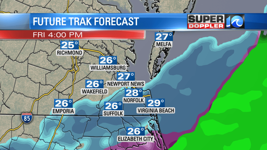
The GFS has trended a little later, but it does have the same trend generally.
Almost all of the models have the most amount of snow during Friday evening. Most of them have the snow reaching as far north as the Northern Neck.
The NAM and hi-res NAM, however, have trended much farther to the south.
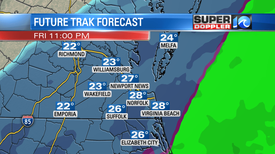
The models have the precip winding down into early Saturday morning. Then they tend to dry things out by midday.
As mentioned at the beginning of the blog, the models vary quite a bit for amounts. We have to keep in mind that some of them are including the melting mix tonight. It might not all melt, but amounts should be very light. Tomorrow into tomorrow night is when the accumulations will start to stack up. Here are 4 of the models’ snowfall forecasts:
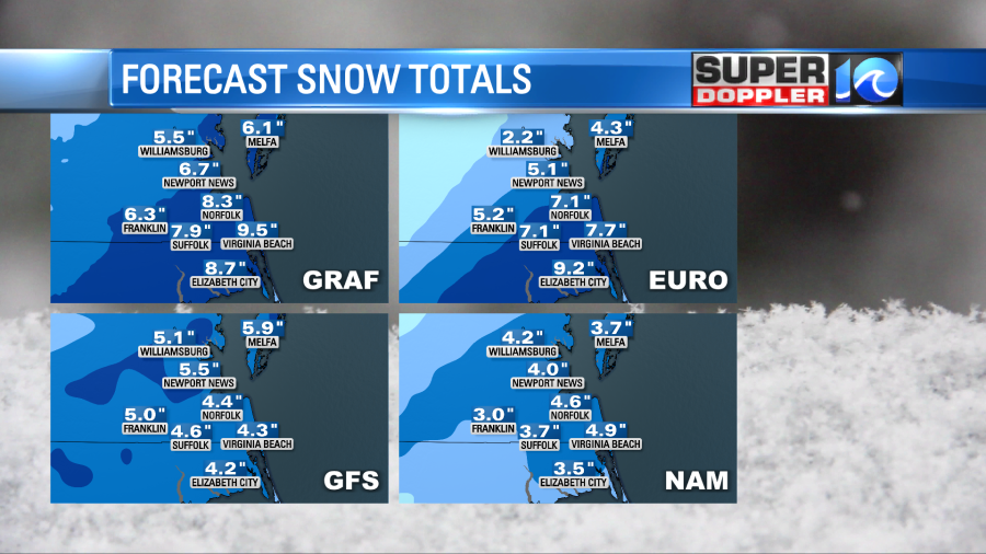
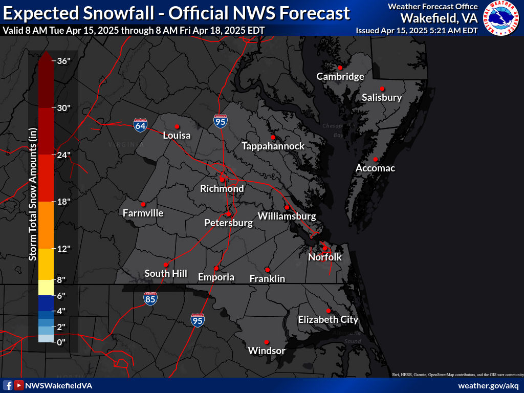
The GFS has the least amount which is interesting. It did pretty good with the last weather system. The NAM has flipped around like a flopping fish in the last 24 hours. At one point it had about 12-15″. Our model had about a foot when I got in. Now it has dropped to about 6-8″. Keep in mind that some of these totals include the first round of melting mix and snow. That’s possibly an inch that will melt. I think that’s the case with the GRAF model. Here is the morning forecast from the National Weather Service. It’s their most likely snow scenario from this morning.
So putting all of these together…here is my latest snowfall forecast:
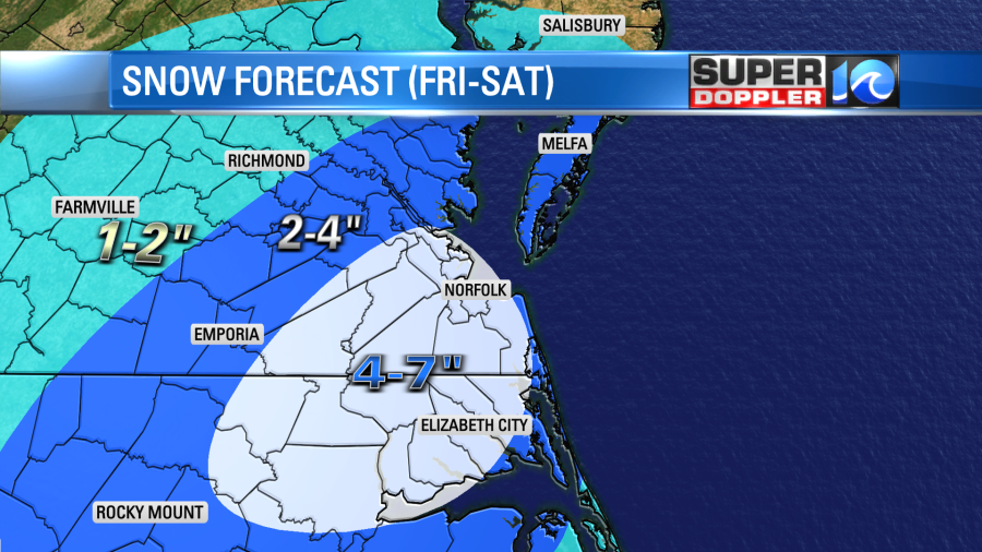
I do think some spots could see 8″ or a little more, but I think that will be a small area. Here is one more thing to keep in mind…I haven’t talked about one model. The high resolution NAM. It actually came in this morning with the least amount of snow by far. It has most of the precip TONIGHT (a couple of inches of melting mix and light snow) with very little reaching north/northwest of Virginia beach Friday and Friday night. It has practically nothing Saturday morning. With the models trending south lately I wonder if it is on to something, or if it is just a quirky outlier. It does still, however, show that possible icing near the state line for a time.
That icing could be a problem for some areas tonight and tomorrow. We’ll have to watch it carefully.
Today you should get the snow shovels and snow brushes out. Gas up your vehicles and the generators. Some locations may lose power. Winds won’t be too strong the entire time. Wind gusts will be to 35mph for a while though. If some ice or heavy/wet snow gets on the power lines, then some of them could fall. Roads will likely be tough to get through Friday night into early Saturday morning. So some businesses may be closed. This could include some pharmacies. So be prepared for that possibility. There may be some drifting Friday night as well with the wind.
High temps will only be in the 30s on Saturday. So there probably won’t be much melting. Sunday looks dry with highs in the 40s.
Keep checking back for updates! Be safe out there.
Meteorologist: Jeremy Wheeler