Get ready for more crazy changes in the weather.
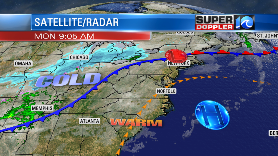
We had some big ups and downs last week. We’ll see another roller-coaster ride this week. It kicks off today. High temps will rise to the low 70s this afternoon. We have high pressure offshore with a light south wind.

It will be great weather for any Veterans Day events. It will be nice for even just spending some time outdoors with the family. You’ll notice on the map above that there is a large cold front to the west, and there is a large band of snow over the Midwest. The temperatures are very cold in the northern U.S. up into Canada. That’s where temps are in the teens and even single digits.

That cold front will move into our region tomorrow. The day will actually start pretty mild. We’ll be in the 50s early. Skies will be partly to mostly cloudy. Through the day we’ll have moisture increasing along the front. Temps will fall to the 40s by midday.

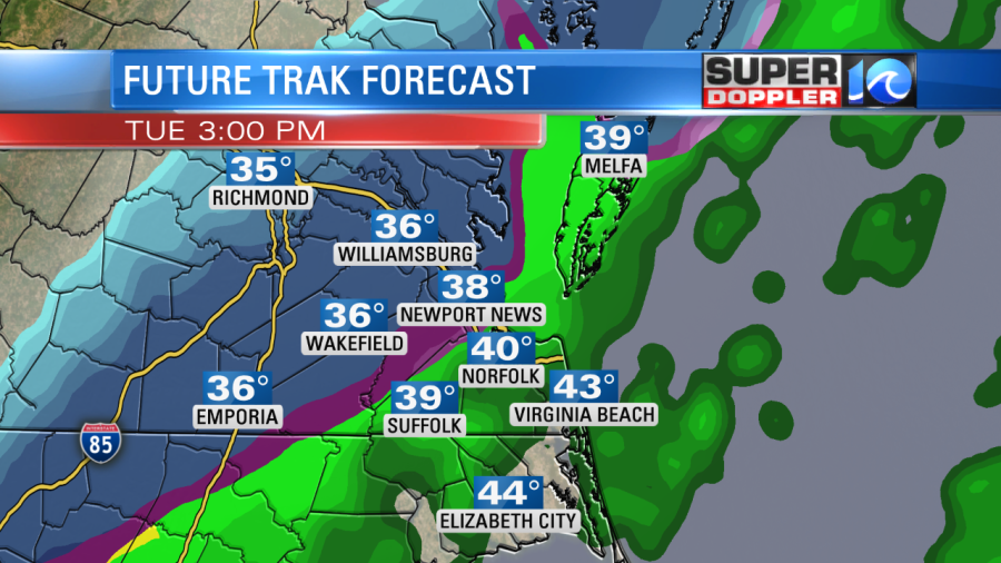
The wind will really pick up out of the north. It could gust to 30 mph. Winds aloft will also be out of the north. In the upper levels this will allow the temperatures to fall to cold enough levels for the rain to change over to a mix during the afternoon over some of the region. Our Future Trak model shows more of a zone with snow than a mix. It has that changeover between Richmond, Newport News, and Gloucester by 3 p.m.

The mix zone drops farther southeast between 3 and 6, but dry air does start to move in from the north.

We’ll start to dry out from 6 p.m. onward, except for a bay effect sprinkle or flurry in the evening.
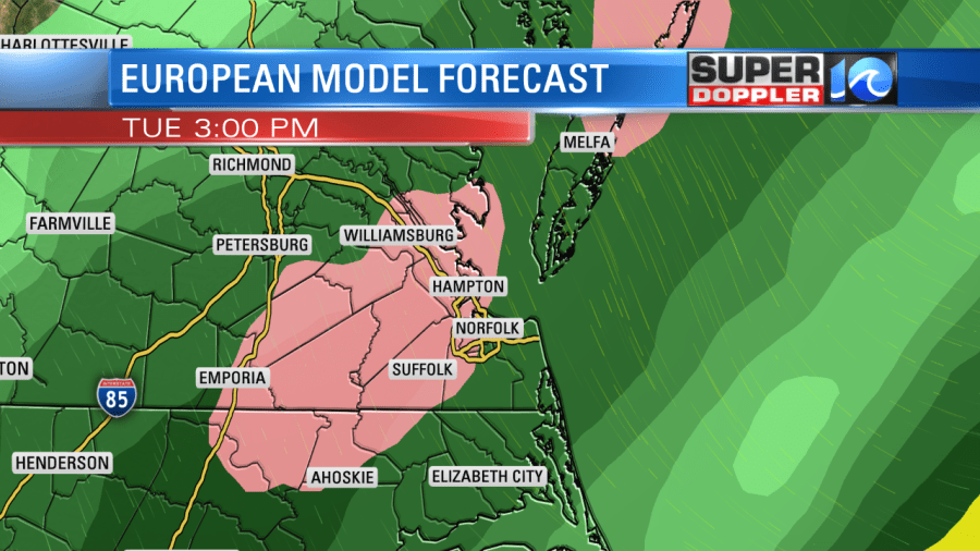
If you look at the temperatures that go with the precip in the above 2 graphics, you’ll see that they are in the 30s, but well above freezing. Plus, the soil temperatures are well above freezing. So most of what falls should melt. At this time I think we’ll have a mix of rain, sleet, and snow. I’ll admit…our Future Trak model is probably the coldest and snowiest out of all the models. However, I think it is a little too cold. For instance…Today I am calling for a high of 71. Future Trak is forecasting 66. So it is probably a little cold biased for tomorrow too. Here is what the European model shows for tomorrow afternoon.

You can see that it only has a small area of a brief mix. The GFS model is also much milder. So while I do think there will be a changeover to a mix, I also think a lot of it will melt. IF it comes down heavy for a time, then it could overcome the milder ground temps. So that would allow for some light/slushy accumulations on some grassy/elevated surfaces. But the general consensus is for mainly melting.
One problem that we could have isn’t so much from the snow/mix itself, but more from drivers’ reactions. The roads will be wet through the day, and there are no doubts about that. If we get the changeover to a mix during the evening, then there will likely be a lot of distracted drivers. If the precip comes down heavy, then some bridges and overpasses could briefly become slushy. That could create some major backups, so we’ll be tracking that possibility over the next 36 hours.
We’ll dry out Tuesday night with clearing skies. Again, there may be a few bay-effect flurries. We’ll be cold, dry, and windy on Wednesday. Low temps will be in the 20s and 30s. High temps will only rise to the low 40s. This is well below the average of 64 degrees. We’ll warm up gradually Thursday and Friday. Highs will be in the 50s. There may be a few more showers on Friday. Stay tuned for updates to all of this. I’m betting that the finer details on this mix will change before tomorrow, at least on Future Trak.
One cool thing is that the transit of the planet Mercury is happening today. It is happening until about 1:40 p.m. Here is a link with more details: Transit of Mercury.
Meteorologist: Jeremy Wheeler


