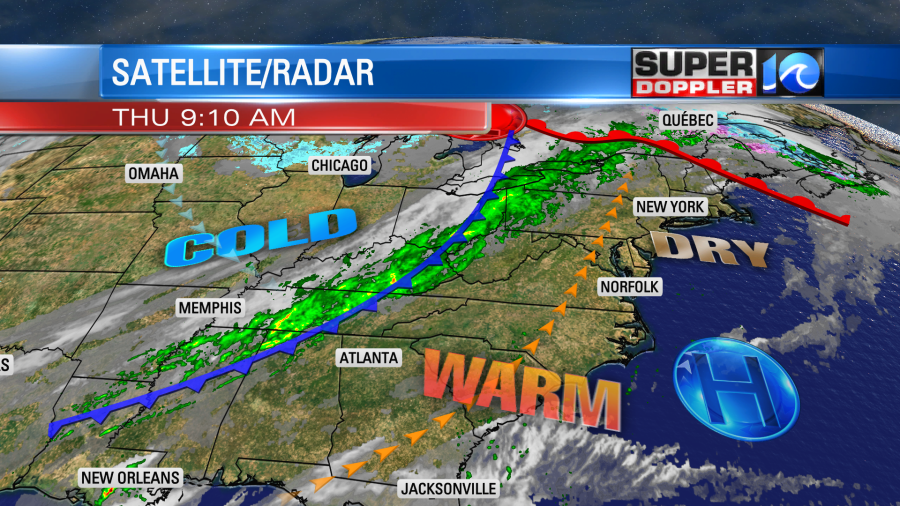
Today’s weather is going to feel more like the end of Summer than mid-to-late Fall. High temperatures are going to warm up quite a bit, and the humidity is increasing a little as well. We have a warm front to our north with a strong cold front to the west.
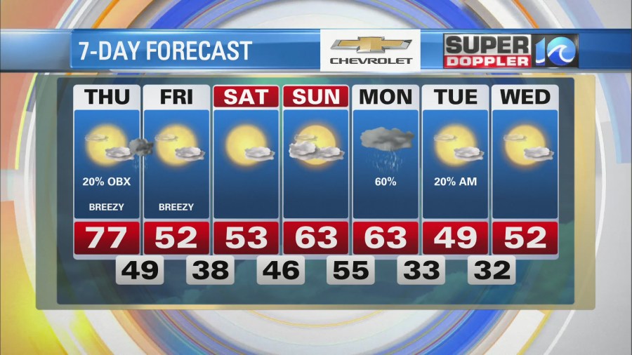
High pressure is offshore. We’ll have a steady southwest breeze through the day with gusts up to 25mph. We’ll also have a lot of sunshine with a few pm clouds. This will push high temperatures up into the upper 70s.

There may be a couple of 80s inland/south, but there won’t be too many of those. Dew points will rise to the upper 50s to near 60. That’s still not bad, but it won’t be as “bone dry” as it has been lately. It should actually feel very nice with the breeze. We won’t have any rain during the day except for some isolated showers over the Outer Banks.
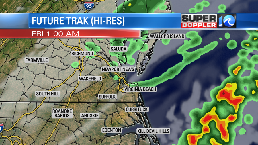
By tonight the cold front will be closing in from the west. We’ll have mostly cloudy skies. There will be scattered rain showers late. They will start up around midnight, and they will go until about 3-4am.
I’m hoping there’s a little more coverage for the rain as we still really need it. However, I’m also hoping in clears out for a bit early so that we can view the lunar eclipse (more on that in a moment).
The front will move offshore by tomorrow morning. We’ll have clearing skies early. Then we’ll have lots of sunshine through the day with a few clouds. However, the wind will be out of the north/northwest at 10-15mph with gusts to 25mph. This will hold the high temperatures down to the low 50s.
We’ll stay dry and chilly on Saturday. Low temps will be in the 30s. High temps will still be in the low 50s, but there won’t be as much wind. We’ll have some nice weather on Sunday with highs in the 60s and partly cloudy skies. Rain showers will move in on Monday. Highs will be in the 60s. This could impact some travel ahead of the Thanksgiving holiday. Then cold air streams back into the region. High temps will only be in the upper 40s to low 50s on Tuesday and Wednesday. At least it looks pretty dry during that time.
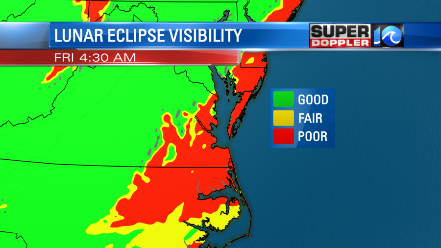
As far as the eclipse tonight here’s the latest info: While it will be a sight to see, unfortunately, we are going to have quite a bit of clouds in our region. The event is going to start up around 2:18am. We’ll likely be mostly cloudy with scattered rain showers at that time. The eclipse will peak around 4:00am.
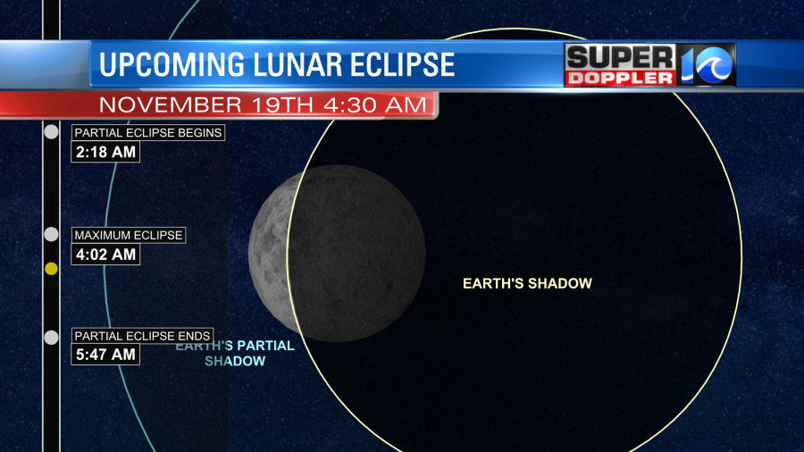
Now it is almost going to be a full lunar eclipse for our area. There is only a thin sliver of moon that won’t be covered by the Earth’s shadow. The eclipse will then decrease going between 4:30 and 5:45am. It will end around 5:47am. While there will be a lot of clouds at the time I’m hopeful that there will be a little bit of clearing between 4:30am and 5:45am. At least in some inland areas.
I’m hopeful but not optimistic.
In world news…While the headlines have talked about many big natural disasters this year, it is sobering to know that not all activity has been off the charts. In fact, the United States is below average for tornadoes this year. No EF-5 tornadoes occurred. (Thankfully). Also, even though we finished the normal list of names in the Atlantic for tropical systems, the overall amount of tropical activity is down in the northern hemisphere. This is mainly due to a quieter period in the Pacific, and that is in-turn due to the La Nina (cooler water) weather pattern. Here is a link with more details about this: U.S. Tornado and Northern Hemisphere tropical cyclone activity down this year.
Meteorologist: Jeremy Wheeler