Over the last 2 days we have had a cool & breezy weather pattern. We will continue with this for a couple more days. A very strong area of high pressure is to our north. We also have a very strong hurricane Teddy well offshore. There is a stationary front well to our south.
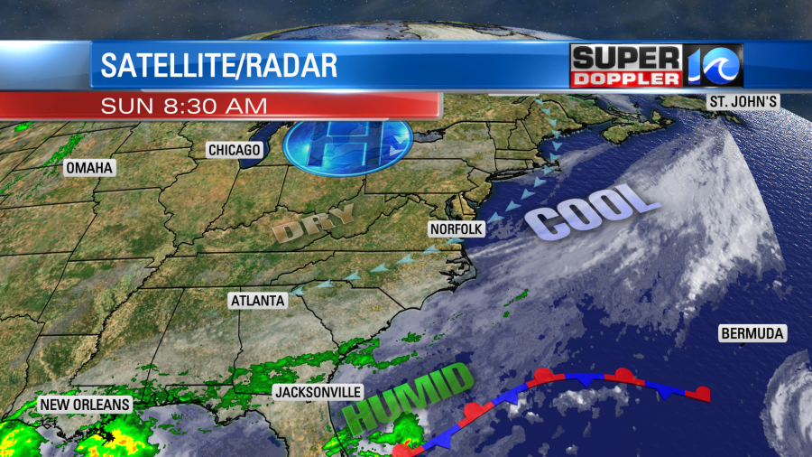
Teddy is a large hurricane which is basically a strong area of low pressure. So between that and the high pressure zone there is a strong and persistent northeast wind here (from the northeast). These winds are blowing over a large swath of water. We call that fetch. So this effect has led to some minor to moderate tidal flooding in the region. Luckily the tide forecast has come down since Friday. So today we are expecting minor tidal flooding over most of the region. Here is the forecast for Sewell’s Point:
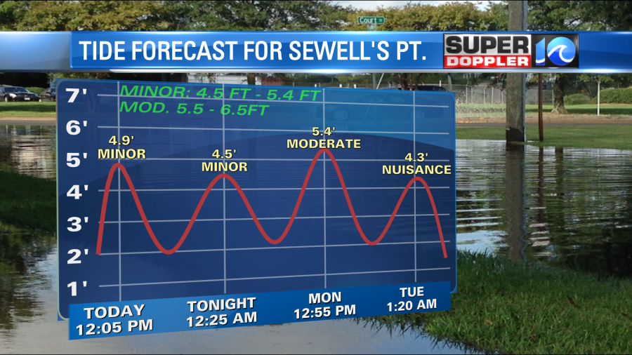
Notice that it’s minor levels today. Tomorrow it is up to almost moderate levels. (Keep in mind that this even came down from last night’s forecast). So that’s good news, but it means that some folks in low-lying areas will be affected. Here are the tides for some other areas. Notice that Duck, NC will have some moderate tidal flooding today. This is almost up to major levels.
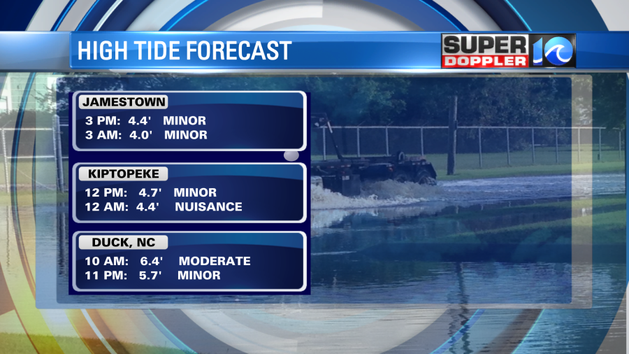
Tomorrow will have similar levels. Maybe just a touch higher.
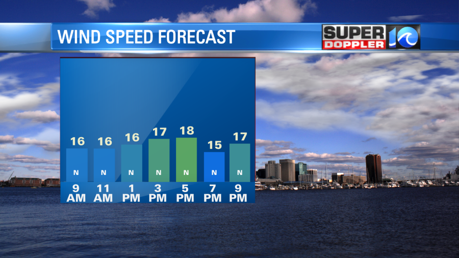
Outside of the tides we should have some nice weather over the next couple of days. Especially for those that love cooler weather. We’ll be partly cloudy today. There may be a stray shower or sprinkle coming in off of the ocean, but it’s a very low chance. Plus, we are very dry at the surface. Dew points are in the 40s and 50s. High temps will be in the upper 60s with a few 70s inland. The breeze will stay strong out of the northeast. It will run at 10-20mph with gusts to 30mph near the shore. It will be more towards 10-15m with a few gusts to 25mph inland.
By Tuesday the high pressure area will build-in on top of us, and Teddy will be gone. This will shut down the strong breeze, and it will produce a lot of sunshine. High temps will be in the upper 60s to low 70s. We’ll have lots of sun on Wednesday with high temps in the 70s. We’ll be in the upper 70s to near 80 Thursday and Friday with lots of sunshine. That will be awesome!
You may have seen the title to this blog, and wondered what it meant. Tropical burnout??? I jokingly mentioned that the tropics were on fire last week as well as the western U.S. This referred to the record number of storms in the Atlantic. However, it’s true that many people are burned out. This happened in 2005. We had so many tropical systems that we went into the Greek alphabet for the first time. People just started to tune out the tropical forecasts unless it affected them. I can’t blame them. Before 2004/2005 we didn’t always track every little hiccup in the Atlantic. Now we track every little tic over the water. With the big rise in social media, folks are blasted with information every few minutes. So I think now folks are REALLY burned out. On top of that you have all of the other bad news including COVID. So I am trying to only focus on the big systems right now, and the ones that could impact us. That’s why I’m not going even going to track Wilfred. It is a tropical storm in the middle of the Atlantic, but it’s forecast to fall apart in a couple of days as it moves west.
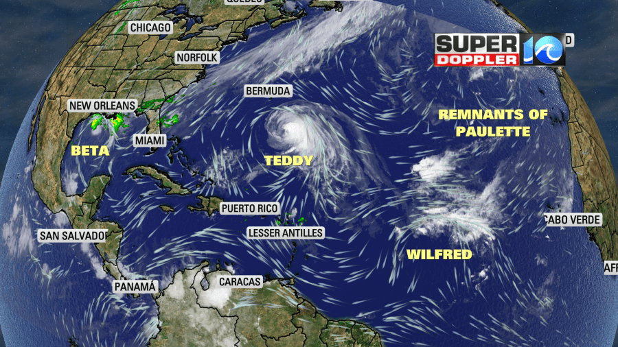
The remnants of Paulette could re-form in the eastern Atlantic, but until it does I’ll only occasionally give it a mention.
Now hurricane Teddy will have some minor impacts on us. Besides the persistent northeast wind, we are getting some high waves along the ocean front.

These will continue today. It will be a rough surf with a high threat for rip currents. This is on top of the higher tide coming in. So there may be some ocean overwash along the Outer Banks. Teddy will stay out to sea as far as the U.S. is concerned. It will pass east of Bermuda by tomorrow.
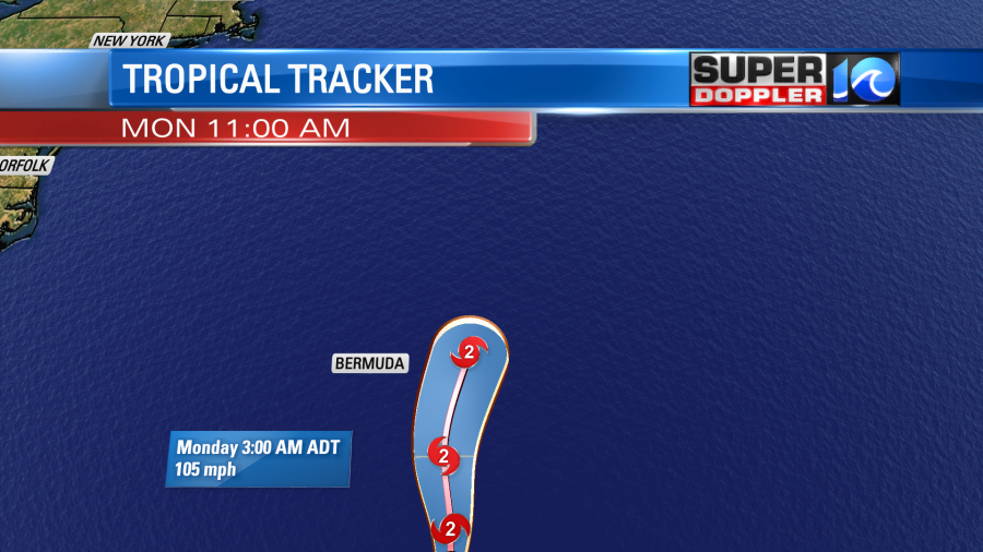
Then it will move north as a strong nor’easter type storm later this week. It is forecast to move over parts of Nova Scotia and Newfoundland.

Meanwhile in the Gulf of Mexico tropical storm Beta has been meandering around for a few days. It is now forecast to remain a tropical storm. It will move generally west/northwest over the next couple of days. Then it should curve to the north/northeast. It is expected to make landfall as a tropical storm.
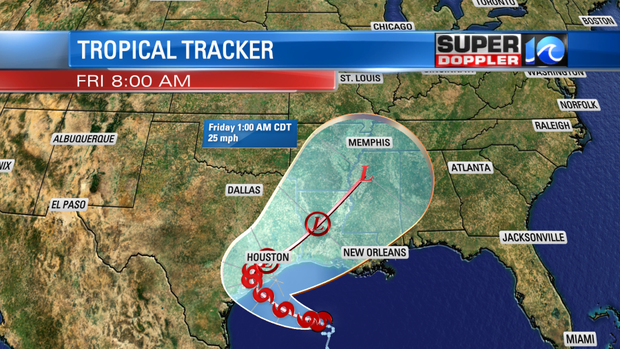
However, the rain has already been pushing onto the coast of Texas and Louisiana. Some areas down there could see 10-15inches of rain on top of what they’ve already had. At least the wind forecast doesn’t look too bad.
Alright…That’s a lot for a Sunday. Hopefully, I’ll be able to do some shorter weather blogs later this week as the weather gets nice and some of these systems fall apart. I can’t remember what quiet weather is like anymore.
Meteorologist: Jeremy Wheeler


