So far the forecast has behaved as expected. We did have cold rain yesterday in Hampton Roads with a wintry mix dropping southward during the day. By the evening the mix had made it down into the metro area.
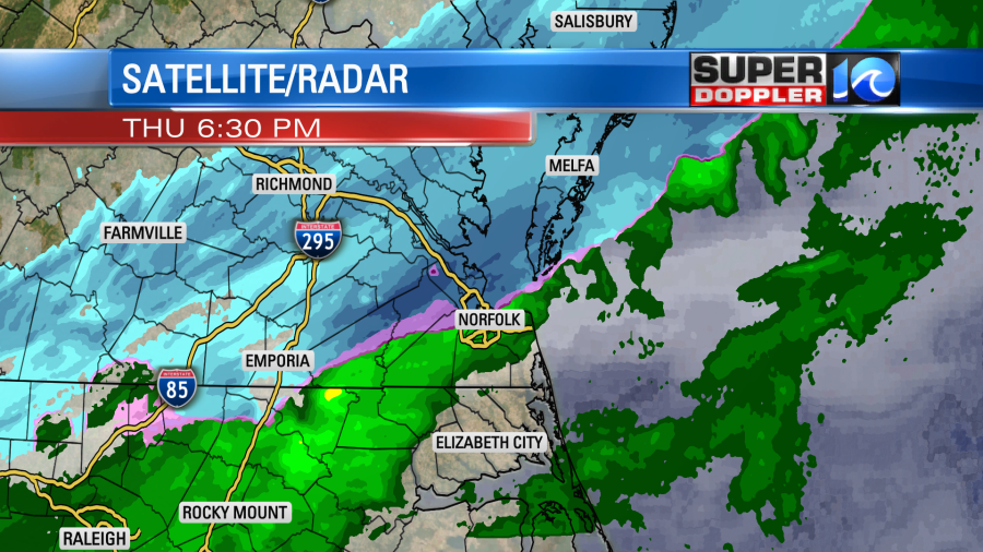
A lot of it did melt, but there was a light amount on the grassy areas and decks north of the metro. My weather watchers Barry in Gloucester and Scott in York county had a light coating on their lawns and decks. However, the roads were fine as expected.
This morning there was a little light mixed precip over northeast North Carolina.

Many of the models actually did a good job of forecasting that area to hang out this morning. While this was in a small area, the bigger problem for the region was wet roads and patchy black ice. Temps had fallen to the upper 20s to near 30 before dawn.
A strong cold front has dropped to the south, and it will stall out today. A weak area of low pressure will ride northeast along the front.

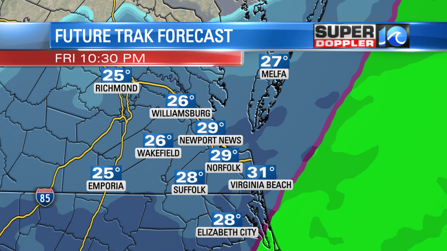
Also, and upper level pocket of energy will come through. Moisture will be shoved northward over the colder air mass. This will create some snow showers later today. It might take a while for the snow to develop. Here is our Future Trak model this afternoon.

The GFS is even a bit later with the snow as it doesn’t really have much until the evening. During the day we’ll have a strong north wind. It will run at 10-20mph with gusts up to 30mph. This will keep temperatures steady near 30 degrees. However, wind chills will be in the teens and 20s.
Tonight the snow will ramp up. Almost all of the models have the snow pushing northward overnight. Many of them take the coverage all the way up to the Northern Neck and Accomack County.
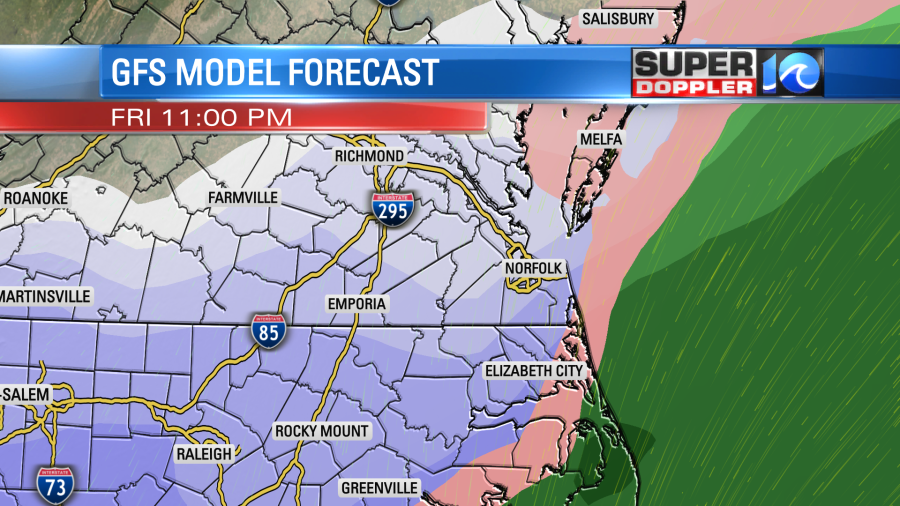
The snow may be briefly heavy during that time. Especially over the Southside and northeast North Carolina. The consensus is for the precipitation to quickly taper off between about 3am and 6am tomorrow. The GFS has it lingering for just a bit longer. there could be a few bay-effect flurries after that point, but for the most part the snow should move out. Then we’ll have mostly cloudy skies through the day Saturday. High temps will only be in the mid 30s. So there won’t be a lot of melting of whatever falls.
The models have really trended down with the amounts over the last 3-4 days. In the weather blogs over the last 2 days I mentioned that they were likely adding in the first round (last night’s precip), but most of that would likely melt. That has happened. So now the numbers are only showing what will fall today and tonight.
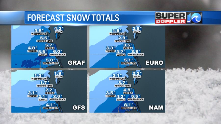
They GFS is still the lowest model, and it has been consistently lower for a while. It has the smallest window for snow. Possibly even less than the updated hi-res NAM model. For now I am siding with the higher amounts. There will be lots of dry air blowing in from the north at the surface, but I think we’ll have enough moisture pushing north in the mid-upper levels to produce more than a couple of inches. We did have a setup years go during president Obama’s inauguration where the models all showed snow, but the dry air pushed in from the north and ate it up. So we barely had any snow. It was an official bust. Things are different this time though, and the models are much better.
One thing the models may not be doing well with is the snow gradient. I think there will be a sharper cutoff as you go north and west of the metro. The National Weather Service snow forecast depicts this fairly well:
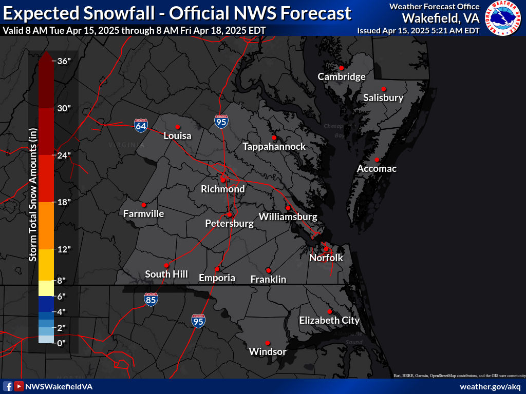
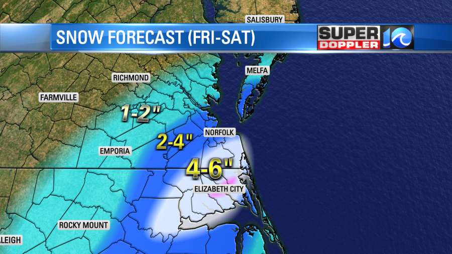
So here is my snowfall forecast based off the latest models.
A couple of inches of snow don’t typically cause too many problems unless they come in during or right before a commute. However, a few inches of snow make it harder to clear roads, and that makes driving difficult if not hazardous. Also, there might be some iciness under the roads by Saturday morning due to compaction and from recent melting/refreezing. This could make it tough to get around on Saturday. Again, with highs in the 30s there probably won’t be much melting on Saturday. So it may be tough to get to services Sunday morning depending on how much snow falls. We’ll see. However, we’ll have partly cloudy skies with highs temps in the mid 40s on Sunday. So that should melt a good bit of the snow.
There is pretty good agreement in the forecast, but things still could change a bit. Stay tuned for updates throughout the day.
Meteorologist: Jeremy Wheeler
Here’s what you need to know:
Roads and power
Closures and delays
Local preparations for winter weather
Statewide response
More weather resources
Download the WAVY News App to keep up with the latest news, weather and sports from WAVY-TV 10. Available in both the Apple and Google Play stores.


