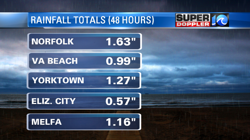
Yesterday, the rain was coming down. We had some heavy downpours in many locations.

Luckily it moved out just a little quicker than the models showed. We ended up with about 1 to 1.5″ of rain with a few locations getting about 2 to 2.5″.

My weather watcher Donna in Blackwater (S. Virginia Beach) had 1.4″ of rain. Scott in Yorktown had 1.27″, but Ralph in Seaford had 2.25″ of rain. A.J. on the lower Eastern Shore had 1.16″. Barry in Gloucester had 1.6″.
Officially in Norfolk we ended up over an inch above average for the month. We are up over 4″ for the year so far.

That was mainly caused by a big cold front which slowly crept in from the west. Winds were gusting to 30 to 40mph ahead of the front. Then they quickly dropped off behind it. It was surreal. Today the front is way offshore. High pressure is pretty far to the west.

You’ll notice that there are still some showers in our region. These are caused by an upper level low that is going to be sitting over the region all day today.

This is basically a big pool of spinning/colder air aloft. The very cold air aloft makes things unstable (tendency for air to rise). It doesn’t have to be too warm at the surface unlike a Summery day with pop-up thunderstorms. So we’ll have scattered rain showers on-and-off through the day. It won’t be a washout. However, there may also be a few thunderstorms during the afternoon due to the instability.

We won’t have that much rain today. Maybe 1 to 2 tenths of an inch. Skies will be mostly cloudy. Luckily there won’t be much wind. High temps will be in the upper 60s with a few 70s south.
Any rain showers that are left over this evening will move out tonight. We’ll have partly cloudy skies, and low temps will be in the 50s with some 40s inland. Tomorrow looks great! The upper level low will kick out to sea. High pressure will build in. We’ll have lots of sunshine through the entire day. High temps will be in the low-mid 70s with a light northwest wind.
We’ll have pretty good weather on Sunday, but the forecast is a bit tricky. The models show partly cloudy skies, but some have more clouds later in the day. They bring in some scattered showers. However, the timing is different. Some bring them in during the afternoon. Others hold them off until the evening. So check back to WAVY for updates on that. Either way it is going to be much warmer. High temps will be in the low-mid 80s.

That is pretty warm, but the high temps will be hitting the mid 90s over the central U.S. today and tomorrow. Some have asked when we are going to warm up for a longer stretch. Before I thought that would happen once we hit May. However, now I’m thinking this pattern will continue for a couple more weeks. (1 or 2 warm days, and then a cooler for 2-3 days). We’ll see.
Have a good weekend!
Meteorologist: Jeremy Wheeler


