A weak cool front will move in and stall out over the area on Sunday. High temps will be near 90 degrees, but it will still be humid. That will allow once again for a chance of heavy rain with any storms that we do get.


Highs this afternoon will be in the low 90s, with heat index values around 100. So, a little better than Saturday when we saw heat index values around 110.

We’ll finally cool down to the upper 80s on Monday. There will be some scattered thunderstorms, mainly in the afternoon. Then, we’ll have some typical summer weather for most of next week. Highs each day will mainly be around 90. Widely scattered afternoon thunderstorms are possible each afternoon.

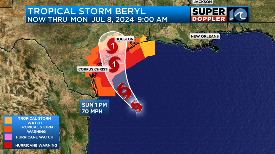
Meanwhile, Beryl is heading into the Gulf of Mexico. It will aim for south central Texas late Sunday into Monday. Today is the day, if it is going to do so – that Beryl will intensify with the structure getting better organized. The official NHC forecast as of Sunday morning calls for a hurricane at landfall. The storm will then move inland and weaken. No impacts expected here – and no additional development expected across the Atlantic basin over the next 7 days.

Hope you have a great weekend!
Meteorologist Ricky Matthews
Follow Ricky on Facebook and Twitter