
They are having a major blizzard up in the northeast state today. It started yesterday, and it continues today. There is a big area of low pressure offshore of the northeast coast. This is still producing some heavy snow along with strong gusty winds.

The snowfall has reached over 30″ in some locations. This has shut down many areas up there. Locally we have an upper level low overhead with high pressure to the west at the surface. There are upper level spokes of energy rounding the center of the feature. This will give us some scattered snow showers this morning, and they will turn into a scattered mix today. Here was the view on radar this morning.
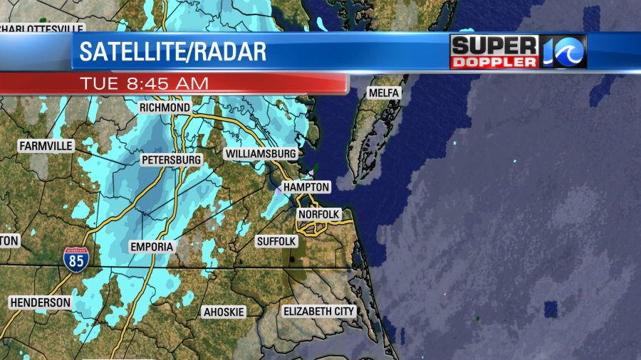
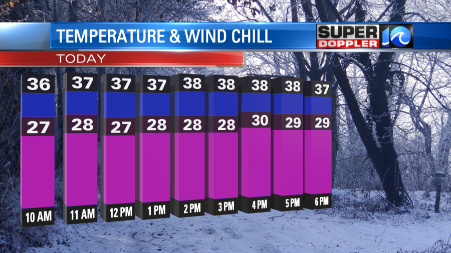
There was light to moderate snow falling in some places. However, surface temps were above freezing. So there was a lot of melting. Temps will warm (slightly) today. So we’ll reach the mid-upper 30s. This will change the snow over to a scattered mix through the midday and afternoon. While high temps will be in the mid-upper 30s, the wind chills will only be in the 20s.
Winds will blow out of the northwest at 10-15mph with gusts to 25mph. There will be some nuisance to minor tidal flooding during high tide.
The last of the precip will wrap up this evening. It will be a scattered mix with a few snow showers. Then we’ll dry out overnight. Lows will be near 30 degrees.
We could see a light dusting on some grassy areas for some locations in Hampton Roads up to the Mobjack Bay. Parts of Gloucester county, the Northern Neck, and the Eastern Shore could see about a half inch up to an inch of snow on the ground. Mainly on grass and decks.

That’s mainly because the temperatures there will be colder through the day. (Mid 30s for highs with some spots briefly dropping to the low 30s).
We’ll have lots of clouds tomorrow morning through noon. Hopefully, there will be some clearing later in the day. High temps will return to the 40s, but there will still be a northwest breeze. Thursday looks pretty good. I’ve got partly cloudy skies with a hopeful high of 50 degrees. Then we’ll warm up to the upper 50s on Friday. However, rain is likely for most of that day. At least the forecast for Saturday has dried out. High temps will be near 50. Then we’ll have some more rain on Sunday, and that might change to a wintry mix late.
Today is Groundhog Day. Punxsutawney Phil did see his shadow this morning. So he’s predicting 6 more weeks of Winter. However, I’ll head up to the Virginia Living Museum later today to see what Chesapeake Chuck has to say. We’ll have a Facebook Live around 11:30am on our WAVY Facebook page. https://www.facebook.com/wavytv10
Sorry! There’s no live audience this year due to COVID.
Meteorologist: Jeremy Wheeler


