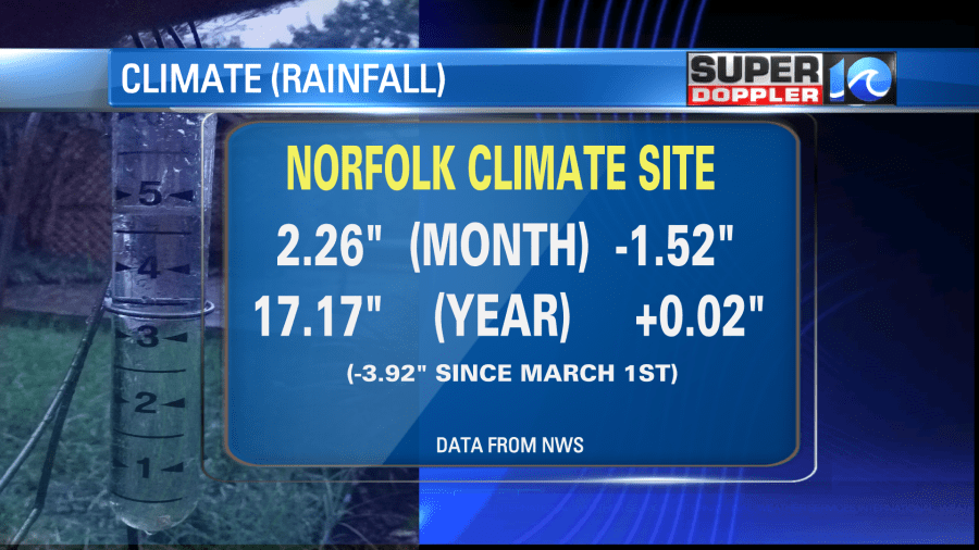
Recently we were on track to have the driest May on record. Before Saturday we only had about 0.4″ of rainfall. The driest May on record was 0.54″ in 1880. However, within two days this last weekend we dropped that title and even got knocked out of the top 10 driest list. Take a look:

We ended up with 2.26″ of rain for the month which was a big help in the short-term, but it was still 1.52″ below the average. We are pretty close to average for the year, but that’s because we had such a wet start to the year. We are down almost 4″ below average since March 1st.

We’ll see some more rain over the next few days now that we are going into early June. However, today we have some nice weather. We have a cool front stalling out to our south/southeast with high pressure overhead. There is a warm front building to our southwest.

We’ll be partly cloudy today with high temps in the upper 70s. There will be a few 80s inland. The pollen levels have dropped off. Plus, the humidity won’t be too high. So get out and enjoy the fresh air while you can.

You can’t see it on that map, but high temps on the west coast will be breaking records. There will be a few 100s already over parts of California today.
In our region tomorrow the warm front will lift up from the south. We’ll have some spotty showers in the morning ahead of the front. It may stall out or move very slowly for a while. So there will be some scattered showers and storms over northeast North Carolina. It should be more isolated in southeast Virginia. High temps will be near 80, but it will be more humid. Dew points will rise to the 60s.
The moisture will increase even more on Thursday. So we’ll be partly to mostly cloudy with some scattered showers and storms over the area. High temps will be in the 80s. We’ll have a cold front move into the region on Friday. It will be falling apart as it moves in. So it won’t cool us down hardly, but it will bring us some more scattered showers and storms. Some of the showers could linger into Saturday. High temps will be in the 80s. Hopefully, we’ll dry out a bit more on Sunday. I’ll talk more about the weekend in tomorrow’s weather blog.
Today kicks off the official 2021 hurricane season, but they have already been issuing bulletins for the Atlantic over the last couple of weeks. We have also have already had a tropical system (Ana). Here is the list of names for this season:

The forecast from NOAA calls for an above average season, but not as active as last year.

Luckily things are quiet in the tropics right now, and hopefully it stays that way for a while.
Meteorologist: Jeremy Wheeler


