
The local alerts for the heat have gone up a notch. The bulk of our area has something called an Excessive Heat Warning.

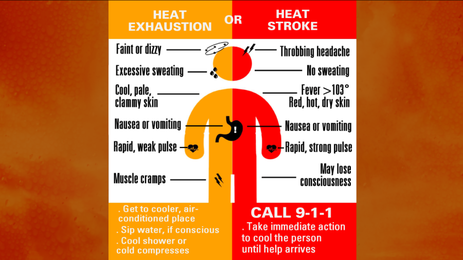
This is basically in effect through the entire weekend. There are Heat Advisories for the Eastern Shore and the Outer Banks. Both are bad news, but the warning is worse. A Heat Advisory basically means that the heat index will be between 105 and 110 for a couple of hours or more. An Excessive Heat Warning means that the heat index will be 110 degrees or higher. Heat illnesses are possible with a Heat Advisory. They are likely in a warning. Heat illnesses range from things like heat cramps or heat exhaustion to heat stroke, which is very dangerous. Here is a graphic that talks about the signs of heat exhaustion vs heat stroke.
You won’t melt just walking out the door, but you can’t take the heat for granted. Be sure to stay hydrated, and take lots of breaks in the shade or A.C. if you are doing outdoor activities. High temperatures this afternoon will run up into the mid-upper 90s. We had some clouds this morning. They should break up over the next couple of hours. If they hold on until noon, then maybe we’ll be more into the mid 90s. The heat index will be from around 100 to about 111 degrees during the peak heating of the day. Even this evening the heat index will linger in the lower 100s. As far as rain goes…We’ll have some isolated showers/t’storms this afternoon, but I only have the chance at 20%. It won’t cool down much tonight. Lows will be near 80 for most.
Tomorrow the upper level ridge will be stronger. High pressure will be stronger at the surface too. So we’ll have more sunshine through the day. This will allow high temps to rise to the upper 90s to around 100. The heat index will be up to 110, and in some places it could rise almost up to 115. Winds will be light and out of the southwest.
We’ll have the same kind of heat on Sunday, and a similar weather pattern. High pressure will sit to our southeast. Winds will continue out of the southwest. The pattern will finally break by Monday. A cool front will start moving towards us late in the day. We’ll have some scattered showers and storms moving in during the afternoon/evening. High temps will still be in the 90s, but they will be more in the lower 90s. The front will move through by Tuesday. High temps will drop to the low-mid 80s. Wow! That will feel great. There will be a lot of rain on Tuesday as the front will be very slow moving. It could possibly be a washout. We’ll see. Either way it will be most welcome to get the rain and the cooler temps.
Meteorologist: Jeremy Wheeler


