Hurricane Laura slammed into coastal Louisiana last night as a Category 4 hurricane. This was around Cameron, Louisiana.

The sustained winds were near 150 mph at that time. I’m not sure how high the storm surge got, but we’ll have reports of that probably coming in later this morning. Now it is moving north through western Louisiana as a Category 2 hurricane. It will weaken and move northward today. There was a report earlier this morning from Lake Charles when the sustained winds were about 98 mph. The gusts were up to 132 mph. Now the eye is starting to shrink and fill in. That is a sign of weakening. Here is the short-term track of Laura.
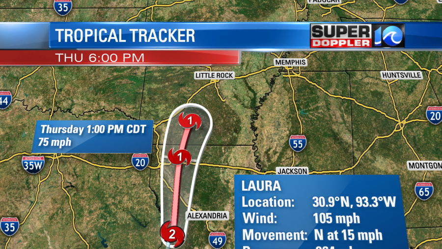
Hopefully, it will weaken faster than expected because the latest forecast has it as a category 1 hurricane almost all the way up to just south of Little Rock. It is expected to become a tropical storm by tonight (if not sooner). Then it will become a depression as it turns northeast tomorrow.
This is just a quick weather blog to have a fresh update. I’ll to a longer weather blog a bit later this morning. This will include how Laura could impact our region.
Meteorologist: Jeremy Wheeler
Tracking the Tropics
- How buying a real Christmas tree could aid western NC recovery
- Tracking the Tropics: Hurricane Oscar misses Florida in active October
- Gov. Youngkin establishes Office of Hurricane Helene Recovery and Rebuilding
- Rabies vaccination projects halted in states impacted by Hurricane Helene; here’s why that could be bad
- Three Ahoskie police officers deploy to western NC after Hurricane Helene


