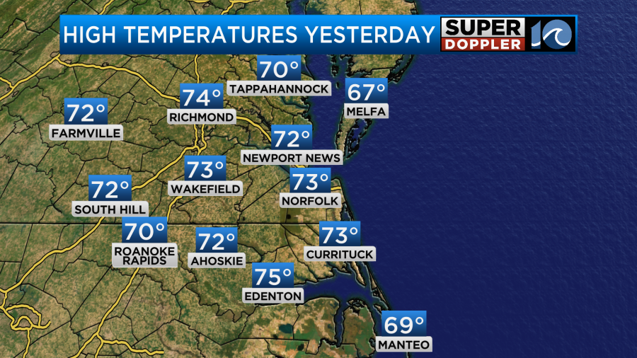
This last weekend was very nice! We had some comfortable temperatures, and it was dry most of the time. Yesterday, was pleasant and dry with high temps in the low-mid 70s.
However, today we are going to start a cooler pattern that will last for most of the week. A cold front is dropping to our southeast with high pressure off to the west.

Winds will be out of the north/northwest at about 8-12mph. There were some brief strong gusts early this morning, but the wind shouldn’t be too strong through the day.

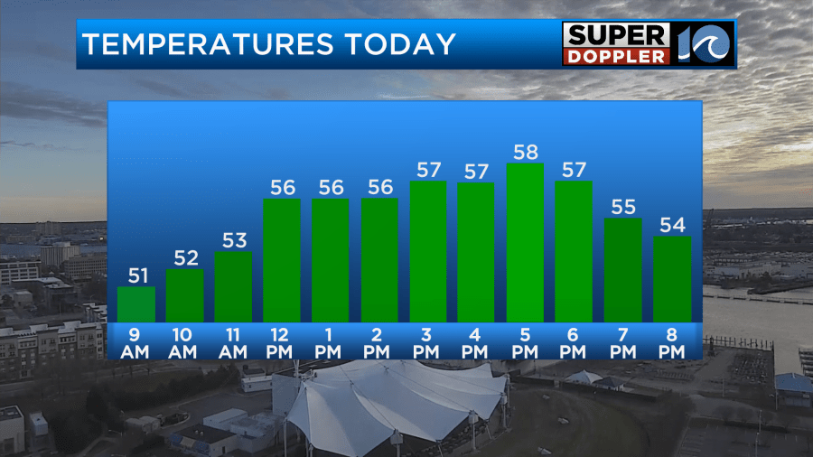
We started off with mostly cloudy skies, but we’ll have a mix of sun and clouds today. High temps will only be in the upper 50s with a couple of 60s inland and south.
Tonight we’ll have a wind shift and a small pocket of upper level energy swing through the region. So there will be some isolated showers in southeast Virginia with scattered showers over northeast North Carolina. This will be mainly between 9pm and 2am.
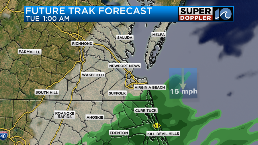
This precip will move out, and then quick clearing will take place after 3am. The wind will be out of the northwest at 10-15mph with gusts to 25mph for a time. This is going to drop the temperatures down to the upper 30s in the metro and south with some low-mid 30s inland and north.
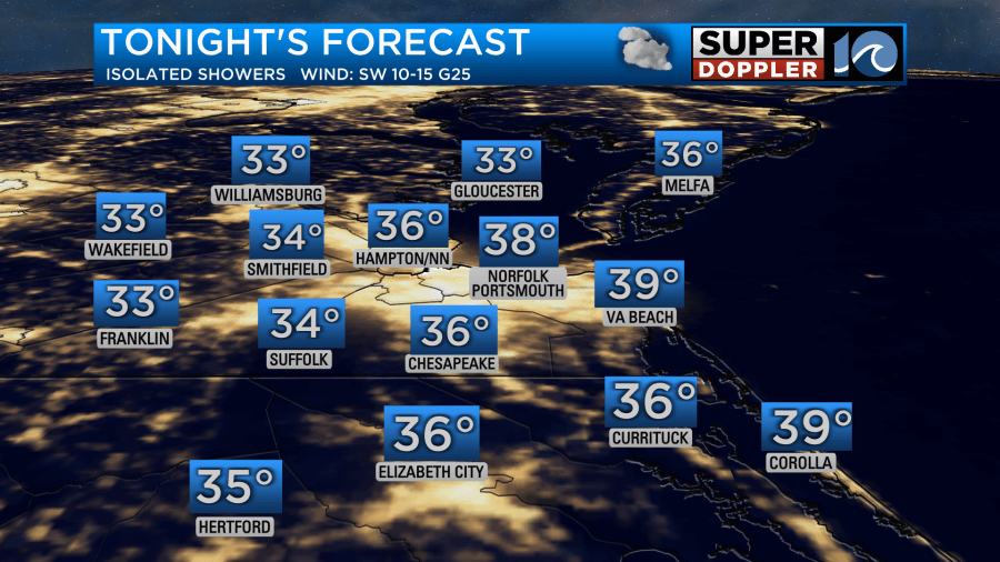
If the winds drop in some of those inland/rural areas, then there may be some patchy frost there early tomorrow morning. I doubt we’ll have it in the metro, but sometimes it gets pretty chilly in parts of Chesapeake and Newport News. So you might want to bring in the potted plants just to be safe.
We’ll be partly sunny tomorrow with a wind out of the northwest at 10-15mph with gusts to 25mph. The wind should settle down a bit in the afternoon. High temps will stay chilly. They will run in the mid 50s during the afternoon.

We’ll warm up for one day… Wednesday. Highs will be in the upper 60s as the winds turn out of the southwest.
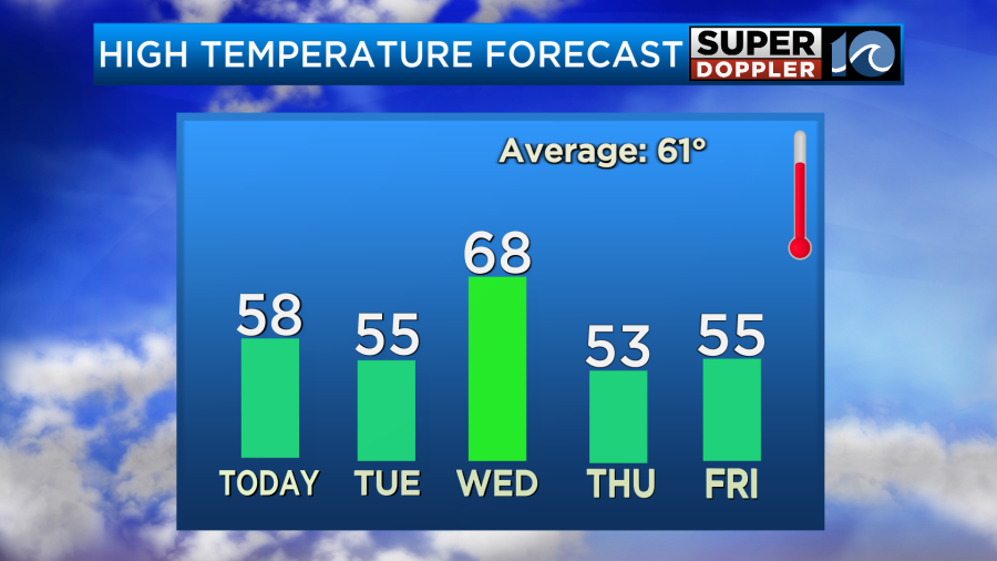
However, temps will fall as another cold front sinks south of the area Thursday into Friday. Highs will be back in the 50s.
By late Friday moisture will start to increase again as an area of low pressure forms to our south. This coastal low is forecast to move up along the shore into Saturday. It will probably bring us lots of rain and some wind during the day. The models have different timing for the start and end of the precip over the weekend. The GFS model starts the rain earlier, but kicks it out by Sunday. It has a lot of rain on Saturday.

The Euro model starts the precip a little later, but it keeps the rain going Saturday AND Sunday. We have plenty of time to see which way the models trend. Stay tuned for updates.
If you want to check out the Cherry Blossoms in the D.C. area, then you better start driving. The blossoms are already close to peaking. So you probably have another week (or 2 if you’re lucky) to be able to see the beautiful sight. The pictures are lovely, but I’m told they don’t do it justice. Here is an article with more information: Cherry Blossom Festival D.C.
Meteorologist: Jeremy Wheeler