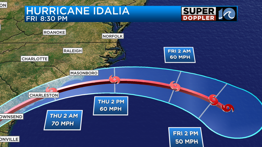
HAMPTON ROADS, Va. (WAVY) — Hurricane Idalia is expected to turn toward the ocean in the southern part of the Outer Banks after its landfall in Florida, but that doesn’t mean parts of the Hampton Roads region won’t escape its remnants.
The Super Doppler 10 weather team and the National Weather Service have highlighted the possible impact the storm could make on the region after it made landfall Wednesday morning in the Big Bend area of Florida.
The National Weather Service said impacts from Idalia will likely reach the Hampton Roads area on Thursday, “as deep tropical moisture increases across the Southeast United States.”
“There will likely be a sharp rainfall gradient across the local area as high pressure over the Great Lakes builds south and east on Thursday,” the National Weather Service said.
Super Doppler 10 Chief Meteorologist Emeritus Don Slater says that Idalia will likely stay at hurricane strength as it makes its way north into Georgia and into South Carolina later Wednesday, before moving out to sea around Myrtle Beach on Thursday.
“We aren’t going to take a direct hit,” he said of Hampton Roads. “Even the Outer Banks, you aren’t going to take a direct hit.”
Meteorologist Jeremy Wheeler says the southern Outer Banks could get several inches of rain, with other parts of North Carolina possibly getting 2-4 inches. Hampton Roads overall will likely see less than an inch.
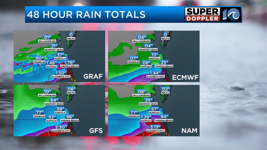
The National Weather Service said dangerous marine conditions are expected to develop by early Thursday, and strong winds lasting until early Friday, with seas seven to 13 feet Thursday, staying elevated into Saturday.
Jim Redick, Norfolk’s director of emergency preparedness and response, issued a Hurricane Idalia update Tuesday and said the following:
“Bottom line: The current track continues to benefit our community, but increased winds and coastal flooding are still to be anticipated arriving in Norfolk early Thursday morning.”
He said more problematic for the city would be the coastal flooding, and pointed people to the tide forecast.

He said that while it’s currently at the point in which the city of Norfolk garages would be opened (5.5 feet), “ponding will occur at the usual roads, intersections and low-lying areas during the 10 a.m. and 10 p.m. high tides Thursday and again Friday morning at 11 a.m.
“Any help raising awareness and otherwise encouraging the use of the Waze app to navigate around flooded roadways would be much appreciated,” Redick said.