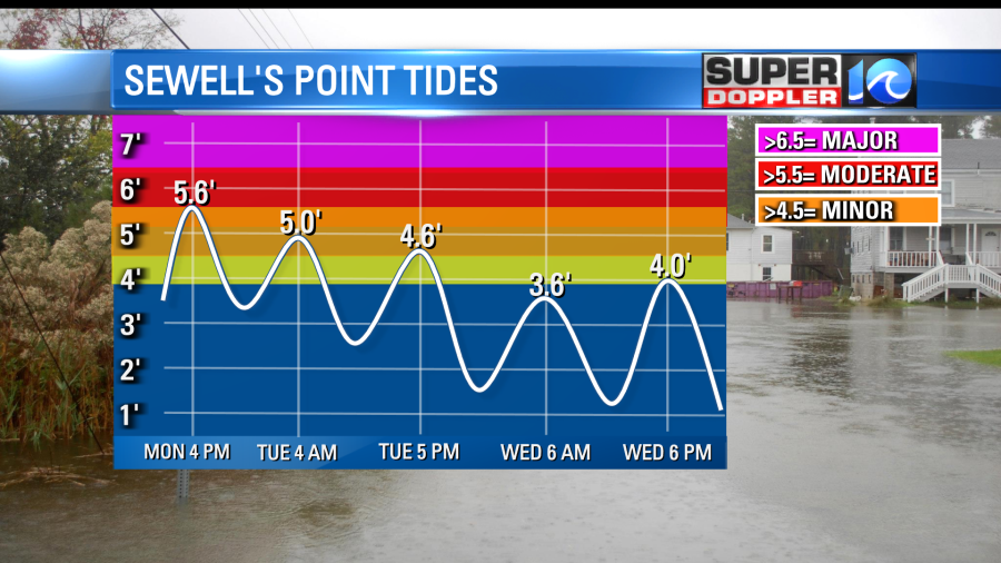
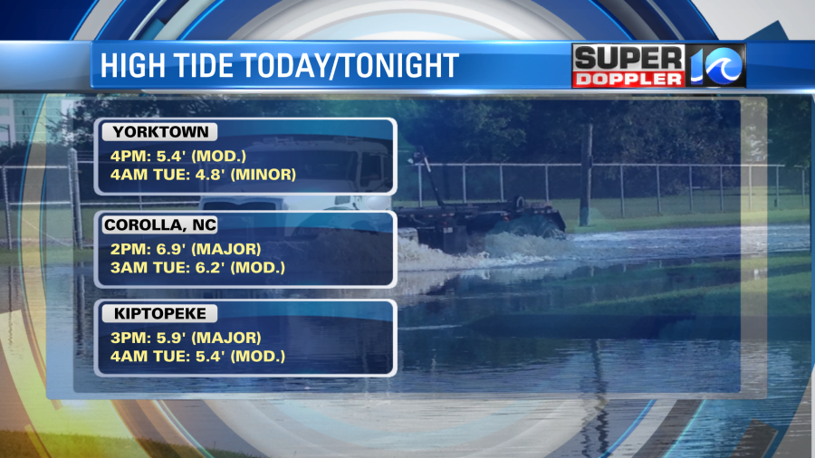
Update: Water levels continue to trend on the low end of the original forecast, so tidal flooding won’t be as bad as first thought. The wind slowly backing off is allowing some water to drain, and the afternoon high tide is more on the minor to moderate level of flood stage. Still, flooding issues will be present around Hampton Roads in the typical flood prone spots. Conditions will begin improve by Tuesday afternoon with some sun poking out by Wednesday. Updated high tide cycles are below:
___________________________________________________________________________________________________________________
Every storm is different. It’s interesting that this storm that’s affecting us today isn’t all that strong. However, the impacts could be big. Here’s the setup: We have a weak area of low pressure that is drifting offshore this morning. High pressure is very strong to our west, and it is drifting east just a little.
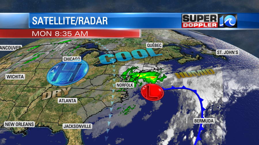
The effect is a strong pressure gradient between the 2 systems. That is creating an increasing wind out of the north. Winds will continue to increase today. It will be mainly out of the north through the day. Some of the gusts will be to 30-40mph. There could be a few gusts to 50mph near the shore.
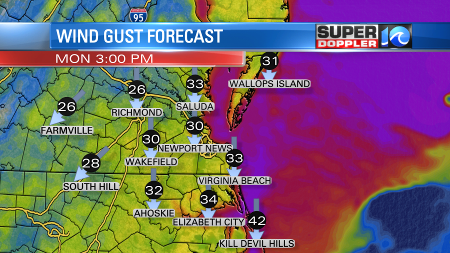
Inland gusts won’t be as strong. They will run about 20-30mph. There was a lot of rain and drizzle this morning. However, the bulk of the rain was light.
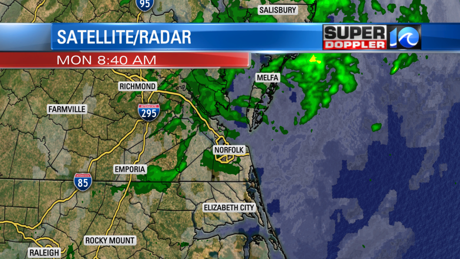
The rain will be on and off through the day including some drizzle at times. There will be less rain over North Carolina.
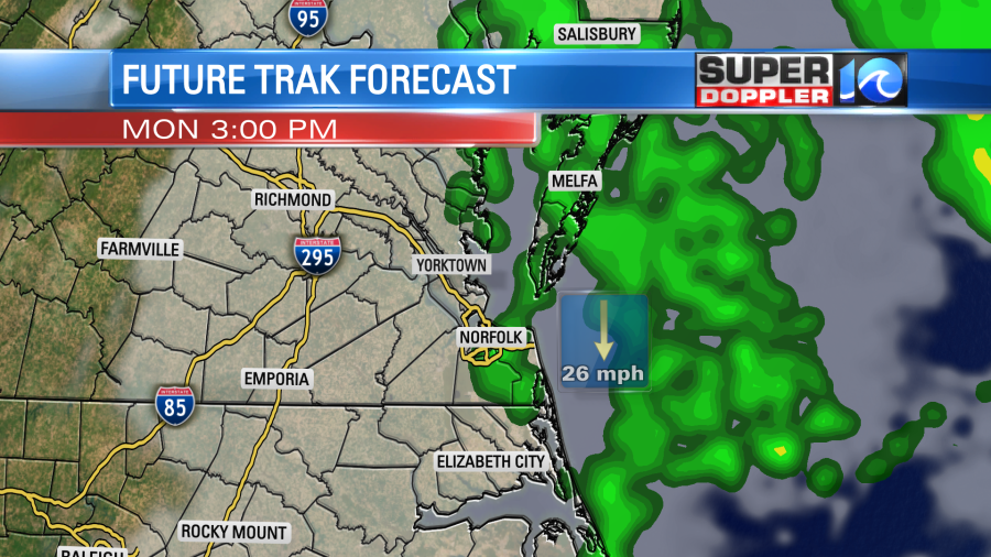
The rain will be mostly light to moderate, but it will feel heavy with the wind blowing so much. Scattered showers will continue tonight into tomorrow as the low continues to spin offshore.
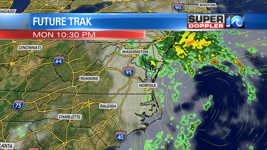
After a few final showers Wednesday morning we should start drying out for the rest of the week. amounts will be much lighter than last week’s storm system. We’ll have about a quarter of an inch of rain for most towns/cities with some locations seeing a half inch up to an inch.
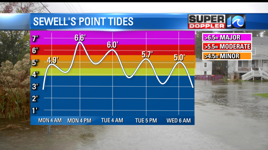
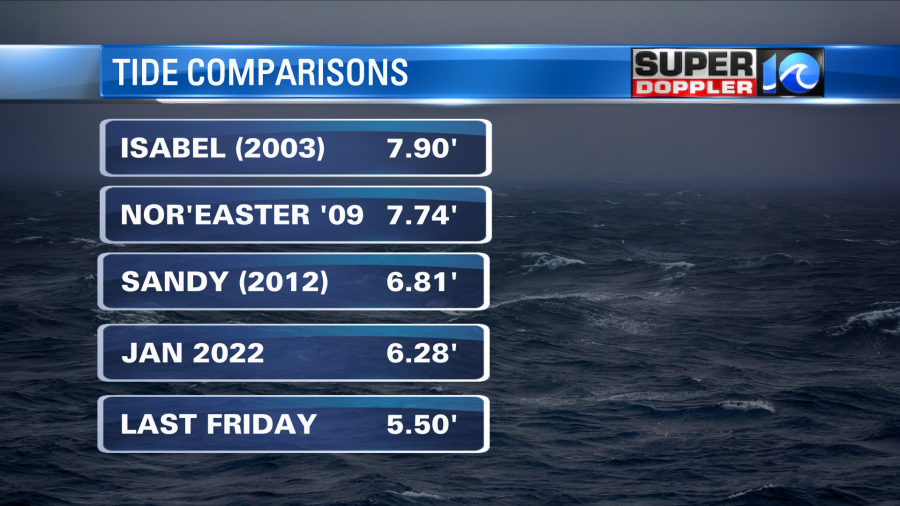
While the wind and rain won’t be as bad as last week there is a tradeoff… The tide will be much worse. Last week the high tide reached about 5.5ft at the highest level at Sewell’s Point. By this afternoon the tide is forecast to reach major levels.
The high tide for several other areas will reach major levels as well.

Here is a link to the National Weather Service’s “Coastal Flooding Page”. You can get updates for other locations there: NWS Tides.
The forecast has been trending downward, but there will still be a lot of issues. For reference the tide during hurricane Sandy was 6.81ft.
Now keep in mind that this forecast is very tricky. Normally a setup like this does not cause major tidal flooding. The low is not strong offshore. The wind isn’t nearly as crazy as last week. Plus, the wind really hasn’t had a long time to work on the water levels. Even yesterday the wind wasn’t too strong until the end of the day. Then early this morning the wind decreased a bit. So my theory is this: They have had some ongoing tidal flooding to our north around New Jersey. The wind up there has been mainly out of the east/northeast. We had a little elevated water levels on the north end of the Chesapeake Bay over the last 24 -48hours, but nothing too bad. So I think the sudden increase in strong north winds is going to flush the Bay water down towards the mouth while the higher Atlantic waters will also rush down from the Jersey Shore. These meeting waters will keep the water levels up over the southern Chesapeake Bay. The Atlantic side of the Outer Banks will also be brushed by this. That’s my latest theory anyway.
Another piece of tricky data… So far the wind hasn’t been as strong as forecast (by a little bit). Plus, the wind was a bit more out of the northeast than due north. So the latest models have been lowering the high tide forecast. Much more than we have presented on air. The reason for that is because the last thing we want to do is have the tide forecast going up and down several times. That will just confuse viewers. So we trend the forecast. At one point the forecast last night for this morning’s high tide at Sewell’s Point was 5.5ft. It ended up coming in at 4.84ft this morning. Now the water is going down. If the water drops a little more than forecast by 11am then we’ll be able to have more confidence in dropping this afternoon’s high tide. I’ve got 6.6ft for now. It may get down to 6.5ft or 6.4ft. it could be lower. If that happens, then it would drop down from “Major” to “Moderate” levels. We’ll see. I don’t want to give too optimistic of a forecast, but the trend has been good.
Whether the tide levels reach moderate or major levels, they will have some ocean overwash either way over the Outer Banks. The waves are big near the shore. They are running about 10-12 ft. Onshore waves are not as high.
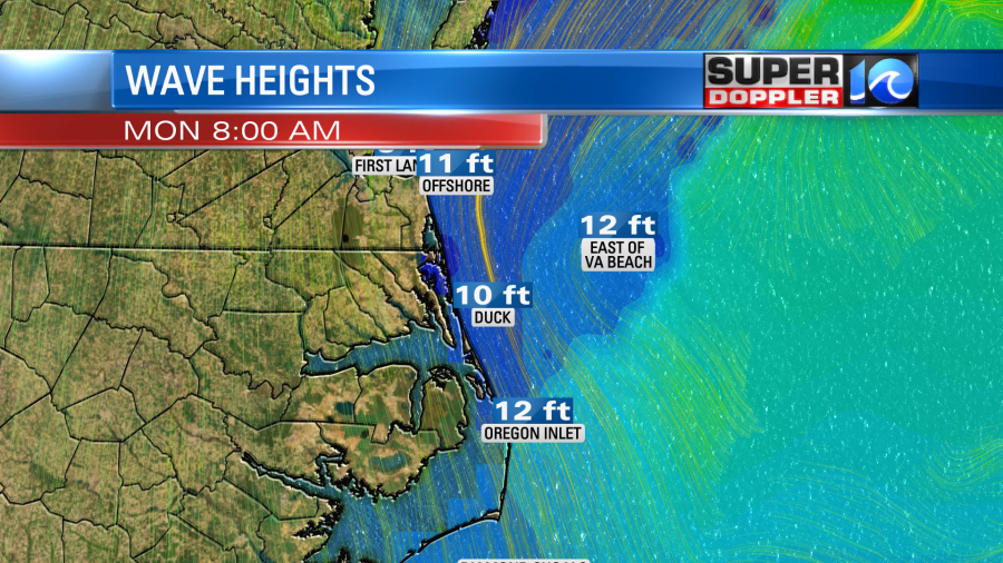
High tide will be around midday over the Outer Banks.
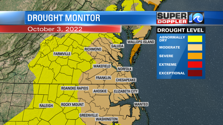
All of this rain will help out with the drought. The rain from last week didn’t make it into the update, but I believe we’ll drop at least a tier if not 2 for a lot of the region. Here is the latest:
We will stay cool over the next 3 days. High temps will be in the upper 50s to low 60s. Then we’ll be dry and in the 60s and 70s from Thursday into the weekend.
Before I go there is one more thing. There are 2 tropical disturbances in the Atlantic ocean.
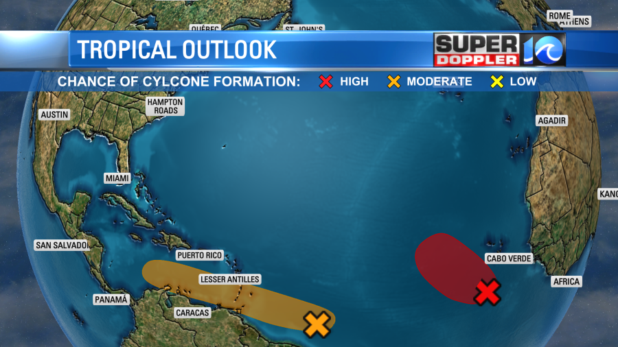
The one in the east has a high chance of formation, but it will likely move to the north/northwest and stay out to sea. The one in the middle of the Atlantic has a medium chance of formation, but it will likely head due west or to the west/northwest. We’ll have more on those features over the next couple of days. Stay tuned for updates!
Meteorologist: Jeremy Wheeler